Ham, Inkpen Hill & Lower Green Circular
Wiltshire Walk
County/Area - Wiltshire & Berkshire
Author - Lou Johnson
Length - 6.0 miles / 9.8 km Ascent - 650 feet / 197 metres
Time - 3 hours 40 minutes Grade - easy/mod
Walk Route Description
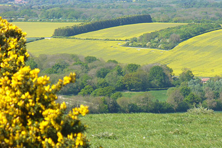
Click image to see photo description.
This walk on the Wiltshire/Berkshire border starts from the village of Ham. Using paths, tracks, and country lanes the route takes you over Inkpen Hill from where excellent views can be enjoyed. The walk descends the Chalk escarpment to pass through the outskirts of Lower Green before turning west along Bitham Lane to return to the start.
On road parking is available in Ham by the village green and Crown & Anchor Inn (grid ref. SU331631). Please remember to park with consideration for residents. After parking walk south passing the Inn on your left. Continue through the attractive village past the telephone box on your right to follow a narrow lane. Follow this lane for a further 600 metres to reach Manor Farm on your right (grid ref. SU332625). Just past the farm turn left onto the signed Mid Wilts Way. Follow the clear track for 800 metres to turn right across a field to continue following the Mid Wilts Way (grid ref. SU339626).
Reaching the foot of the downs, turn left along a track. You reach a gate after 200 metres where you turn right and follow the Mid Wilts Way half left up the steep escarpment to reach another gate (SU344620). Walk half left to join the track along the ridge of the downs. Turn left for just over a kilometre along the ridge crossing into Berkshire before reaching Inkpen Hill. Just before a dip in the ridge, turn left over a stile to reach Wigmoreash Pond (grid ref. SU359622).
Turn left just past the pond and follow the path which descends steeply down the escarpment. At the foot of the descent, you reach a gate (grid ref. SU357623). Pass through the gate and head north along the path for 1.5 kilometres to join a road (grid ref. SU356638). Turn right along the road passing S. Michael's Church partly hidden in the trees on your right. At the first road junction, turn left off the road at the fingerpost (grid ref. SU357639) to join Bitham Lane (track). 150 metres from the road bear left and continue along Bitham Lane.
Follow this byway for nearly three kilometres to reach the access road to Mount Prospero (grid ref. SU334642). At the fingerpost turn left and cross several fields to reach a small copse (grid ref. SU332636). Follow the path south to reach Spray Road (grid ref. SU334633). Turn right and continue back to the start.
Maps 

| Ordnance Survey Explorer 158 | Sheet Map | 1:25k | BUY |
| Anquet OS Explorer 158 | Digital Map | 1:25k | BUY |
| Ordnance Survey Digital Map Subscription | |||
| Latest Ordnance Survey Discounts | |||
Other walks nearby
| Walk 1947 | Coombe Gibbet & Walbury Hill near Inkpen | easy/mod | 6.2 miles |
| Walk 2180 | Hamstead Park from Kintbury | easy/mod | 7.3 miles |
| Walk 2114 | Hampshire and Berkshire Heights | moderate | 15.0 miles |
| Walk 3572 | Lambourn Valley & Great Shefford | easy/mod | 9.0 miles |
| Walk 3731 | Chaddleworth from Great Shefford | easy/mod | 8.0 miles |
| Walk 1928 | Pewsey Downs | easy/mod | 8.0 miles |
| Walk 3594 | Beacon Hill near Burghclere | easy | 1.5 miles |
| Walk 3595 | Old Burghclere & Burghclere from Beacon Hill | easy/mod | 5.6 miles |
| Walk 1737 | West Berkshire downs | easy/mod | 7.4 miles |
| Walk 2344 | Newbury to Hungerford via Kennet & Avon Canal | easy/mod | 9.0 miles |
Recommended Books & eBooks
The Kennet and Avon Canal
 Guidebook to walking along the Kennet & Avon Canal. The 94 mile route from Reading to Bristol is split into 7 stages of fairly easy walking and includes the UNESCO World Heritage Site of Bath and Bristol's Floating Harbour. 20 circular walks are also included, ranging from 4¼ to 9 miles, taking in the best sections of the canal.
More information
