Burnham-on-Crouch to Fambridge
Essex Walk
County/Area - Essex
Author - Lou Johnson
Length - 9.5 miles / 15.4 km Ascent - 100 feet / 30 metres
Time - 4 hours 50 minutes Grade - easy/mod
Walk Route Description
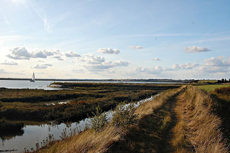
Click image to see photo description.
This linear Essex walk from Burnham-on-Crouch explores the River Crouch estuary with its tidal salt marshes and creeks. The route follows the coastal path for much of the way and provides easy level walking. The start is the small town of Burnham-on-Crouch and uses the regular train service to return from North Fambridge with a journey time of 10 minutes.
There are several options for parking including the carpark adjacent to the extensive marina (grid ref. TQ942961). Alternatives can be found elsewhere in the town. If you use any of the other car parks, then make your way to the river front and turn upstream with the river on your left to reach the marina. From the marina car park walk to the back of the marina and continue along the right-hand side of the marina to reach the waterfront. Turn right and follow the path beside the river. The path soon leads to a road at Creeksea (grid ref. TQ932957).
Go straight ahead along the road. After 300 metres, where the road bends to the right, turn left onto a signed footpath with fingerpost. You now have about 10 kilometres of easy walking following the path up the riverbank. Along the way you have a very brief climb over the Cliff before the path leaves the river and follows Althorne Creek with Bridgemarsh Island on your left. At Althorne the path kinks inland around a creek before continuing beside Bridgemarsh Creek to return to the banks of the River Crouch.
Nearing Fambridge, turn right inland at a fingerpost (grid ref. TQ857965) which is about 350 metres before Farmbridge Quay. Follow the path past Blue House Farm to join a road. Continue ahead (north) to North Fambridge railway station for a train back to Burnham-on-Crouch. On arrival, exit the station and bear right along Foundry Lane which leads back to the start.
Maps 

| Ordnance Survey Explorer 176 | Sheet Map | 1:25k | BUY |
| Anquet OS Explorer 176 | Digital Map | 1:25k | BUY |
| Ordnance Survey Digital Map Subscription | |||
| Latest Ordnance Survey Discounts | |||
Other walks nearby
| Walk 3746 | Bradwell on Sea Circular | easy | 6.5 miles |
| Walk 2924 | Tollesbury Wick Marshes | easy | 7.2 miles |
| Walk 3556 | Arlesford Creek & Brightlingsea Circular | easy | 6.0 miles |
| Walk 2920 | Egypt Bay & St Mary's Bay from High Halstow | easy | 7.5 miles |
| Walk 1637 | Rivers Swale & Oare | easy | 5.0 miles |
| Walk 2249 | Reculver & St Nicholas at Wade | easy/mod | 8.2 miles |
| Walk 3658 | Manningtree, Flatford Mill and Dedham | easy/mod | 7.1 miles |
| Walk 2104 | Blue Bell Hill to Kit's Coty House | easy/mod | 8.8 miles |
| Walk 2366 | The Naze from Walton-on-the-Naze | easy | 6.0 miles |
| Walk 3724 | River Box from Stoke-by-Nayland | easy | 6.0 miles |
