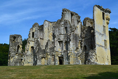
Wardour Castle, Ansty Down & Wardour Park
Wiltshire Walk
County/Area - Wiltshire
Author - Lou Johnson
Length - 7.5 miles / 12.2 km Ascent - 900 feet / 273 metres
Time - 4 hours 40 minutes Grade - easy/mod
Walk Route Description
Click image to see photo description.
This beautiful Wiltshire walk explores Wardour Park with its two castles, pleasant woodland, and the downland between Ansty Down and White Sheet Hill. The route follows paths and tracks although careful navigation is required on the approach to Ansty village. The walk includes two energetic climbs but generally the walking is relaxed and pleasant.
The start is the free Wardour Castle car park (grid ref. ST938264). After parking walk back to the entrance and follow the path beside the wire fence climbing in an easterly direction. Stay ahead on this path under an arch and into woodland. You soon exit the trees as you walk between fields. At this point you have a grand view of White Sheet Hill away to the right which will be crossed later in the walk.
Cross a cycle track and turn left on to a forestry track which runs parallel to the cycle track. After 25 metres, take the right-hand track at a fork. Where the track bends left and begins to descend, take the path on the right (waymarked with a yellow arrow on a tree). Follow the path as it zig-zags amongst trees to reach a stile on the right. Do not cross this stile and turn left. Continue on the path beside a fence to cross stile and then veer to the left and a kissing gate. Continue past a large, thatched cottage, take the stile on the right to a lane (grid ref. ST951266).
Turn right along the lane. At the first T-junction turn left. Follow the lane as it bends to the right and then to the left. You soon reach a finger post on the left and pointing right on the right (grid ref. ST954266). Take the left hand of the two paths between high hedges to reach a farm gate. Take the path to the right. Continue across a stile, through a paddock and then head approx. southwest across a large field to reach a stile that leads to the A30 at New Barn (grid ref. ST951258).
Cross the A30 with care and turn right and almost immediately left into Shave Lane. Continue along this byway for about 800 metres veering left to follow the track as it climbs across the scarp slope of Ansty Down. At the top (grid ref. ST962248) you can take a breather and enjoy the extensive view across the beautiful Wiltshire countryside.
At the top turn sharp right and head west on the track along the ridge. After two kilometres of very pleasant walking, you pass the trig point on White Sheet Hill. Beyond the trig point the track descends to the A30. With care go straight across to join Sands Lane. After two kilometres you reach the outskirts of Donead St. Andrew village. Passing stone cottages on your left you reach a crossroads. Turn right down the narrow lane signed no-through road. You are now on the Wessex Ridgeway.
Entering the woods take the first right crossing a waymarked stile to continue along the Wessex Ridgeway. Leaving the trees, you get a good view up to the new Wardour Castle on the left. Continue through Wardour Park to return to the Old Wardour castle and the starting point of the walk.
Maps 

| Ordnance Survey Explorer 118 | Sheet Map | 1:25k | BUY |
| Anquet OS Explorer 118 | Digital Map | 1:25k | BUY |
| Ordnance Survey Digital Map Subscription | |||
| Latest Ordnance Survey Discounts | |||
Other walks nearby
| Walk 2343 | Higher Pertwood & Wessex Ridgeway from Hindon | easy/mod | 8.1 miles |
| Walk 3743 | Win Green from Tollard Royal | easy/mod | 5.4 miles |
| Walk 1748 | East Knoyle & Hindon from West Knoyle | moderate | 9.6 miles |
| Walk 3626 | The Fovant Badges from Broad Chalke | easy/mod | 9.3 miles |
| Walk 2448 | Ackling Dyke from Sixpenny Handley | easy/mod | 8.6 miles |
| Walk 3237 | Bowerchalke & the Ox Drove | easy/mod | 8.0 miles |
| Walk 2171 | Knighton Hill & the Ox Drove | easy/mod | 5.8 miles |
| Walk 2465 | Steeple Langford Circular | moderate | 9.8 miles |
| Walk 2158 | Great Wishford & Grovely Lodge | easy/mod | 6.6 miles |
| Walk 2936 | Cold Kitchen Hill from Longbridge Deverill | easy/mod | 8.7 miles |
Recommended Books & eBooks
The Kennet and Avon Canal
 Guidebook to walking along the Kennet & Avon Canal. The 94 mile route from Reading to Bristol is split into 7 stages of fairly easy walking and includes the UNESCO World Heritage Site of Bath and Bristol's Floating Harbour. 20 circular walks are also included, ranging from 4¼ to 9 miles, taking in the best sections of the canal.
More information
