Sugar Loaf circular from near Abergavenny
Brecon Beacons/Bannau Brycheiniog Walk
Nat Park - Brecon Beacons - Brecon Beacons East
County/Area - Monmouthshire
Author - Lou Johnson
Length - 6.0 miles / 9.8 km Ascent - 1600 feet / 485 metres
Time - 4 hours 40 minutes Grade - moderate
Walk Route Description
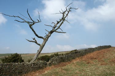
Click image to visit gallery of 6 images.
The town of Abergavenny is dominated to the north by the distinctive outline of the Sugar Loaf which rises to 596 metres above sea level. The summit provides an excellent place from which to view the southeastern section of the Brecon Beacons National Park as well as offering an objective for a decent walk. It is worth remembering that you need to save some energy for the latter stages of the walk where there is an ascent from the valley of St Mary's Vale back to the start.
The start is the small car park at the viewing point (Grid ref. SO268167) that can be reached by a narrow lane from the A40 a few miles west of Abergavenny. From the parking area take the clear track that leads north west. This takes you past a wall corner from where you get your first view of the main objective of the walk. Trending away from the wall, continue in a north-westerly direction ignoring paths that descend to your right to pick up a double path that leads in a large sweep to the summit of the Sugar Loaf.
Despite appearances, the summit is a minor ridge with a fairly steep drop to the north. The view is worth the climb with a 360 degree panorama across the River Usk to the south and into the heart of the Brecon Beacons to the northwest. To continue leave the trig point and head south east on a clear path that drops steeply at first before levelling out to reach a fence (Grid ref. 277179). Keeping the fence to your left continue along a broad ridge marked as Rholben on Ordnance Survey maps. After about 1.5 km the path drops steeply to reach a narrow lane. Go west along this turning right at the first junction. Continue along the lane to pass a small parking area on your left. Just after fork left to descend to a stream and a small bridge in pleasant mature woodland.
Follow this stream north. There are places where the path fades but providing you stay near the stream you cannot go wrong. After about 300 metres look out for an obvious track that forks left almost immediately doubling back on itself to climb up the hillside. Take this track which leads past a cottage and a small farm to reach a road.
Turn right and continue past a cottage on your right. A short way past this cottage take the track that climbs away from the road on your right. Once on this track follow it in a north-westerly direction and where it divides into two parallel tracks take the left hand track and this leads you back to the start.
Maps 

| Ordnance Survey Explorer OL13 | Sheet Map | 1:25k | BUY |
| Anquet OS Explorer OL13 | Digital Map | 1:25k | BUY |
| Ordnance Survey Digital Map Subscription | |||
| Latest Ordnance Survey Discounts | |||
Other walks nearby
| Walk 3717 | Table Mountain from Crickhowell | easy/mod | 5.0 miles |
| Walk 2670 | Ysgyryd Fawr (The Skirrid) near Abergavenny | easy/mod | 3.5 miles |
| Walk 3435 | Keeper's Pond & Blorenge | easy/mod | 7.5 miles |
| Walk 3134 | The Llangatwg Escarpment from near Crickhowell | moderate | 6.5 miles |
| Walk 1415 | Iron Mountain Trail - 'Llwybr Mynydd Haearn' - Part 1 | easy/mod | 7.5 miles |
| Walk 1512 | Iron Mountain Trail - 'Llwybr Mynydd Haearn' - Part 2 | easy/mod | 5.0 miles |
| Walk 1237 | Cwmyoy & Hatterrall Hill from Llanthony Priory | moderate | 10.0 miles |
| Walk 3203 | Vale of Ewyas from Llanthony Abbey | moderate | 10.7 miles |
| Walk 3342 | The Hatterall Ridge from Llanthony Priory | very hard | 10.0 miles |
| Walk 3622 | Llanthony Priory from Longtown | mod/hard | 7.0 miles |
Recommended Books & eBooks
Walking in Carmarthenshire
 Guidebook to 30 walking routes (2 to 10 miles) in Carmarthenshire, south Wales, including sections of Carmarthenshire Coast Path. Walks for all abilities, including coastal, river, forest and hill walks in Cambrian Mountains, Tywi Valley, Y Mynydd Du (Black Mountains) and Brecon Beacons. Easy access from Bristol, Cardiff and Swansea.
More information
Walking on the Brecon Beacons
 45 circular day walks are described in this guidebook to the Brecon Beacons National Park. From west to east, Mynydd Du, Fforest Fawr, the Brecon Beacons and the Black Mountains these mountain and valley routes offer many options, highlighting the natural features. The walks described explore dramatic waterfalls, wooded gorges and upland valleys.
More information
