Settle Circular
Yorkshire Dales Walk
Nat Park - Yorkshire Dales - Lower Ribblesdale
County/Area - North Yorkshire
Author - Peter Schofield
Length - 6.0 miles / 9.8 km Ascent - 1300 feet / 394 metres
Time - 4 hours 20 minutes Grade - easy/mod
Walk Route Description
Click image to visit gallery of 3 images.
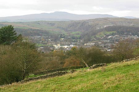
The small town of Settle is close to attractive Dales country and an interesting place to visit in its own right. This short Yorkshire Dales walk from the town offers a chance to take in some typical Dales scenery while leaving sufficient time to explore some of Settle's fine buildings.
The route starts outside the Tourist Information Centre in the Market Place. Turn left and then right into High St past The Folly, a house built in 1679 and now a museum. After 100m, bear right into Victoria St where more houses dating back to the 17thC can be seen. The road continues into Commercial St which descends and swings right to meet a bridleway, Brockhole Lane at grid ref SD820631.
Turn left into the lane as the town is left behind and an easy route continues for 1.2K to meet a tarmac lane (Grid ref. SD817620). Go left and follow the lane as it climbs to Lodge Farm. Bear left beyond the farm and continue to climb as Ingleborough comes into view on the left before reaching tarmac at the end of Mitchell Lane. Ignoring the tarmac, turn right along a track and after a further 200m, bear left into Lambert Lane, a typical Dales walled lane where views open out ahead towards Attermire Scar. Just after passing Preston's Barn, the route meets the minor road from Settle to Kirkby Malham (Grid ref. SD843630).
Go right along the road and after 100m, go left into Stockdale Lane. After 200m where the lane turns sharp right, go straight on over a stile and continue up a clear path over the saddle. Ahead Warrendale Knots and Attermire Scar loom up as the path descends over grassland past Sugar Loaf Hill to reach a stile (grid ref. SD838640). Cross the stile and turn immediately left on to a path which heads west beneath the crags.
From here the route crosses fairly level ground to divide after 300m. It doesn't matter which path you take as they rejoin after a further 600m. However it's worth taking the right hand route to a stile in the right hand wall at grid ref SD831640. Cross the stile and climb up a faint path to the summit of an unnamed outcrop with a small cairn to the left. Your reward? A panoramic view over the whole of Upper Ribblesdale with the Three Peaks dominating the scene.
When you've taken in the view, retrace your steps back to the stile and turn right on the path. After a few hundred metres, it begins to descend steeply with Settle spread out below. A track is reached at grid ref. SD823640 which continues the steep descent to a road at the edge of the town. Continue down the road for a short distance to reach the Market Place where any number of cafes and pubs are available to offer post walk refreshments.
Settle is well served by both bus and train services which make this walk suitable for those without their own transport. Buses stop in the Market Place while the station is a 300m walk from the start.
Maps 

| Ordnance Survey Explorer OL2 | Sheet Map | 1:25k | BUY |
| Anquet OS Explorer OL2 | Digital Map | 1:25k | BUY |
| Ordnance Survey Digital Map Subscription | |||
| Latest Ordnance Survey Discounts | |||
Other walks nearby
| Walk 2082 | Attermire Scar, Catrigg Force & Langcliffe | easy/mod | 7.5 miles |
| Walk 2603 | Feizor & Giggleswick Scar from Settle | easy/mod | 8.0 miles |
| Walk 2617 | Nappa Cross & Victoria Cave from Langcliffe | moderate | 9.5 miles |
| Walk 1404 | Oxenber and Wharfe Woods from Langcliffe | moderate | 10.5 miles |
| Walk 2649 | Attermire Scar & Malham Tarn from Stainforth | mod/hard | 16.5 miles |
| Walk 1251 | The Norber Erratics & Sulber Gate | moderate | 8.0 miles |
| Walk 2620 | Sulber Gate & Crummack Dale from Austwick | moderate | 9.5 miles |
| Walk 3092 | Malham Cove, Malham Tarn & Watlowes | easy | 4.4 miles |
| Walk 1051 | Gordale Scar & Malham Cove (Route 2) | moderate | 7.0 miles |
| Walk 1239 | Gordale Scar & Malham Cove | easy/mod | 6.5 miles |
Recommended Books & eBooks
Walking in the Yorkshire Dales: North and East
 This guidebook contains 43 circular day walks in the north and east Yorkshire Dales. It explores the dales, hills and moors between Kirkby Stephen and Pateley Bridge. Walking ranges from gentle 3 mile strolls to more strenuous day-long rambles across the Howgills, Wensleydale, Swaledale, Nidderdale, Mallerstang and Coverdale.
More information
Trail and Fell Running in the Yorkshire Dales
 Guidebook to 40 of the best trail and fell runs in the Yorkshire Dales National Park. Ranging from 5 to 24 miles, the graded runs start from bases such as Ribblehead, Dent, Sedbergh, Malham and Grassington and take in the region's diverse delights, from castles and waterfalls to iconic mountains such as Whernside, Ingleborough and Pen Y Ghent.
More information
