Langdale Pikes and High Raise FROM New Dungeon Ghyll
Lake District Walk
Nat Park - Lake District - Lake District Central Fells
Wainwrights - Harrison Stickle, High Raise, Pike O'Stickle
County/Area - Cumbria
Author - Lou Johnson
Length - 6.1 miles / 9.9 km Ascent - 2400 feet / 727 metres
Time - 5 hours 30 minutes Grade - mod/hard
Walk Route Description
Click image to see photo description.
The Langdale Pikes are one of the many highlights in Great Langdale. Their easily recognised tops come into view as you enter the valley from Ambleside along the B5343 from Skelwith Bridge and Elterwater. This Lake District walk includes the following Wainwrights - Loft Crag, Pike of Stickle, Harrison Sickle, Thunacar Knott, High Raise and Sergeant Man with the option of including Blea Rigg. The walk initially follows well-trod paths however route-finding can be problematic from Thunacar Knott to High Raise and down to Stickle Tarn. A 1:25000 map is a useful accessory on this section. In mist good compass skills will be required.
The start is the pay and display car park at New Dungeon Ghyll (grid ref. NY296064). Note that this area is very busy with walkers so parking space may be at a premium. Exit the car park using the entrance in front of the toilets. Turn left and take path through a gate and then through a hole in a stone wall. Shortly after bear left following a path to reach a gate. Go through the gate and turn immediately right. Follow ascending path with wall on your right. Continue up to cross a stile and turn left over a steam to follow the uphill path.
Reaching a Y-junction marked by a large cairn (grid ref. NY279071), bear left and walk north-west. After about 150 metres (grid ref. NY277072) go left and make the short diversion to reach the summit of Loft Crag. After enjoying the excellent view, return to the main path and continue to the next junction of paths. Go left and continue to the summit of Pike of Stickle where the final section is an easy scramble.
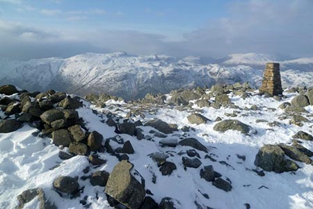
Descend from Pike of Stickle using the approach path and descend east along the cairned path. At a large cairn bear left along a grassy path to reach a cross path with a cairn. Turn right and walk up to the summit of Harrison Stickle. Retrace your steps back to the junction and continue north to arrive at Thunacar Knott (grid ref. NY279079). The next section requires care in poor visibility. Continue north on less well-defined path to pass a small tarn and follow a broad ridge. The path initially descends but eventually starts to climb leading you to the summit of High Raise with its trig column and wind shelter (grid ref. NY281095).
From the summit, turn south-east to a small tarn and the follow the ill-defined path initially along a line of old fence posts. The path veers away from the old fence line and joins a stony path that leads to the summit of Sergeant Man (grid ref. NY286089). Descend north-east for a short way and then turn right and continue path to reach a junction (grid ref. NY292084). From here you can continue south-east to Blea Rigg if desired. To continue the route head south-south-west on intermittent paths to reach the shore of Stickle Tarn.
Continue along the shore (with tarn to your right) to reach the outflow. Cross Stickle Ghyll and turn left descending alongside the stream. The path crosses the ghyll and descends to a stile. Cross the stile, re-cross the ghyll on a bridge and follow the descending path back to the start.
Maps 

| Ordnance Survey Explorer OL6 | Sheet Map | 1:25k | BUY |
| Anquet OS Explorer OL6 | Digital Map | 1:25k | BUY |
| Ordnance Survey Digital Map Subscription | |||
| Latest Ordnance Survey Discounts | |||
Other walks nearby
| Walk 1132 | Great Langdale & The Crinkle Crags | mod/hard | 7.0 miles |
| Walk 1157 | Bowfell and Esk Pike | hard | 8.8 miles |
| Walk 2037 | Bowfell & Rosset Pike via the Climber's Traverse | hard | 7.5 miles |
| Walk 2818 | Bowfell Circular from Great Langdale | mod/hard | 7.0 miles |
| Walk 1739 | Crinkle Crags and Bowfell (Oxendale Horseshoe) | hard | 7.8 miles |
| Walk 1144 | Lingmoor Fell | moderate | 8.0 miles |
| Walk 1171 | Pike o' Blisco | moderate | 5.0 miles |
| Walk 2582 | Pike o' Stickle, Harrison Stickle & Pavey Ark | moderate | 6.0 miles |
| Walk 1141 | Elterwater circular | easy/mod | 4.0 miles |
| Walk 1059 | Colwith Force and Skelwith Force | easy/mod | 4.8 miles |
Recommended Books & eBooks
Outdoor Adventures with Children - Lake District
 Guidebook to 40 outdoor adventures in the Lake District with children under 12, including walking, cycling, orienteering, paddling, boating, hostelling and more. Graded activities for varying age ranges or for families with children of different ages.
More information
Walking the Lake District Fells - Buttermere
 Part of the Walking the Lake District Fells series, this guidebook covers a wide range of routes to 32 Lakeland summits that can be climbed from the Buttermere, Lorton and Newlands valleys, with highlights including Haystacks, High Stile, Grasmoor and the fells of the Coledale Round. Suggestions for longer ridge routes are also included.
More information
