The Ridgeway around Lewknor
Oxfordshire Walk
County/Area - Oxfordshire
Author - Donald Morton
Length - 13.0 miles / 21.1 km Ascent - 400 feet / 121 metres
Time - 6 hours 50 minutes Grade - moderate
Maps 

| Ordnance Survey Explorer 171 | Sheet Map | 1:25k | BUY |
| Anquet OS Explorer 171 | Digital Map | 1:25k | BUY |
| Ordnance Survey Landranger 165 | Sheet Map | 1:50k | BUY |
| Anquet OS Landranger 165 | Digital Map | 1:50k | BUY |
Walk Route Description
Click image to visit gallery of 6 images.
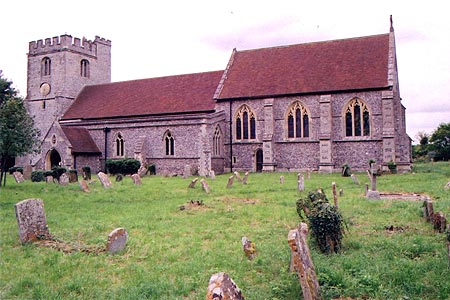
This walk starts in Lewknor, a village with a long history, lying just off the B4009 from Wendover to Wallingford just S of the M40. Park in the no-through road leading to Lewknor church (Grid Ref. SU716976). (The church itself is worth a visit with surprising examples of funerary statuary through the centuries.)
Walk back to the crossroads at the centre of the village and by Ye Olde Leathern Bottel (sic, sic, sic and sic) (or perhaps just sick) pub turn right down Weston Road. Pass Barley Close but when you come to Nethercote Lane, turn right. This starts off as a recognisably tarmac lane, but when it reaches the drive of Nethercote, it becomes a bridleway - actually the original lane which has been allowed to deteriorate beyond this point. It passes under the M40 and continues to the A40. Here dogleg left/right across the road to the continuation of the bridleway (initially a byway). This is a pleasant green lane which eventually emerges into an arable field, running along the edge, hedge right. When it reaches a crossing track turn right to come very quickly to a multiple junction. Turn left, still on a green lane, sign posted to Chinnor.
For the first time in the walk there is a slight rise. There are views of the wooded Chiltern scarp edge over on the right. Cross the lane running between Kingston Blount and Sydenham and continue straight on. When the hedges either side of the green lane terminate ignore what appears to be a crossing track and go on for another couple of hundred yards. Here at a waymark post turn right and follow a bridleway down a field break to a clump of trees ahead. Here the way turns into a gravel track to arrive at the B4009 at Crowell. Cross the road with care, doglegging left/right to find a footpath with pointer to the church, another ancient foundation but heavily restored in the 19th Century. In the churchyard go along the footpath along the S side of the church and exit via the lych-gate by the side of a pub, the Shepherd's Crook. Turn left past the front of the pub and at the end of the green turn right into a lane. This soon becomes a gravel track rising slightly to meet the Ridgeway at a four-way junction.
Turn right along the Ridgeway. Although at this point the Ridgeway runs at a low elevation, there are, nevertheless, extensive views to the right across Oxfordshire. Follow the Ridgeway which runs roughly SW, more or less straight, going over a country lane, bridleway and A40, and going under the M40, latterly with the Aston Rowant Nature Reserve on the left. Cross over the first lane* after the M40 and continue still in the same direction along the Ridgeway. At this point it is a green lane between hedges with views up the Chiltern Hills on the left and over Oxfordshire on the right. Later it enters a strip of woodland which, at least in summer, rather obscures these views. (Perhaps the woods were planted deliberately by the owners of Shirburn Castle to obscure any view of it. At this point it lies 3/4 mile to the right and it would be interesting to be able to see it because according to one web site it is Oxfordshire's very own Bodliam Castle, a perfect medieval moated castle but in private hands rather than the National Trust so not accessible to the public.) After a stretch through this wooded section the Ridgeway arrives at a junction with the Oxfordshire Way.
Turn right on the Oxfordshire Way, at this point apparently a tarmac lane, but as it turns out a private drive which becomes a public road only after about 1/2 mile just before reaching the B4009. Cross the B4009 and continue straight on down the lane (busier than it should be because it is a rat run round Watlington) until the village of Pyrton is reached. (Again the ancient manor house is very secluded, but if you pass through the churchyard and the wicket gate at the W boundary, by taking a few discreet steps into the garden it is possible to obtain a glimpse.) Having passed through the village, turn right on the bridleway/Oxford Way. Initially open, it becomes a green lane enclosed by hedges. This is running along the boundary of the parkland of Shirburn Castle, but again this is totally obscured by woods. Just before a "Private" sign turn left over a stile and diagonally across grass land to a gate and stile in the far corner. Cross the end of a green lane and go over another stile. Continue the previous line, but now over an arable field to the far corner. Cross the drive (and concealed ditch!) to a stile and then cross the field to the far left hand corner. Dog leg through a gate and continue up a field edge, hedge right. At the field corner turn left and continue following field edge, hedge right.
Just before the field edge curves left leave the Oxfordshire Way by going through a hedge gap to follow a field edge, hedge left. At the field corner turn left over a bridge and then turn right to follow the field edge, hedge right. The path enters woods. It comes out into a lane and when this reaches a T-junction turn right to come back into Lewknor. (And the pub. Never mind its name, it offers refreshment. Hope it's not 'ye olde foode'.)
*At the first lane after the M40 it is possible to shorten the walk by turning right and following it down to the B4009. Cross with care, doglegging left/right to find the start of a path zigzagging down to a road which leads to Ye Olde Leathern Bottel where you started. Turn right to reach the church.
Other walks nearby
| Walk 1335 | The Ridgeway at the End of the Chilterns from Watlington Hill | easy/mod | 10.0 miles |
| Walk 2324 | Christmas Common Circular | easy | 4.8 miles |
| Walk 2140 | Christmas Common & Greenfield circular | easy/mod | 7.8 miles |
| Walk 3359 | Christmas Common, Ibstone Common & Turville Heath | easy/mod | 8.5 miles |
| Walk 1333 | The Ridgeway around Chinnor | easy/mod | 9.0 miles |
| Walk 2398 | Turville Circular | easy | 4.1 miles |
| Walk 1617 | Saunderton circular via Bledlow Ridge | moderate | 11.3 miles |
| Walk 3520 | Princes Risborough circular | easy/mod | 9.5 miles |
| Walk 1965 | Piddington & Horsleys Green Circular | easy | 4.9 miles |
| Walk 2470 | West Wycombe & Bledlow Ridge | moderate | 8.2 miles |
Recommended Books & eBooks
No suggestions for this area.Messaging & Social Media
Message Walking Britain and follow the latest news.

Mountain Weather
Stay safe on the mountains with detailed weather forecasts - for iOS devices or for Android devices.