The Ridgeway around Chinnor from Bledlow Ridge
Chilterns Walk
Region - Chilterns
County/Area - Buckinghamshire & Oxfordshire - South Buckinghamshire
Author - Donald Morton
Length - 9.0 miles / 14.6 km Ascent - 700 feet / 212 metres
Time - 5 hours 10 minutes Grade - easy/mod
Walk Route Description
Click image to visit gallery of 4 images.
This walk starts at Bledlow Ridge which can be reached by turning off the B4009 at Pitch Green, from the A40 at West Wycombe or from the A4010 near Saunderton. The walk starts from where the Chiltern Way crosses the road just S of The Boot pub at Grid Ref SU794981. Park along the road as near as possible to the pub.
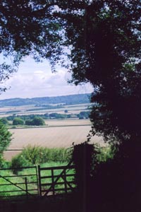
Commence by turning down the Chiltern Way on the pub side of the road. The Way here starts off as a gravel track as far as Crendon House and then becomes an enclosed grass track. At a double stile take the left hand one to continue down another enclosed path, but one with lovely views, right, over the Chilterns from Princes Risborough and running S. Continue straight on over a gravel track until a tarmac lane is reached. Here leave the Chiltern Way by turning right.
The tarmac lane, after passing some large houses, part of Rout's Green, becomes a gravel track until it reaches a gate. Here go straight on down a narrow bridleway, again providing extensive views of the Chilterns to the NE. After passing through a bridle gate the path, now wider, can be seen going straight on down into a "bottom" and rising up the other side. Keep on it, ignoring all bridleways and footpaths to left or right. At the top of the rise the path is clear through a stretch of downland reverting to scrub. Opposite some double metal gates it meets the Ridgeway.
Turn left and start climbing up Lodge Hill. The path is clear, generally the Ridgeway is well marked either with its name or an acorn logo, and the views from the Hill are lovely in all directions, with those across the Vale of Aylesbury opening up as the top is reached. The walk across Lodge Hill includes Drover Hill SSSI, a stretch across open downland and finally a gentle descent through woods. At the end of this, look out for a metal kissing gate in the left hand hedge. For once there is no Ridgeway marker but this is where you turn to go straight across a couple of fields to a lane at Grid Ref SP785005. Cross the lane and continue on the Ridgeway along a field edge, hedge left. Soon after the Chiltern Way comes in from the left, dogleg left/right through a kissing gate (again no Ridgeway signage) to continue the same direction but with the wire fence right. When the Chiltern Way diverges right continue straight on the Ridgeway. About 150 yards from the end of the field fork left towards powerline poles and a gate, leading out to a byway. Turn left and soon enter woods to follow the byway through woods and round the foot of Wain Hill to an interesting cottage by a track junction. Just before the cottage the byway has become a bridleway and at the far end of the cottage you turn left to start following a long straight stretch past Chinnor (do not turn left a second time past the end of the cottage). Initially it passes through woods, including to the left an RPSB reserve through which you could divert to rejoin the Ridgeway further on. Later when it emerges into the open, it becomes a well maintained gravel access road with several paths off to left and right before it reaches a tarmac lane. Cross the lane and continue on the Ridgeway which is now a green lane running between disused chalk pits. Go past another RPSB reserve and continue until a crossing Restricted Byway is reached. Here leave the Ridgeway and turn left.
Ascend a sunken lane. It comes out at a lane where you turn right and then immediately follow it as it turns left to go through scattered houses at Crowell Hill. Follow this lane for about .5km, looking out for Crowellhill Farm where you turn right; there is no bridleway finger post on the road but once you have made the turn you can see a blue waymark sign ahead. Follow this narrow bridleway (probably muddy all the time except the driest periods) down the edge of the woods. At a track junction take the left hand fork still going down through woods but now on a wider path. Eventually you get back to the wood edge. Here you are walking along the Buckinghamshire (on the left) and Oxfordshire (on the right) border; you are probably just in Buckinghamshire since a boundary bank with trees is to the right of the track. Continue following this obvious wide track down until it becomes a tarmac lane. After about 300m just past a conglomeration of farm buildings on the right the lane is crossed by the Chiltern Way which you rejoin here to follow back to Bledlow Ridge.
Turn left to go diagonally left up the hill. If you are unlucky and the path is not clear after ploughing aim about 25yards right of powerline poles. There is also a not very obvious marker post on the far side of the field and when you reach thus turn left for a short distance to a wide hedge gap. Turn right through this and then immediately right again through a bridle gate. Cross the pasture to another gate in the top right hand corner. Cross the drive and bear right down the tarmac, continue straight on down concrete to a field. Follow the field edge, hedge left to the corner and then plunge left though the hedge gap to a stile. From here a hedged path leads down to a lane. Turn left down the lane. At the first junction leave the Chiltern Way to go straight on, and at the second junction turn left. Just past Two Yews Cottage (odd name: at least three can be seen) fork right up to St Mary's Church, the parish church of Radnage where you rejoin the Chiltern Way. The 13th Century church is an unusual structure and the interior is well worth a visit; there are remains of 16th Century wall paintings and facsimiles of a number of interesting documents including the history of a black slave given to a Rector by one of his relations, plantation owners in the West Indies. The Chiltern Way passes through the church yard to the S of the church and exiting at the E end. From here bear right across fields and after two bridle gates bear left up to woods. Then quickly bear right through a gap between woods and across open down land. From here turn left to follow the Chiltern Way up an enclosed path, with good views S, to Bledlow Ridge close to the pub.
Maps 

| Ordnance Survey Landranger 165 | Sheet Map | 1:50k | BUY |
| Anquet OS Landranger 165 | Digital Map | 1:50k | BUY |
| Ordnance Survey Digital Map Subscription | |||
| Latest Ordnance Survey Discounts | |||
Other walks nearby
| Walk 1617 | Saunderton circular via Bledlow Ridge | moderate | 11.3 miles |
| Walk 1965 | Piddington & Horsleys Green Circular | easy | 4.9 miles |
| Walk 3520 | Princes Risborough circular | easy/mod | 9.5 miles |
| Walk 2470 | West Wycombe & Bledlow Ridge | moderate | 8.2 miles |
| Walk 2398 | Turville Circular | easy | 4.1 miles |
| Walk 1140 | The Ridgeway around Lewknor | moderate | 13.0 miles |
| Walk 2478 | Great Kimble Circular | moderate | 11.2 miles |
| Walk 1138 | The Ridgeway at Chequers | easy/mod | 7.3 miles |
| Walk 3359 | Christmas Common, Ibstone Common & Turville Heath | easy/mod | 8.5 miles |
| Walk 2324 | Christmas Common Circular | easy | 4.8 miles |
