Elterwater circular
Lake District Walk
Nat Park - Lake District - Lake District Central Fells
County/Area - Cumbria
Author - Peter Smyly
Length - 4.0 miles / 6.5 km Ascent - 500 feet / 152 metres
Time - 2 hours 30 minutes Grade - easy/mod
Maps 

| Ordnance Survey Explorer OL7 | Sheet Map | 1:25k | BUY |
| Anquet OS Explorer OL7 | Digital Map | 1:25k | BUY |
| Ordnance Survey Landranger 90 | Sheet Map | 1:50k | BUY |
| Anquet OS Landranger 90 | Digital Map | 1:50k | BUY |
Walk Route Description
Click image to visit gallery of 4 images.
This Lake District walk has been named an 'Elterwater circular' in the sense of a walk that starts and finishes at Elterwater village, rather than a circuit of the lake of the same name which would be logistically challenging, given its indented, tree-clad shorelines although public footpaths do offer a possible circular route which goes around the lake without following its shoreline.
This is a walk suitable for a day when the tops are in cloud or simply for people who prefer a walk that is mostly on the level with a few gradients, mostly gentle ones. In places, the route involves walking along secondary roads where care needs to be taken with occasional traffic. The walk includes a visit to the lake of Elter Water and Loughrigg Tarn. This may raise the question of what the difference is between a tarn and a lake and various authors of Lakeland books have attempted to answer this question. While a lake is generally larger than a tarn this is not always the case, for example, Devoke Water, the largest tarn in the Lake District is larger than Rydal Water, a lake. If you were to list all the bodies of water in the Lake District by size, then as a general "rule of thumb", your typical lake is much larger in surface area than any tarn. Elter Water is one of the smaller lakes in the Lake District and an exception to that "rule". Elter Water is also a shallow lake with a maximum depth of only twenty feet whereas, by contrast, Loughrigg Tarn is almost twice as deep at thirty nine feet.
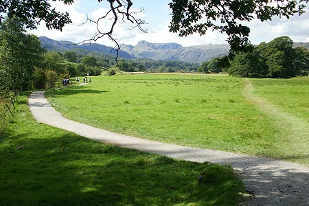
There is a large maple tree outside the Britannia Inn where the walk starts. Follow the Cumbria Way at a left turn just before the bridge over the river. Next, follow the path due south with the river on the right and fields on the left and enter Rob Rash Woods. The lake of Elter Water remains elusively hidden behind trees, until the path emerges from the woods and the view opens out to the right with the lake clearly in view, backed by the Langdale Pikes with Lingmoor Fell on the left. Follow the path ahead, initially across an open field with the River Brathay on the right, then through a gate into woods. The impressive water feature of Skelwith Force soon appears on the right, a rushing waterfall which can be seen from closer to by way of a narrow path leading to a viewing platform. To continue the walk, return to the main path to the small village of Skelwith Bridge where there is a café and a shop (Chesters by the River).
Next cross the A593, the busy main road coming in from the Ambleside direction, and walk up Foul Step, a narrow secondary road ahead that leads to Grasmere which is steep to begin with. After the gradient levels out, take a right turn where the road branches, and then follow a path to the left past houses and along the public bridleway ahead as Loughrigg Tarn comes into view. The Langdale Pikes, one of the most familiar Lakeland mountain profiles, dominate the backdrop to the tarn. Beyond the tarn, the bridleway joins up with a secondary road at a T junction. Turn right here and then take the next path on the left which winds its way up through woodland to Langdale Youth Hostel at High Close. Beyond the hostel, follow the secondary road coming in from Grasmere to the north east past Walthwaite Bottom and back down the hill to the village.
Other walks nearby
| Walk 2715 | Skelwith Bridge & Loughrigg | easy/mod | 5.5 miles |
| Walk 1684 | Lingmoor Fell & Langdale | easy/mod | 7.0 miles |
| Walk 1823 | Fairfield Horseshoe & Loughrigg from High Close | mod/hard | 14.0 miles |
| Walk 1134 | Wetherlam and The Carrs | mod/hard | 10.8 miles |
| Walk 2270 | Tilberthwaite and Holme Fell Little Langdale | easy/mod | 5.5 miles |
| Walk 3697 | Loughrigg Fell from Skelwith Bridge | easy/mod | 4.5 miles |
| Walk 1154 | Between Grasmere and Langdale | moderate | 9.5 miles |
| Walk 1472 | Alcock Tarn & Rydal Water | easy/mod | 7.0 miles |
| Walk 1565 | Rydal Water & Grasmere circular | easy/mod | 6.0 miles |
| Walk 1682 | Rydal Water & Grasmere | easy/mod | 5.5 miles |
Recommended Books & eBooks
Walking the Lake District Fells - Wasdale
 Part of the Walking the Lake District Fells series, this guidebook covers a wide range of routes to 25 Lakeland summits that can be climbed from the Wasdale, Eskdale and Ennerdale valleys, with highlights including Scafell Pike, Great Gable and Pillar. Suggestions for longer ridge routes are also included.
More information
The Cumbria Way
 A guidebook to the 73 mile Cumbria Way, an easy long-distance walk though the heart of the Lake District National Park, from Ulverston in the south to Carlisle in the north, with good transport links to either end. The route is largely low-level but this guide offers alternative mountain days to climb some of the famous fells en route.
More information
Messaging & Social Media
Message Walking Britain and follow the latest news.

Mountain Weather
Stay safe on the mountains with detailed weather forecasts - for iOS devices or for Android devices.