Bleaklow Head from Longdendale
Peak District Walk
Nat Park - Peak District - Bleaklow Longendale
County/Area - Derbyshire
Author - Lou Johnson
Length - 8.0 miles / 13 km Ascent - 2005 feet / 608 metres
Time - 6 hours 0 minutes Grade - moderate
Walk Route Description
Click image to see photo description.
This moorland and edge walk takes you to the high land of Bleaklow in the northern sector of the Peak District National Park. It is best undertaken in fine weather preferably after a dry spell. With poor visibility always a potential hazard, map reading skills and the ability to use a compass are advantageous.
This Peak District walk starts from the car park (grid ref. SK068983) on the south side of the B6105 Glossop to Crowden road adjacent to the Longdendale Trail. There is a National Park Information Centre, toilets and mobile catering at busy periods. From the car park follow the signs and exit onto the Trail. Turn left (north-east) and follow the old railway track bed for approximately one kilometre.
Just before reaching Woodhead Reservoir exit the trail onto the B6105 and head back towards where you started! This may sound odd but it saves some walking on a busy and often unpleasant road. Turn left under railway using the first bridge and follow the track for a short way. Just before crossing the first stream turn right and follow it uphill. There have been reports of wire fences and clay pigeon shooting hereabouts. However note that you are on public access land until nearer the lodge (which is on private land). If you wish to avoid potential confrontation then gain access to Wildboarclough from nearer the start of the walk and join the route as described below the Rollick Stones.
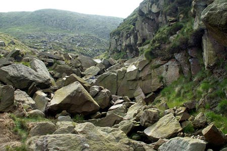
For much of the way there is a path, although in a few places it is hard to see on the ground. The Rollick Stones, which are in view ahead on the edge above, are your target and even if you have lost the path progress is fairly straightforward. Reaching the Rollick Stones follow the clear path around the rim of the edge heading southwards. At this point Wildboar Clough is below on your right. The onward route climbs steadily eventually entering the narrowing clough to follow the eastern side of the stream. The path fades occasionally and to be safe it is a good idea to set a bearing on Bleaklow Head and trust your compass rather than the paths created by lost walkers and sheep!
Although not shown on OS maps there is a path all the way and you will reach the clear route of the Pennine Way (grid ref. 093966). Follow this south to reach Bleaklow Head. A fairly unremarkable spot with a few stones making up a cairn it is better to continue the short distance to the nearby Wain Stones, which provide a better resting place.
Retrace your steps to Bleaklow Head and follow the Pennine Way north. Rather than descend by the outward route we return to Longdendale using the Pennine Way. After passing the point where we joined the Pennine Way the route turns west to follow Wildboar Grain down to John Track Well. Ahead lies the most interesting section of the descent with the path staying on the edge as Torside Clough deepens on your right hand side. Stay with the distinct edge ignoring paths that diverge left over the moor to follow Clough Edge. This is a superb section of path with good views across the valley with the its string of reservoirs to Lad's Leap, Laddow Rocks, Black Hill and the northern moors of the Peak District National Park.
All good things must come to an end and the path descends steeply and passes Reaps Farm to gain the Longdendale Trail. Turn right along this wide path to reach the starting point in a few minutes.
Maps 

| Ordnance Survey Explorer OL1 | Sheet Map | 1:25k | BUY |
| Anquet OS Explorer OL1 | Digital Map | 1:25k | BUY |
| Ordnance Survey Digital Map Subscription | |||
| Latest Ordnance Survey Discounts | |||
Other walks nearby
| Walk 1179 | Lad's Leap & Laddow Rocks from Crowden | moderate | 6.5 miles |
| Walk 2621 | Black Hill & Laddow Rocks | moderate | 9.0 miles |
| Walk 3022 | Black Hill | moderate | 9.0 miles |
| Walk 2375 | The Longendale Edges | mod/hard | 11.8 miles |
| Walk 1168 | Old Glossop & Bleaklow | moderate | 9.5 miles |
| Walk 1759 | Torside Clough & Longendale from Old Glossop | moderate | 7.4 miles |
| Walk 3607 | Reservoirs Walk from Tintwistle | easy/mod | 5.5 miles |
| Walk 3174 | Saltersbrook and Lady Cross from Woodhead | easy/mod | 6.0 miles |
| Walk 1756 | Bleaklow & The Longendale Trail from Woodhead | mod/hard | 10.0 miles |
| Walk 1703 | Longdendale from Hadfield Station | easy/mod | 9.0 miles |
Recommended Books & eBooks
Walking in the Peak District - White Peak East
 Guidebook describing 42 half-day and day walks in the limestone landscapes of Derbyshire's White Peak, part of the Peak District National Park. One of two volumes, this book covers the east of the region, with potential bases including Bakewell, Eyam, Castleton, Birchover, Matlock and Wirksworth.
More information
The Pennine Way - the Path, the People, the Journey
 A portrait of the The Pennine Way, Britain's oldest and best known long-distance footpath, stretching 268 miles from the Peak District to the Scottish Borders. This personal, thoughtful and often humorous story of the path's remarkable history, includes the experiences of walkers and local characters on this exhilarating and complex path.
More information
