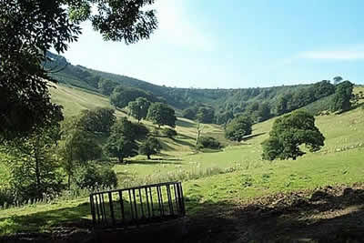
Winsford Hill & the Allotment from Winsford
Exmoor Walk
Nat Park - Exmoor
County/Area - Somerset
Author - Lou Johnson
Length - 6.0 miles / 9.8 km Ascent - 910 feet / 276 metres
Time - 4 hours 0 minutes Grade - moderate
Walk Route Description
Click image to visit gallery of 4 images.
The pleasant village of Winsford is a convenient start with its cafes, pubs and accommodation. The route covers a wide variety of scenic interest and apart from one stiff climb is suitable for walkers of all abilities. Parking is available by the toilets in the centre of the village (Grid ref. SS906350).
The walk starts from the main junction in the village, by the 'Bridge Cottage' tea rooms. Walk west, forking right, over the ford, and follow Ash Lane in the direction of Comers Cross, passing the church on your right. Follow this lane for about 400 metres to locate a footpath sign on the left (Grid ref. 901351). The path goes along a track for a short way before entering meadows. Waymarks help with navigation and you soon arrive at Withycombe Farm and a track. Turn left along this track and start climbing on a bridleway that leads towards Winsford Hill. Ahead and to your left is the Punchbowl - a dramatic natural amphitheatre - which the bridleway skirts on the western edge.
The summit of Winsford Hill is about 300 metres west of the bridleway and can be reached by heading through the heather or more easily by using the paths and tracks that crisscross this area. The summit provides wide ranging panoramas especially north to Dunkery Beacon. Return to the main bridleway that skirts the rim of the Punchbowl and walk east. The track descends gently to reach a metalled lane (grid ref. 892344). Turn right here and walk on the grass verge to reach a cottage - The Folly - after which you take a bridleway that crosses the Allotment. To your left are fine views across the hills and valleys of this very pretty part of the Exmoor National Park.
Stay on the bridleway to reach a disused quarry. Shortly after passing this look out for a footpath sign on your left (grid ref. 905331). This path/bridleway descends quite steeply through pleasant woodland into Yellowcombe. Reaching the stream in the valley floor, cross by the footbridge to reach Yellowcombe Cottage, which has a very secluded location. Climbing northeast along a narrow lane you will soon see the village of Winsford ahead. Reaching a metalled road turn right and within a few minutes you will be back at the start.
Note - although the Landranger map is probably adequate, the Outdoor Leisure map makes navigation much easier especially near to Winsford Hill and across the Allotment.
Maps 

| Ordnance Survey Explorer OL9 | Sheet Map | 1:25k | BUY |
| Anquet OS Explorer OL9 | Digital Map | 1:25k | BUY |
| Ordnance Survey Digital Map Subscription | |||
| Latest Ordnance Survey Discounts | |||
Other walks nearby
| Walk 1220 | Dunkery Beacon | moderate | 8.0 miles |
| Walk 1860 | The River Barle and Withypool from Tarr Steps | easy/mod | 7.5 miles |
| Walk 1669 | Anstey Gate & Hawkridge from Tarr Steps | moderate | 8.2 miles |
| Walk 1750 | Dunkery Beacon (short ascent) | easy/mod | 2.5 miles |
| Walk 2451 | Withypool & Barle Valley | easy/mod | 6.0 miles |
| Walk 2154 | West Anstey Common from Molland | easy/mod | 6.4 miles |
| Walk 3725 | Selworthy Beacon from Selworthy | easy/mod | 5.5 miles |
| Walk 1221 | Selworthy Beacon & North Hill from Bossington | moderate | 8.5 miles |
| Walk 2211 | Minehead to Dunster | easy | 5.0 miles |
| Walk 3386 | Barle Valley & Cow Castle from Simonsbath | easy/mod | 6.4 miles |
