Barle Valley & Cow Castle from Simonsbath
Exmoor Walk
Nat Park - Exmoor
County/Area - Somerset
Author - Lou Johnson
Length - 6.4 miles / 10.4 km Ascent - 900 feet / 273 metres
Time - 4 hours 10 minutes Grade - easy/mod
Walk Route Description
Click image to see photo description.
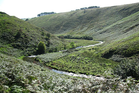
This walk from Simonsbath in the Exmoor National Park explores the upper Barle Valley passing through beautiful scenery. The route follows the Two Moors Way and passes the ruins of Wheal Eliza mine and the impressive Iron Age hillfort of Cow Castle as you make progress down the valley. At the halfway point, the walk turns north to gain higher ground, before heading parallel to the valley through fields allowing you to enjoy some fine moorland scenery.
The start is the Ashcombe car park in Simonsbath (grid ref. SS774394) which lies on the north side of the B3223. After parking, exit the car park, walk down, and turn left along the footpath opposite the inn which is signed to Picked Stones. After 100 metres bear left along the Two Moors Way signed to Cow Castle. The path soon passes Flexbarrow, a small hill on your right, to reach the mine ruins of Wheal Eliza.
The path continues beside the River Barle to pass Cow Castle on your right. If you have time this hillfort is worth exploring. Continue along the Two Moors Way through a gate and across a footbridge to join a track (grid ref. SS797370). Continue ahead along the signed bridleway. The track soon starts to climb to reach a junction (grid ref. SS806364). Turn left following the sign to Picked Stones. After 800 metres, at the next path junction, turn left and continue to a tarmac track where you turn left.
Continue on the bridleway running to the left of Pickedstones Farm. The onward route follows the hedge on your right with a grandstand view down to Cow Castle on your left. Continue following the clear path soon crossing a stream (White Water). Follow the rising track bearing left at a fingerpost to Simonsbath. Follow the path with trees and hedge on your right soon turning right signed to Simonsbath.
Just before reaching Winstitchen Farm, bear left following the bridleway signed to Simonsbath. The path is marked with blue way markers across several fields. Turn left into the wood, again signed to Simonsbath, back to the road where you turn right. The carpark entrance is a short way along the road on your left.
Maps 

| Ordnance Survey Explorer OL9 | Sheet Map | 1:25k | BUY |
| Anquet OS Explorer OL9 | Digital Map | 1:25k | BUY |
| Ordnance Survey Digital Map Subscription | |||
| Latest Ordnance Survey Discounts | |||
Other walks nearby
| Walk 1727 | Shallowford, Hoar Oak Tree & The Chains | moderate | 11.7 miles |
| Walk 2387 | Pinkery Pond Circular | easy/mod | 5.8 miles |
| Walk 2451 | Withypool & Barle Valley | easy/mod | 6.0 miles |
| Walk 1263 | The Doone Valley | moderate | 8.5 miles |
| Walk 1262 | Watersmeet & Foreland Point | mod/hard | 10.5 miles |
| Walk 3729 | Foreland Point | moderate | 5.0 miles |
| Walk 3391 | Valley of Rocks frrom Lynton | easy/mod | 3.8 miles |
| Walk 1910 | Countisbury and Watersmeet from Lynmouth | easy/mod | 4.5 miles |
| Walk 2154 | West Anstey Common from Molland | easy/mod | 6.4 miles |
| Walk 1860 | The River Barle and Withypool from Tarr Steps | easy/mod | 7.5 miles |
