The River Barle and Withypool from Tarr Steps
Exmoor Walk
Nat Park - Exmoor
County/Area - Somerset
Author - Lou Johnson
Length - 7.5 miles / 12.2 km Ascent - 1500 feet / 455 metres
Time - 5 hours 20 minutes Grade - easy/mod
Walk Route Description
Click image to visit gallery of 9 images.
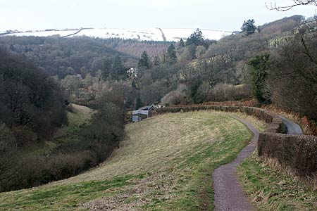
The River Barle is a beautiful river that eventually joins the River Exe south of Dulverton. This walk explores east bank of the river before visiting the attractive village of Withypool. The return route takes to the higher ground offering excellent views over the rolling countryside of this part of the Exmoor National Park. The route is generally well signed and the paths good. However after rain there may be a few muddy sections along the river.
Tarr Steps is located on a minor road between the villages of Hawkridge and Liscombe. Unless you have a high floor 4 wheel drive vehicle the best approach is from Liscombe. This village can be reached from the B3223 Dulverton to Withypool road. The start is the National Park car park above Tarr Steps (Grid ref. SS872323). From here follow the path down to the River Barle. Do not cross the steps and turn right to follow the river upstream. It is worth taking note to see if you can cross the steps as this needs to be done at the end of the walk. If they are impassable then it possible to cross by footbridge further upstream but this adds about 2 km to the walk.
Little in the way of route description is required. All you need to do is follow the river, keeping it on your left, using the clear path. In places you will have to negotiate some muddy sections but these were fairly short in length when the walk was researched. For much of the way to Withypool you are in open woodland interspersed with occasional pasture. Approaching Withypool, the path climbs up the right hand side above the river to join the main road (Grid ref. SS850356). Turn left and walk the short way into the village.
There are a few shops, cafés and a pub, The Royal Oak, which serves good food in an authentic atmosphere. Also of note in the village are the old Shell petrol pumps. Continue through the village across the bridge over the River Barle. Take the first lane on the left and climb steeply out of the village with Withypool Hill to your right. Stay on this undulating lane for over 2 km to Westwater Farm (Grid ref. SS847330). The traffic is generally light and the good view compensate for the tarmac.
Take the bridleway on your left and continue across meadows to Parsonage Farm. Here you go left again and continue down to the lane at Tarr Steps. Cross the steps and walk up past the café back to the car park. Should the stepping stones be impassable then turn left alongside the riverside path and walk upstream for about a kilometre to the footbridge. Cross this and turn right back down to Tarr Steps.
Maps 

| Ordnance Survey Explorer OL9 | Sheet Map | 1:25k | BUY |
| Anquet OS Explorer OL9 | Digital Map | 1:25k | BUY |
| Ordnance Survey Digital Map Subscription | |||
| Latest Ordnance Survey Discounts | |||
Other walks nearby
| Walk 1222 | Winsford Hill & the Allotment | moderate | 6.0 miles |
| Walk 2154 | West Anstey Common from Molland | easy/mod | 6.4 miles |
| Walk 2451 | Withypool & Barle Valley | easy/mod | 6.0 miles |
| Walk 1220 | Dunkery Beacon | moderate | 8.0 miles |
| Walk 1750 | Dunkery Beacon (short ascent) | easy/mod | 2.5 miles |
| Walk 3386 | Barle Valley & Cow Castle from Simonsbath | easy/mod | 6.4 miles |
| Walk 3725 | Selworthy Beacon from Selworthy | easy/mod | 5.5 miles |
| Walk 1221 | Selworthy Beacon & North Hill from Bossington | moderate | 8.5 miles |
| Walk 1727 | Shallowford, Hoar Oak Tree & The Chains | moderate | 11.7 miles |
| Walk 2387 | Pinkery Pond Circular | easy/mod | 5.8 miles |
