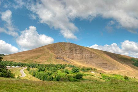
Mam Tor, Upper Booth & Rushup Edge from Mam Nick
Peak District Walk
Nat Park - Peak District - Great Ridge Castleton
County/Area - Derbyshire
Author - Lou Johnson
Length - 7.0 miles / 11.4 km Ascent - 1200 feet / 364 metres
Time - 4 hours 40 minutes Grade - moderate
Walk Route Description
Click image to see photo description.
This Peak District walk explores some of the highlights of Edale and its surrounding hills. The walk includes the well known viewpoint of Mam Tor and the adjoining Castleton Ridge. The walk then descends into Edale and explores some less walked paths before climbing onto Rushup Edge at the end of the route.
The walk starts in the large pay and display car park (grid ref. SK123832) just south of Man Nick, near Castleton. There is also come on-road parking in the vicinity if you want to avoid the parking charge. Exit the car park to the north climbing the steps and follow the clear path up to Mam Nick to reach the road.
Bear right and continue to climb the steps and path leading to the summit of Mam Tor from where there are substantial views across the surrounding area. The view north towards Edale and the Kinder Plateau is of particular interest as you will be traversing some of this area as the walk proceeds. Continue along the Castleton Ridge descending along the clear path to reach Hollin's Cross (grid ref. SK135845).
Turn left here, taking the left hand path downwards and following the sign to Barber Booth. Initially the path descends quite quickly but becomes less steep as you lose height. The route runs to the north of Greenlands to join a lane. Turn right and walk north towards Edale. The lane bears right and just afterwards take the stile on the left (grid ref. SK123846). The path crosses a number of fields using stiles and gates, eventually reaching a road (grid ref. SK113846).
At the road, go right. This leads you to the hamlet of Barber Booth. Take the first track on the left and follow this over the railway (grid ref. SK111848). The track bears left over the railway and follow the sometimes feint route, Where the path is unclear head for the farm buildings ahead to reach Upper Booth (grid ref. SK102853). Turn left in the hamlet and then right onto the Pennine Way following in towards Jacob's ladder. Just before Lee House, look for gate below a grassy area on left hand side (grid ref. SK097854). Follow the path towards Highfield heading south at grid ref. SK101850 towards Dale Head.
From Dale Head continue in a southerly direction following the sign to Whitemoor Clough. A steep climb lies ahead onto Rushup Edge. When the path flattens out (grid ref. SK099829), turn left and follow the edge eastwards to Reach Mam Nick. Follow the path and steps down to the car park.
Maps 

| Ordnance Survey Explorer OL1 | Sheet Map | 1:25k | BUY |
| Anquet OS Explorer OL1 | Digital Map | 1:25k | BUY |
| Ordnance Survey Digital Map Subscription | |||
| Latest Ordnance Survey Discounts | |||
Other walks nearby
| Walk 1688 | Old Dam & Sparrowpit from Mam Nick | moderate | 9.0 miles |
| Walk 1159 | Grindsbrook & Edale Head | moderate | 7.5 miles |
| Walk 1264 | Rushup Edge & Crowden Tower | moderate | 10.0 miles |
| Walk 1295 | Ringing Roger & Edale Cross | moderate | 10.0 miles |
| Walk 2595 | Castleton Great Ridge from Edale | moderate | 8.5 miles |
| Walk 2615 | The Kinder Edges | mod/hard | 18.0 miles |
| Walk 3350 | Kinder Scout Summit | moderate | 8.5 miles |
| Walk 1113 | Ringing Roger & Grindslow Knoll | moderate | 5.5 miles |
| Walk 1300 | Hope Cross & Ringing Roger | moderate | 8.0 miles |
| Walk 2378 | Rushup Edge & Mam Tor | moderate | 10.0 miles |
Recommended Books & eBooks
Great Mountain Days in the Pennines
 An inspirational guidebook to 50 classic walks on the rolling Pennine landscape. The graded routes, between 6 and 13 miles in length, cover classic Pennine fells and moorland such as Whernside, Ilkley Moor and Pendle Hill; exploring the North and South Pennines, Yorkshire Dales, Howgills and Dark Peak. Many routes are also suited to fell running.
More information
Dark Peak Walks
 Guidebook to 40 walks in the Dark Peak area of the Peak District National Park. 35 circular routes for most abilities, from 8km to 19km, around Edale, Marsden, Fairholmes, Baslow and Castleton, including Kinder Scout and Mam Tor, and 5 longer (25km to 45km) routes highlighting the best of the Gritstone Edges, High Moorland and Deep Valleys.
More information
