Hope Cross & Ringing Roger from Edale
Peak District Walk
Nat Park - Peak District - Kinder Scout Edale
County/Area - Derbyshire
Author - Lou Johnson
Length - 8.0 miles / 13 km Ascent - 1700 feet / 515 metres
Time - 5 hours 40 minutes Grade - moderate
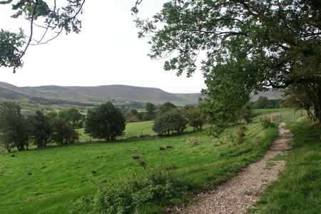
Walk Route Description
Click image to visit gallery of 9 images.
This Peak District walk explores the quieter eastern section of the Kinder Plateau. The route starts from the main car park in Edale (grid ref. SK124853). There is also a public transport option with Edale station served by trains on the Manchester and Stockport to Sheffield route. The walk begins by using field paths linking the farms of the Edale Valley before climbing onto the moors of Kinder.
Exit the car park and walk north into the village. Go past the campsite and the National Park information centre on your right and then take the signed footpath to Ollerbrook Booth, which also on your right. Follow the waymarked route through the buildings at Ollerbrook Booth and, still heading east, cross more fields on the path to Nether Booth Farm. After passing Cotefield (on your left) turn left at the footpath junction (grid ref SK133859). This leads you uphill with the path following the edge of Open Country to reach the Youth Hostel at Rowland Gate (grid ref SK140865). Signs direct you on to the path towards Clough Farm, where some careful navigation is required to stay on the route. As a general comment bear left and providing you stay on a path you can't really go too wrong.
The path climbs again to enter Open Country and continues its ascent across open moorland to enter Jagger's Clough. Continue on the main track to climb up onto the ridge linking Win Hill with the Kinder Plateau (grid ref SK159876). From here you get your first view north towards the Derwent Valley and the surrounding high moorland. You can make a short diversion south to Hope Cross, which stands on the route of the old Roman road that originally linked Hope to Glossop. There are a number of paths at this important junction and it is important that you locate the right one, which is the clear track heading northwest onto Crookstone Hill.
The track soon reduces to a footpath, which turns southwest across Crookstone Out Moor becoming a well trodden path along the southern edge of Kinder. The views across Edale to the Castleton Ridge are excellent. The going is fairly level and you need to have map in hand ready to identify where you cross Ollerbrook Clough (grid ref. SK129874). Since the OS 1:25000 map was surveyed a number of additional fences have been constructed in this vicinity so careful navigation is necessary. However the general aim is to leave the edge path as it continues towards Golden Clough and Grindsbrook, and follow the small ridge southwest to the rocky prominence of Ringing Roger (grid ref. SK125872). This is best by keeping to the ridge and using the stiles to cross the new fences.
From Ringing Roger you get a bird's eye view of Grindsbrook and Edale. You can also plot your route into the valley as the path used for the descent as it zigzags down to the Nab and continues into the Grindsbrook valley. Once you join the main valley path, bear left, cross the footbridge, pass the Old Nags Head (the start or finish of the Pennine Way) and follow the lane back down to the start.
Maps 

| Ordnance Survey Explorer OL1 | Sheet Map | 1:25k | BUY |
| Anquet OS Explorer OL1 | Digital Map | 1:25k | BUY |
| Ordnance Survey Digital Map Subscription | |||
| Latest Ordnance Survey Discounts | |||
Other walks nearby
| Walk 2522 | Rushup Edge & Edale from Mam Nick | moderate | 7.0 miles |
| Walk 1368 | Mam Tor, Upper Booth & Rushup Edge | moderate | 7.0 miles |
| Walk 1831 | Mam Tor & Hollins Cross from Mam Nick | easy | 3.0 miles |
| Walk 1688 | Old Dam & Sparrowpit from Mam Nick | moderate | 9.0 miles |
| Walk 1087 | Mam Tor & Cave Dale | moderate | 6.5 miles |
| Walk 1519 | Catleton & Speedwell Cavern Circular | easy | 4.3 miles |
| Walk 1521 | Cave Dale and Winnats Pass | easy | 4.5 miles |
| Walk 1665 | Hollins Cross & Lose Hill | easy/mod | 6.0 miles |
| Walk 3426 | Lose Hill & Hollins Cross | easy/mod | 5.0 miles |
| Walk 1489 | Blackden Brook, Kinder & Upper Ashop | moderate | 6.8 miles |
Recommended Books & eBooks
Walking in Derbyshire
 Walking guidebook to 60 circular day walks in Derbyshire and the Peak District. Includes the Derwent, Wye and Trent river valleys, near Derby, Matlock, Glossop, Bakewell and Ripley. Routes range from easy to moderate and are between 4 and 14km (2 to 10 miles). Walks focus on places of interest, from Stone Age forts to castles to grand estates.
More information
Dark Peak Walks
 Guidebook to 40 walks in the Dark Peak area of the Peak District National Park. 35 circular routes for most abilities, from 8km to 19km, around Edale, Marsden, Fairholmes, Baslow and Castleton, including Kinder Scout and Mam Tor, and 5 longer (25km to 45km) routes highlighting the best of the Gritstone Edges, High Moorland and Deep Valleys.
More information
