Grindsbrook & Edale Head from Edale
Peak District Walk
Nat Park - Peak District - Kinder Scout Edale
County/Area - Derbyshire
Author - Lou Johnson
Length - 7.5 miles / 12.2 km Ascent - 1520 feet / 461 metres
Time - 5 hours 20 minutes Grade - moderate
Walk Route Description
Click image to visit gallery of 5 images.
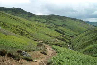
The Kinder Plateau provides a wonderful excuse for putting on your walking boots. The walk from the main car park in Edale (grid ref. SK124853) and for once there is a viable public transport option with Edale station served by trains on the Manchester and Stockport to Sheffield route. The walk itself follows the Grindsbrook valley to reach the edge of of Kinder. The route continues along the edge to reach Edale Head and a descent along the Pennine Way back to the start.
Parking in Edale can be a problem especially at weekends and in fine weather so an early start is probably a good idea. From the car park (or station) head north into the village passing an excellent Tourist Information Centre on the right hand side of the lane. Continuing on the road you reach the Nag's Head pub, the official start or end of the Pennine Way. Shortly after the pub the way-marked footpath turns right and descends to cross Grinds Brook. The path soon divides and you should stay on the paved valley path as it heads into the narrowing Grindsbrook Clough. On your right the gritstone edges provide a clear idea of how high you need to climb.
As you continue further up Grindsbrook the valley narrows, the paved path finishes and the route becomes more interesting. The higher you climb, the rougher the path although nowhere can it be classed as difficult. As you near the top of the Clough it swings right to enter a mini-gorge. Instead of following the stream, keep straight on and climb up on to the plateau. It is a little rough and some handwork may be necessary. The climbing now over, you will find plenty of rocks on which to rest - perhaps watching fellow walkers struggle up the last few feet onto Kinder's wild moorland plateau.
In poor visibility, Kinder can be a confusing place to be and accurate compass work is essential. However if you are blessed with fine weather the high level walking is a pleasure with good views to your left. Occasional boggy sections can be an annoyance but with care dry feet should be maintained with off-path diversions. Leaving the original route of the Pennine Way you head west. The start of the path is a little uncertain leaving Grindsbrook Clough but once located is easy to follow. In contrast to the close confines of Grindsbrook Clough you now have the benefit of open upland with interest added to the walk by the numerous exposed eroded rocks that litter the landscape. Many have interesting names although it is sometimes hard to establish how they came about.
Keeping in a westerly direction you reach Crowden Tower, shortly followed by the Wool Packs. Crossing Edale Head, you will see Edale Rocks, below which the path contours to reach the broad col just to the east of Edale Cross. The latter antiquity is worth a diversion if you have time and indicates how long the next section of the walk has been used as a trade route. From here back to Edale you follow the current route of the Pennine Way and as expected it is well maintained and easy walking. Turning east there is a steep descent down Jacob's Ladder, which once saw regular pack horse traffic, to reach a pretty stone bridge across the infant River Noe.
The final section of the route is easy walking. The next objective is Upper Booth farm where the path enters the farmyard with clear signs indicating the onward route to Edale. To your left there are excellent views of Crowden Clough while on the right Rushup Edge, Mam Tor and the Castleton Ridge provide a wonderful panorama. Crossing fields you soon reach the Nag's Head with a stroll down the lane to your car completing the walk.
Maps 

| Ordnance Survey Explorer OL1 | Sheet Map | 1:25k | BUY |
| Anquet OS Explorer OL1 | Digital Map | 1:25k | BUY |
| Ordnance Survey Digital Map Subscription | |||
| Latest Ordnance Survey Discounts | |||
Other walks nearby
| Walk 2522 | Rushup Edge & Edale from Mam Nick | moderate | 7.0 miles |
| Walk 1368 | Mam Tor, Upper Booth & Rushup Edge | moderate | 7.0 miles |
| Walk 1831 | Mam Tor & Hollins Cross from Mam Nick | easy | 3.0 miles |
| Walk 1688 | Old Dam & Sparrowpit from Mam Nick | moderate | 9.0 miles |
| Walk 1087 | Mam Tor & Cave Dale | moderate | 6.5 miles |
| Walk 1519 | Catleton & Speedwell Cavern Circular | easy | 4.3 miles |
| Walk 1521 | Cave Dale and Winnats Pass | easy | 4.5 miles |
| Walk 1665 | Hollins Cross & Lose Hill | easy/mod | 6.0 miles |
| Walk 3426 | Lose Hill & Hollins Cross | easy/mod | 5.0 miles |
| Walk 1489 | Blackden Brook, Kinder & Upper Ashop | moderate | 6.8 miles |
Recommended Books & eBooks
Great Mountain Days in the Pennines
 An inspirational guidebook to 50 classic walks on the rolling Pennine landscape. The graded routes, between 6 and 13 miles in length, cover classic Pennine fells and moorland such as Whernside, Ilkley Moor and Pendle Hill; exploring the North and South Pennines, Yorkshire Dales, Howgills and Dark Peak. Many routes are also suited to fell running.
More information
The Pennine Way
 Guidebook to the Pennine Way National Trail with OS map booklet. The 265 mile route from Edale to Kirk Yetholm takes three weeks to walk and is suitable for fit and experienced long distance walkers. The route crosses the Peak District, Yorkshire Dales and North Pennines National Parks. Includes separate OS 1:25,000 map booklet of the route.
More information
