Swyre Head & Tyneham Cap from Kimmeridge
Jurassic Coast Walk
Region - Jurassic Coast
County/Area - Dorset
Author - Lou Johnson
Length - 11.8 miles / 19.1 km Ascent - 1400 feet / 424 metres
Time - 7 hours 20 minutes Grade - moderate
Maps 

| Ordnance Survey Explorer OL15 | Sheet Map | 1:25k | BUY |
| Anquet OS Explorer OL15 | Digital Map | 1:25k | BUY |
| Ordnance Survey Landranger 194 | Sheet Map | 1:50k | BUY |
| Anquet OS Landranger 194 | Digital Map | 1:50k | BUY |
Walk Route Description
Click image to see photo description.
This walk combines dramatic seascapes with the more rural landscapes in land. The route passes one of Britain's few land based oil wells and includes a section of the South West Coast Path. Sections of this walk are close to firing ranges and you are advised to take heed of all warnings in respect of path closures. In addition it is recommended you stay on marked paths and do not touch any suspicious objects that you might find. There is also restricted access so please check Range Opening Times.
The start is the small car park located in a quarry above the village of Kimmeridge (Grid ref. SY918800). After parking, take the signed bridleway on the northern side of the quarry that rises gently in south-easterly direction along a ridge onto Smedmore Hill. The bridleway continues in a similar direction to the trig point on Swyre Head (203 metres above sea level).
From Swyre head the route initially swings north following a bridleway past Polar Wood to reach a tarmac lane (grid ref. SY943792). Bear right along the lane and walk towards the village of Kingston (where there is a pub slightly off route). Reaching the Plantation car park (grid ref. SY953795) turn right down the signed footpath that leads down to the coast at Houns-tout Cliff.
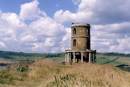
Reaching the coast turn right along the South West Coast Path. You walk past the Kimmeridge Ledges to reach the Clavell Tower and Kimmeridge Bay. Stay on the South West Coast Path past the oil wells and up to the eastern end of Gad Cliff (grid ref. SY888797). Turn right here and ascend Tyneham Cap continuing by following the track ahead which descends to reach a bridleway at grid ref. SY905802. Here take the bridleway straight ahead which leads back to the car park from where the walk started.
Other walks nearby
| Walk 2145 | Houns-tout Cliff from Kingston | easy | 3.5 miles |
| Walk 2568 | Egmont Point & Kimmeridge Bay from Tyneham | moderate | 14.0 miles |
| Walk 1533 | Gad Cliff, Povington Hill & Tyneham | easy/mod | 4.5 miles |
| Walk 2925 | St Aldhelm's Head near Worth Matravers | easy | 4.1 miles |
| Walk 3286 | Dancing Ledge & Durlston Head from Langton Matravers | easy/mod | 7.0 miles |
| Walk 1004 | Durdle Door & Lulworth Cove | easy | 2.5 miles |
| Walk 1329 | Durdle Door & White Nothe from Lulworth Cove | moderate | 7.0 miles |
| Walk 3389 | Bindon Hill and the Fossil Forest from Lulworth | easy/mod | 4.0 miles |
| Walk 2579 | Purbeck Coast from Swanage | moderate | 10.0 miles |
| Walk 1634 | Old Harry & Ballard Down from Studland | easy/mod | 5.3 miles |
Recommended Books & eBooks
South West Coast Path Map Booklet - Minehead to St Ives
 Map of the northern section of the 630 mile (1014km) South West Coast Path National Trail. Covers the trail from Minehead to St Ives along the north Devon and Cornish coastline. This convenient and compact booklet of Ordnance Survey 1:25,000 maps shows the route, providing all of the mapping you need to walk the trail in either direction.
More information
South West Coast Path Map Booklet - St Ives to Plymouth
 Map of part of the southern section of the 630 mile (1014km) South West Coast Path National Trail. Covers the trail from St Ives to Plymouth along the west Cornwall and Devon coastline. This convenient and compact booklet of Ordnance Survey 1:25,000 maps shows the route, providing all of the mapping you need to walk the trail in either direction.
More information
Messaging & Social Media
Message Walking Britain and follow the latest news.

Mountain Weather
Stay safe on the mountains with detailed weather forecasts - for iOS devices or for Android devices.