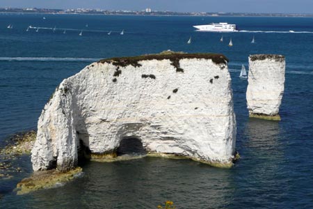
Studland & Old Harry Rocks from Sheel Bay
Jurassic Coast Walk
Region - Jurassic Coast
County/Area - Dorset
Author - Pia Barratt
Length - 8.5 miles / 13.8 km Ascent - 250 feet / 76 metres
Time - 4 hours 30 minutes Grade - easy/mod
Walk Route Description
Click image to visit gallery of 2 images.
The Jurassic Coast stretches from Old Harry Rock, included in this walk, west to Orcombe Point near Exmouth a distance of some 95miles. Following the coast is the South West Coast Path which starts, or finishes depending on your view, at Poole Harbour and continues round the English Coast to Minehead in Somerset. This walk enjoys both and offers a pleasant walk along the seaside with views inland to rural Dorset and Poole Harbour.
The walk starts at the car park (grid ref SZ035862) by the roundabout on the B3351 that leads to the ferry across Poole Harbour to Sandbanks. After parking it is suggested you walk along the road to the ferry so that you can say you have actually started from the official beginning of the South West Coast Path. So, with the sea on your left, walk along the beach of Shell Bay. Continue along the beach passing into Studland Bay. Please note that this takes walkers through a nudist beach.
From Studland Beach, continue following the South west Coast Path up to Studland Village where refreshment may be taken at the Banks Arms pub. This pub is cosy and well decorated inside and has a large field/pub garden overlooking the sea and cliffs where lunch is served in good weather. The path continues up a gradual gradient to the cliff edge. Heading west you get a fine view down on Studland Bay and east along the coast into Hampshire.
Once on the cliff top path, you have excellent seascapes to the left with a pleasant rural outlook to you right with rolling downland. Quite soon you reach The Foreland (or Handfast Point) from where you get a bird's eye view of Old Harry Rock. Turning the corner the view includes the coast to Swanage and beyond. If you are feeling energetic the path may be followed from here to Swanage and beyond, past the crumbling stacks and archways that line this past of the coast. To return to the start simply retrace your steps.
Maps 

| Ordnance Survey Explorer OL15 | Sheet Map | 1:25k | BUY |
| Anquet OS Explorer OL15 | Digital Map | 1:25k | BUY |
| Ordnance Survey Digital Map Subscription | |||
| Latest Ordnance Survey Discounts | |||
Other walks nearby
| Walk 1634 | Old Harry & Ballard Down from Studland | easy/mod | 5.3 miles |
| Walk 3396 | Agglestone & Old Harry Rocks | easy/mod | 6.4 miles |
| Walk 3286 | Dancing Ledge & Durlston Head from Langton Matravers | easy/mod | 7.0 miles |
| Walk 2579 | Purbeck Coast from Swanage | moderate | 10.0 miles |
| Walk 2145 | Houns-tout Cliff from Kingston | easy | 3.5 miles |
| Walk 2925 | St Aldhelm's Head near Worth Matravers | easy | 4.1 miles |
| Walk 1331 | Kimmeridge & Tyneham | easy/mod | 6.8 miles |
| Walk 1534 | Swyre Head & Tyneham Cap from Kimmeridge | moderate | 11.8 miles |
| Walk 1995 | Houns-tout & Swyre Head from Kimmeridge | moderate | 8.7 miles |
| Walk 2568 | Egmont Point & Kimmeridge Bay from Tyneham | moderate | 14.0 miles |
Recommended Books & eBooks
The South West Coast Path
 Guidebook to walking the entire South West Coast Path National Trail. The route runs for 630 miles from Minehead to Poole along the north Devon, Cornish, south Devon and Dorset coastline. Divided into 45 stages, this long-distance coastal trek could be completed within 4 weeks, or walked in sections. Guide includes maps and essential information.
More information
South West Coast Path Map Booklet - Minehead to St Ives
 Map of the northern section of the 630 mile (1014km) South West Coast Path National Trail. Covers the trail from Minehead to St Ives along the north Devon and Cornish coastline. This convenient and compact booklet of Ordnance Survey 1:25,000 maps shows the route, providing all of the mapping you need to walk the trail in either direction.
More information
