Bignor Hill and The Denture from Amberley
South Downs Walk
Nat Park - South Downs
County/Area - West Sussex
Author - Lou Johnson
Length - 8.7 miles / 14.1 km Ascent - 1000 feet / 303 metres
Time - 5 hours 20 minutes Grade - moderate
Walk Route Description
Click image to see photo description.
This South Downs walk includes parts of both the South Downs Way and the Monarch's Way. The route includes a mixture of fields, woodland, a few hills up and down. After wet weather the paths can be quite muddy. Care is also needed crossing a busy main road. Route finding is generally easy.
The start and finish point is Amberley station. After crossing the main road and going left under the railway bridge, the first turning on the right leads over a wooden stile to the River Arun. Cross the footbridge over the river on the left and then follow the waymarked signs for the South Downs Way. Once the path gains some height, there is a view looking back towards the River Arun and the footbridge and a stretch of the South Downs ridge to the east of Amberley. After crossing the busy A29 there are no more roads to cross for a few miles as the route heads north-west between fields.
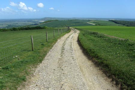
The next dip marks a crossroads of paths near to Westburton Hill and then the next stretch is quite steep going up south west before turning north-west on the way towards Bignor Hill with its two radio stations. Looking back, you can see the path you have just come along across the valley to the east. The path does not go to the top of Bignor Hill but skirts round to the left of it and leads to a car park.
Turn left here off the South Downs Way and head the short distance south to meet the Monarch's Way. Turn left onto this long distance path and continue through woodland along "The Denture" and through Houghton Forest. Once the path crosses the main road (A29) it crosses alongside a field with a view overlooking Amberley. Rather than walk along the road turn left in Houghton (grid ref. TQ018115) and walk north to rejoin the South Downs Way used earlier. A footpath to the right leads back to the bridge over the river and then back to Amberley railway station.
Maps 

| Ordnance Survey Explorer OL10 | Sheet Map | 1:25k | BUY |
| Anquet OS Explorer OL10 | Digital Map | 1:25k | BUY |
| Ordnance Survey Digital Map Subscription | |||
| Latest Ordnance Survey Discounts | |||
Other walks nearby
| Walk 3305 | Amberley Mount and Wepham Down | easy/mod | 8.0 miles |
| Walk 1667 | Blackpatch Hill & Harrow Hill from near Storrington | easy/mod | 7.2 miles |
| Walk 3464 | Rackham Hill & Kithurst Hill Circular | easy/mod | 6.7 miles |
| Walk 3080 | Arundel Park and the River Arun | easy/mod | 7.2 miles |
| Walk 2835 | Arundel to Amberley | easy | 6.2 miles |
| Walk 1423 | Midhurst Way - Arundel to Midhurst | mod/hard | 19.0 miles |
| Walk 3310 | Washington to Littleton Farm by the South Downs Way | moderate | 13.0 miles |
| Walk 3078 | Cissbury Ring & Chanctonbury Ring from Washington | easy/mod | 8.3 miles |
| Walk 2487 | Littlehampton to Climping | easy | 5.0 miles |
| Walk 1425 | Midhurst Way - Petworth to Midhurst | easy/mod | 5.5 miles |
Recommended Books & eBooks
The South Downs Way
 Guidebook to walking the South Downs Way National Trail, a 100 mile (160km) route between Winchester and Eastbourne through the South Downs National Park, described in both directions over 12 stages. Easy walking on ancient and historical tracks, taking in wooded areas, delightful river valleys and pretty villages. With 1:25K OS map booklet.
More information
Walks in the South Downs National Park
 Guidebook with 40 circular walks throughout the South Downs National Park, exploring the beautiful chalk hills between Eastbourne and Winchester. The walks range from under 5 miles to 11 miles, including Beachy Head and the Seven Sisters, Ditchling Beacon and hundreds of prehistoric sites. Accessible all year, but wild flowers best in spring.
More information
