Henley-on-Thames to Marlow along the Thames Path
Oxfordshire Walk
County/Area - Oxfordshire & Berkshire & Buckinghamshire
Author - Lou Johnson
Length - 9.0 miles / 14.6 km Ascent - 120 feet / 36 metres
Time - 4 hours 40 minutes Grade - easy/mod
Walk Route Description
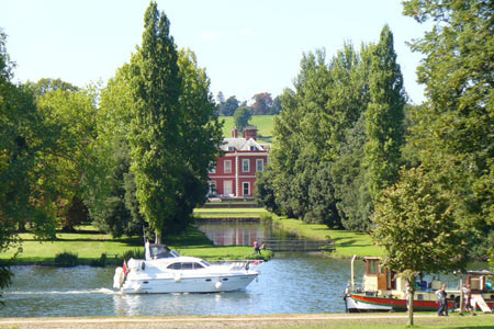
Click image to see photo description.
The Thames Path National Trail was first proposed in 1948 and eventually opened in 1996. It follows the length of the River Thames from its source near Kemble in Gloucestershire to the Thames Barrier at Charlton. Total length is approximately 184 miles with a considerable proportion of the path using the original towpath. This walk concentrates on the section downstream from Henley-on-Thames through to Marlow and follows a linear route. You could either use two cars, the regular bus service between the start and end or use the rail services out of London.
The start (grid ref. SU763826) is the bridge over the Thames at eastern end of Hart Street (A4130). Cross the bridge to eastern bank and, following the signs, turn left almost immediately. This takes you down to the riverbank. Walk north with the river to your left. You soon reach Remenham with Fawley Court College across the river to your left. Continuing north you pass Temple Island before the river turns south-east to reach Hambledon Lock.
Continuing on the Thames Path you reach Aston where the path turns inland (grid ref. SU786844). Turn right down the lane and proceed into Aston. Just past the road junction, turn left down the access to Holme Farm. Continue past this farm and following the clearly signed path continue until just before Lower Culham Farm, where you turn sharp left to reach the riverside again.
The route ahead needs little description and Hurley Lock is the next key objective. Here turn left over the bridge, walk along the 'island' passing the locks. Ignore the footbridge immediately after the locks and continue ahead to reach another footbridge that allows you to regain the riverside path (grid ref. 828843) on the south side of the river. Continue for approximately 600 yards to turn left over a long footbridge (grid ref. SU834843) to gain the north bank of the river. All that remains is a pleasant mile and half walk into Marlow and the end of the walk.
Maps 

| Ordnance Survey Explorer 171 | Sheet Map | 1:25k | BUY |
| Anquet OS Explorer 171 | Digital Map | 1:25k | BUY |
| Ordnance Survey Explorer 172 | Sheet Map | 1:25k | BUY |
| Anquet OS Explorer 172 | Digital Map | 1:25k | BUY |
| Ordnance Survey Digital Map Subscription | |||
| Latest Ordnance Survey Discounts | |||
Other walks nearby
| Walk 2051 | River Thames & Hambleden from Henley-on-Thames | easy/mod | 7.0 miles |
| Walk 3128 | Henley-on-Thames, Aston and Hambleden | easy/mod | 8.0 miles |
| Walk 3248 | Henley-on-Thames, Rotherfield Greys & Shiplake | easy/mod | 8.3 miles |
| Walk 1919 | Henley-on-Thames, Middle Assendon and Stonor | moderate | 14.5 miles |
| Walk 1954 | Fingest & Turville from Hambleden | moderate | 11.4 miles |
| Walk 1966 | Turville & Hambleden circular | moderate | 9.6 miles |
| Walk 3082 | Sonning Eye & Shiplake circular | easy | 5.7 miles |
| Walk 1982 | Hurley Circular | easy | 5.1 miles |
| Walk 2398 | Turville Circular | easy | 4.1 miles |
| Walk 3359 | Christmas Common, Ibstone Common & Turville Heath | easy/mod | 8.5 miles |
Recommended Books & eBooks
The Thames Path Map Booklet
 Map of the 180 mile (288km) Thames Path National Trail, from London's Thames Barrier to the river's source near Cirencester in Gloucestershire. This booklet is included with the Cicerone guidebook to the trail, and shows the full route on OS 1:25,000 maps. The easy riverside route takes around two weeks to walk.
More information
