Turville & Hambleden circular
Chilterns Walk
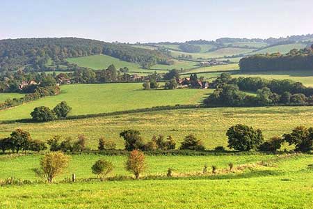
Region - Chilterns
County/Area - Buckinghamshire - South Buckinghamshire
Author - Lou Johnson
Length - 9.6 miles / 15.6 km Ascent - 1050 feet / 318 metres
Time - 5 hours 50 minutes Grade - moderate
Walk Route Description
Click image to see photo description.
Circular walk from Hambleden in the Chilterns. The route uses sections of Shakespeare's Way and the Chiltern Way to explore an area of rolling hills with a patchwork of pastures and woodland. The walk also visits the charming village of Turville as well as passing through other settlements. This area has featured in many films and TV programmes with its quintessential English landscape.
The start is the village green in Hambleden (grid ref. SU784865) where limited on-street parking is available. On busy days expect parking to be at a premium. After parking, face the parish church and turn left in front of a fine terrace of houses. Follow the lane around to the right and continue ahead to take the second footpath on the right (grid ref. SU782867). Walk half left across the field to join Skirmett Road at a stile. Turn right and continue for 300 metres and turn left onto a track (part of Shakespeare's Way). At the first junction keep right and continue through trees to reach open fields. Re-entering woodland the path soon turns right.
Continue through woodland for 1.5 kilometres to exit into open countryside. The onward path keeps on the right-hand side of two fields to join a track which leads between the buildings of Upper Woodend Farm to reach a lane (grid ref. SU758883). Bear right along the lane and continue to a T-junction. Take the stile opposite, crops a field into woodland. Ignore a cross-track and continue ahead soon emerging from the trees. After 300 metres fork left just before a group of trees and follow the path which soon joins a track that leads to a road (grid ref. SU752897).
Turn right towards Southend and turn right at the first junction. You are now following the Chiltern Way all the way back to Hambleden. Continue ahead passing Southend Farm on your right. Reaching the end of the tarmac join the track ahead. Descend the track briefly passing through woodland to reach Dolesden Lane (grid ref. SU763904). Cross the lane and continue on the rising track. Ignore paths right and left and continue to the green Turville. Cross the green to a track between houses with adjacent fingerpost. After a short distance turn right along the Chiltern Way. The route crosses a field and then runs along the edge of a small wood to reach Oxford Road. Go straight across into trees and fork right to follow the path into Fingest (grid ref. SU777911).
Walk into the village passing the Chequers Inn on your right. Continue past the last house on the right and turn right onto the signed path. The path stays on the right-hand side of the field, bears left beside a wood before veering right through trees. Cross a small field, ren-enter woodland and shortly after turn right (grid ref. SU785908). Follow the meandering path downhill to reach open country. Nearing a lane, the path forks right, crossing fields to just before Skirmett where the route turns sharp left with fence on your left to reach Shogmoor Lane (grid ref. SU778899).
Turn right and take the first footpath on the left. Heading south across fields the path soon passes Arizona Farm on your right. Maintain direction across fields to reach a lane near Colstrope Farm. Bear right and then take the first path on the left. The route continues across fields to pass the rear of houses at Pheasant's Hill. A further section across fields leads ta a road at Hambleden (grid ref. SU783687). Turn left and continue into the centre of Hambleden.
Maps 

| Ordnance Survey Explorer 171 | Sheet Map | 1:25k | BUY |
| Anquet OS Explorer 171 | Digital Map | 1:25k | BUY |
| Ordnance Survey Digital Map Subscription | |||
| Latest Ordnance Survey Discounts | |||
Other walks nearby
| Walk 1954 | Fingest & Turville from Hambleden | moderate | 11.4 miles |
| Walk 1720 | Henley-on-Thames to Marlow along the Thames Path | easy/mod | 9.0 miles |
| Walk 2051 | River Thames & Hambleden from Henley-on-Thames | easy/mod | 7.0 miles |
| Walk 1919 | Henley-on-Thames, Middle Assendon and Stonor | moderate | 14.5 miles |
| Walk 3128 | Henley-on-Thames, Aston and Hambleden | easy/mod | 8.0 miles |
| Walk 3248 | Henley-on-Thames, Rotherfield Greys & Shiplake | easy/mod | 8.3 miles |
| Walk 1982 | Hurley Circular | easy | 5.1 miles |
| Walk 2398 | Turville Circular | easy | 4.1 miles |
| Walk 1965 | Piddington & Horsleys Green Circular | easy | 4.9 miles |
| Walk 2470 | West Wycombe & Bledlow Ridge | moderate | 8.2 miles |
