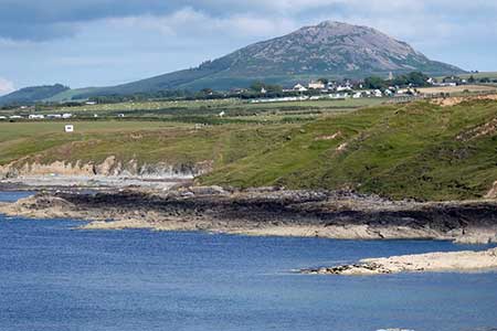
Garn Bach & Carn Fadryn
Llyn Peninsula Walk
Region - Llyn Peninsula
County/Area - Gwynedd - Llyn Peninsula
Author - Lou Johnson
Length - 5.0 miles / 8.1 km Ascent - 1100 feet / 333 metres
Time - 3 hours 40 minutes Grade - easy/mod
Walk Route Description
Click image to see photo description.
Starting from the village of Garnfadryn fine miles north of Abersoch, this circular walk explores the countryside and also climbs Garn Bach and Carn Fadryn which both provide excellent views over the Llyn Peninsula. Carn Fadryn also has evidence of a hill fort which is also worth exploring. The route follows paths and tracks with a steep climb at the end of the walk to the summit of Carn Fadryn.
The start is the roadside parking area to the west of the old chapel in Garnfadryn (grid ref. SH278345). After parking, turn right (with Carn Fadryn on your right). Follow the quiet lane and continue ahead at the first junction along a no through road. Continue along the lane for 500 metres to reach a fork (grid ref. SH273349). Bear right and follow the track for 600 metres to another fork. Again, take the right-hand track which continues to reach the edge of a plantation (grid ref. SH277358). Cross the stile and continue along a grassy path (overgrown in places). Towards the end of plantation, the path reaches a stone wall which is followed to a stile (grid ref. SH284358).
Cross the stile and continue across a field to a gate in a wall. Continue across this field with wall on your left to a gate with a path coming in from the left (grid ref. SH2893566). Continue ahead to a stone stile in the corner of the field. In clear weather the view to the left extends as far as Holyhead Mountain. Cross the stile and head south-east (aim for the summit of Carn Seathon). The view ahead now includes Cadair Idris. Continue south-east across the field to gate which leads into a track enclosed by walls. Continue into a small field and bear right along a track to pass between buildings at Caerau-Uchaf (grid ref. SH293351).
Continue along the access track to where it bends sharp left. Go through the gate on the right and follow the track for a short distance before trending left to follow a wall which will be on your left. Continue by the wall to reach a gate (grid ref. SH29347). Go through the gate into access land. Continue south-south-west aiming for Pen-y-Caeru which is shielded in a group of trees. Just before the trees turn right along the wall and continue up to the summit of Garn Bach from where you can enjoy extensive views including the final stage of the walk to the summit of Carn Fadryn.
Follow the wall (on your left) downhill to a col. Reaching a gap in the wall after 400 metres. Turn left through the gap and follow the grassy path southwest for 200 metres. Then veer right up to a wall gap (grid ref. SH282348). Pass through the gap and follow the winding path to the summit of Carn Fadryn. Take time to enjoy the view and explore the remains of the hillfort. To continue follow the path used in ascent back down to the wall. Bear right and continue will wall left to reach a track on the left enclosed by walls (grid ref. SH278347). Follow this track down to the road and the start of the walk.
Maps 

| Ordnance Survey Explorer 253 | Sheet Map | 1:25k | BUY |
| Anquet OS Explorer 253 | Digital Map | 1:25k | BUY |
| Ordnance Survey Digital Map Subscription | |||
| Latest Ordnance Survey Discounts | |||
Other walks nearby
| Walk 3382 | Llanbedrog Headland Circular | easy | 2.5 miles |
| Walk 3376 | Porth Dinllaen from Morfa Nefyn | easy | 4.5 miles |
| Walk 3371 | Mynydd Cilan from Hell's Mouth | moderate | 7.3 miles |
| Walk 1762 | Pwllheli, Llanbedrog & Abersoch | easy/mod | 9.0 miles |
| Walk 3375 | Mynydd Penarfynydd from Rhiw | easy | 3.3 miles |
| Walk 3044 | The Rivals (Yr Eifl) from Llithfaen | moderate | 4.5 miles |
| Walk 3374 | Porth y Nant & Nant Gwrtheryn Circular | easy/mod | 3.5 miles |
| Walk 3339 | Mynydd Anelog & the Whistling Sands | easy | 4.5 miles |
| Walk 3372 | Mynydd Mawr & Porth Meudwy Circular | moderate | 7.0 miles |
| Walk 3377 | Pen y Cil & Porth Meudwy from Mynydd Mawr | moderate | 5.7 miles |
Recommended Books & eBooks
Snowdonia: 30 Low-level and easy walks - South
 Guidebook describing 30 walks in Snowdonia, Wales. Routes are mostly low level and on clear paths and showcase the region's beautiful scenery and rich history and culture. Part of a 2-volume set, this southern volume includes Trawsfynydd, Bala, Dolgellau, Machynlleth, the Harlech Coast and the valleys of the Mawddach and Dyfi.
More information
The Wales Coast Path
 A single guidebook to walking the whole Wales Coast Path - 1400km (870 miles) the length of Wales from Chester to Chepstow, including Anglesey, described in 57 stages. The route passes through the Snowdonia and Pembrokeshire National Parks and many AONBs and can be linked with the Offa's Dyke Path for a complete circuit of Wales.
More information
