Porth y Nant & Nant Gwrtheryn Circular
Llyn Peninsula Walk
Region - Llyn Peninsula
County/Area - Gwynedd - Llyn Peninsula
Author - Lou Johnson
Length - 3.5 miles / 5.7 km Ascent - 1000 feet / 303 metres
Time - 2 hours 50 minutes Grade - easy/mod
Walk Route Description
Click image to see photo description.
This walk on the northern coast of the Llŷn Peninsula offers excellent views and passes through an area rich in industrial heritage. The route initially crosses pleasant farmland before joining the Wales Coast Path for a descent to the sea. The walk then visits the secluded valley of Nant Gwrtheryn before a steep climb back to the start.
The start is the car park (grid ref. SH353440) reached by turning north in the village of Llithfaen on the B4417 Trefor to Nefyn road. After parking turn right back to Llithfaen and after a few metres turn right on the signed bridleway. Cross a grassy area under power cables to entre fields by a gate. Keep the field boundary on your right and continue to a gate. Keep straight ahead to reach a small gate in the wall on your right. Go through the gate and head across the middle of the filed with two farms below on your left. Go through a gap in a wall and descend to a gate in the filed corner. Head through the gate to follow an earth bank and turn right through a small gate in the wall. Turn left beside the wall to the corner and then turn right (ignore stile/gate ahead). Follow the path beside the wall down to a track (grid ref. SH343432).
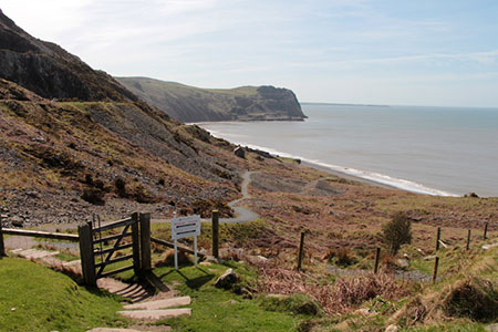
Turn right along the track and immediately fork left. Pass Cilia-uchaf on your right and another house on your left. Take the next footpath on the right through a metal kissing gate. You have now joined the Wales Coast Path which runs parallel to a wall on your left with views ahead along the coast. Continue through a gate and follow the path ahead. The path veers slightly left to a wall corner from where the path follows a fence on your right. Reaching a way marker post below a house, bear left downhill across the bracken covered hillside. The quarry wharf at Porth Howel can be seen down to your left.
A steady descent, with a few short stretches of ascent, provides a grandstand view the beach at Porth Y Nant. Nearing the sea, you pass the remains of the old incline that brought Granite down to ships. Today it is hard to imagine that this was once a busy area of quarrying. The path improves and you start to climb crossing several waste tips as you head uphill. You briefly join a concrete track before the path bears right up some steps to a gate. Pass through the grounds of Caffi Meinir (refreshments in season), pass the former quarrymens' cottages on the left and continue ahead to join the road.
The road climbs steeply up the valley of Nant Gwrtheryn with two hairpin bends to gain height. After the first hairpin you have a fine view to the old workings of Yr Eifl Quarry across the valley on your right. Reaching the second hairpin bend you have a fine view down to the sea from a viewpoint just off the right-hand side of the road. From here you have another 60 metres of ascent to reach the start in about half a kilometre!
Maps 

| Ordnance Survey Explorer 253 | Sheet Map | 1:25k | BUY |
| Anquet OS Explorer 253 | Digital Map | 1:25k | BUY |
| Ordnance Survey Digital Map Subscription | |||
| Latest Ordnance Survey Discounts | |||
Other walks nearby
| Walk 3378 | Gyrn Goch, Gyrn Ddu & Bwlch Mawr | mod/hard | 6.5 miles |
| Walk 3376 | Porth Dinllaen from Morfa Nefyn | easy | 4.5 miles |
| Walk 1762 | Pwllheli, Llanbedrog & Abersoch | easy/mod | 9.0 miles |
| Walk 3381 | Carn Fadryn Hillfort | easy | 1.5 miles |
| Walk 1796 | Garn Bach & Carn Fadryn | easy/mod | 5.0 miles |
| Walk 3382 | Llanbedrog Headland Circular | easy | 2.5 miles |
| Walk 3373 | Foryd Bay | easy | 5.6 miles |
| Walk 3370 | Criccieth & Llanstumdwy Circular | easy | 4.5 miles |
| Walk 3117 | Garnedd Goch via Cwm Silyn (Two Lakes Walk) | moderate | 6.0 miles |
| Walk 3371 | Mynydd Cilan from Hell's Mouth | moderate | 7.3 miles |
Recommended Books & eBooks
The Wales Coast Path
 A single guidebook to walking the whole Wales Coast Path - 1400km (870 miles) the length of Wales from Chester to Chepstow, including Anglesey, described in 57 stages. The route passes through the Snowdonia and Pembrokeshire National Parks and many AONBs and can be linked with the Offa's Dyke Path for a complete circuit of Wales.
More information
Snowdonia: 30 Low-level and easy walks - North
 Guidebook describing 30 walks in Snowdonia, Wales. Routes are mostly low level and on clear paths and showcase the region's beautiful scenery and rich history and culture. Part of a 2-volume set, this northern volume includes the Snowdon area, the Ogwen and Conwy Valleys, Betws-y-Coed, Beddgelert, Ffestiniog and the coast.
More information
