Llanbedrog Headland Circular
Llyn Peninsula Walk
Region - Llyn Peninsula
County/Area - Gwynedd - Llyn Peninsula
Author - Lou Johnson
Length - 2.5 miles / 4.1 km Ascent - 450 feet / 136 metres
Time - 1 hours 40 minutes Grade - easy
Walk Route Description
Click image to see photo description.
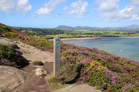
This easy Llŷn Peninsula walk starts from Llanbedrog and completes a circuit of the headland lying west of the village. The route follows a section of the Wales Coast Path around the high ground of Mynydd Tir-y-cwmwd with fine views south to Abersoch and east to Pwllheli.
The start is the main car park behind the beach in Llanbedrog (grid ref. SH330315). After parking return to the entrance and bear right passing St. Pedrog's church on your left. At the T-junction turn left and then left again in front of the church hall up Craig y Llan. Follow the lane soon passing a footpath on the left. Continue climbing ignoring another footpath on the left and one on the right. After a further 300 metres you reach a small parking area on the right.
Turn left up a lane (with a footpath sign and a no through road sign). Follow the lane uphill, past cottages and bear right at the junction. The tarmac ends and you continue ahead onto the headland. Follow the track past Mount Pleasant on your right after which the track narrows to a clear path. Shortly after you reach the Wales Coast Path (grid ref. SH327307) where you turn left.
The headland has several paths, but the advice is to follow the clear path closest to the clifftops which has white topped marker posts to aid navigation. Initially the path is someway from the cliff top but after passing through waist deep ferns you get a retrospective view west to Abersoch. Continuing along the main path the view to the east appears, which in clear weather includes the mountains of Snowdonia (Eryri). The path then continues into trees. Keep straight ahead on the paved and stepped path which leads back to the car park entrance used at the start of the walk.
Maps 

| Ordnance Survey Explorer 253 | Sheet Map | 1:25k | BUY |
| Anquet OS Explorer 253 | Digital Map | 1:25k | BUY |
| Ordnance Survey Digital Map Subscription | |||
| Latest Ordnance Survey Discounts | |||
Other walks nearby
| Walk 1762 | Pwllheli, Llanbedrog & Abersoch | easy/mod | 9.0 miles |
| Walk 3381 | Carn Fadryn Hillfort | easy | 1.5 miles |
| Walk 1796 | Garn Bach & Carn Fadryn | easy/mod | 5.0 miles |
| Walk 3371 | Mynydd Cilan from Hell's Mouth | moderate | 7.3 miles |
| Walk 3376 | Porth Dinllaen from Morfa Nefyn | easy | 4.5 miles |
| Walk 3375 | Mynydd Penarfynydd from Rhiw | easy | 3.3 miles |
| Walk 3044 | The Rivals (Yr Eifl) from Llithfaen | moderate | 4.5 miles |
| Walk 3374 | Porth y Nant & Nant Gwrtheryn Circular | easy/mod | 3.5 miles |
| Walk 3339 | Mynydd Anelog & the Whistling Sands | easy | 4.5 miles |
| Walk 3372 | Mynydd Mawr & Porth Meudwy Circular | moderate | 7.0 miles |
Recommended Books & eBooks
Snowdonia: 30 Low-level and easy walks - North
 Guidebook describing 30 walks in Snowdonia, Wales. Routes are mostly low level and on clear paths and showcase the region's beautiful scenery and rich history and culture. Part of a 2-volume set, this northern volume includes the Snowdon area, the Ogwen and Conwy Valleys, Betws-y-Coed, Beddgelert, Ffestiniog and the coast.
More information
Snowdonia: 30 Low-level and easy walks - South
 Guidebook describing 30 walks in Snowdonia, Wales. Routes are mostly low level and on clear paths and showcase the region's beautiful scenery and rich history and culture. Part of a 2-volume set, this southern volume includes Trawsfynydd, Bala, Dolgellau, Machynlleth, the Harlech Coast and the valleys of the Mawddach and Dyfi.
More information
