The Rivals (Yr Eifl) from Llithfaen
Llyn Peninsula Walk
Region - Llyn Peninsula
County/Area - Gwynedd - Llyn Peninsula
Author - Lou Johnson
Length - 4.5 miles / 7.3 km Ascent - 1535 feet / 465 metres
Time - 3 hours 50 minutes Grade - moderate
Walk Route Description
Click image to visit gallery of 6 images.
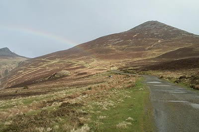
Rising to 564 metres above sea level the trio of hills known as the Rivals offer rugged walking and great views. Located on the Lleyn Peninsula in North Wales they are easily seen from Anglesey and the major mountains of northwestern Snowdonia (Eryri) perhaps offering an alternative if the high mountains are covered in cloud. Despite some scars left by quarrying activity the Rivals are full of interest especially with the partly restored Tre'r Ceiri Hill Fort atop one of the summits. Despite the short distance of the walk, remember there is considerable ascent to be done and the terrain is hard going in places with large rocks submerged in knee deep heather.
The start is the car park (grid ref. SH353440) reached by turning north in the village of Llithfaen on the B4417 Trefor to Nefyn road. From the parking two of the summits are visible but the third with its hill fort remains hidden until well into the walk. Leaving the car park head south east alongside the stone wall keeping it on your right. The path climbs gently before descending again into a broad valley.
Ahead lies the first objective, the attractive rocky outcrop of Caergribin (grid ref. SH367440) and for the most part the path is clear especially as far as the ladder stile. Reaching the rocky outcrop you are rewarded with some good views, especially to the south and west, and your first sight of the hill topped by the Tre'r Ceiri hill fort which will be visited next.
Descend from Caergribin on a clear path heading north-east. You soon join the main path as it heads for a ladder stile that takes you over a stone wall (grid ref. SH369443). From this point a well maintained path leads you up to the Hill Fort, which is superb with much restoration work and informative notice boards helping you to realise the scope of this massive fortification. It is also easy to understand the strategic nature of the location with first class views in all directions making it difficult for the enemy to launch a surprise attack.
After inspecting the fort return to the wall and cross the stile. Turn right and follow the path, which is feint in places, that climbs alongside the wall towards the summit of Yr Eifl. This is the highest of the three hills with a spectacular view down to the sea, nearly two thousand feet below you. The highest point is marked by a triangulation column. Descend southwest from the summit on a clear path that leads you back to the starting point.
Nigel Horrocks notes that "on a clear day, an alternative route to Yr Eifl, instead of returning to the ladder stile is: from the fort's main tourist entrance, walk the anti-clockwise path around the inside of the fort's walls until you reach the major breech on the western side of the wall which is another major entrance to the fort. When you walk through this entrance you will be looking directly at Yr Eifl, almost due west of where you are standing. Facing Yr Eifl, a few metres to your right, is a distinct path which traverses towards Yr Eifl and then becomes marked with discreet yellow paint marks on the rocks as the path weaves its way up through the rocks towards the summit. However this alternative could be a bit dodgy in mist or cloud."
Maps 

| Ordnance Survey Explorer 254 | Sheet Map | 1:25k | BUY |
| Anquet OS Explorer 254 | Digital Map | 1:25k | BUY |
| Ordnance Survey Digital Map Subscription | |||
| Latest Ordnance Survey Discounts | |||
Other walks nearby
| Walk 3378 | Gyrn Goch, Gyrn Ddu & Bwlch Mawr | mod/hard | 6.5 miles |
| Walk 3376 | Porth Dinllaen from Morfa Nefyn | easy | 4.5 miles |
| Walk 1762 | Pwllheli, Llanbedrog & Abersoch | easy/mod | 9.0 miles |
| Walk 3381 | Carn Fadryn Hillfort | easy | 1.5 miles |
| Walk 1796 | Garn Bach & Carn Fadryn | easy/mod | 5.0 miles |
| Walk 3382 | Llanbedrog Headland Circular | easy | 2.5 miles |
| Walk 3373 | Foryd Bay | easy | 5.6 miles |
| Walk 3370 | Criccieth & Llanstumdwy Circular | easy | 4.5 miles |
| Walk 3117 | Garnedd Goch via Cwm Silyn (Two Lakes Walk) | moderate | 6.0 miles |
| Walk 3371 | Mynydd Cilan from Hell's Mouth | moderate | 7.3 miles |
Recommended Books & eBooks
The Wales Coast Path
 A single guidebook to walking the whole Wales Coast Path - 1400km (870 miles) the length of Wales from Chester to Chepstow, including Anglesey, described in 57 stages. The route passes through the Snowdonia and Pembrokeshire National Parks and many AONBs and can be linked with the Offa's Dyke Path for a complete circuit of Wales.
More information
Snowdonia: 30 Low-level and easy walks - South
 Guidebook describing 30 walks in Snowdonia, Wales. Routes are mostly low level and on clear paths and showcase the region's beautiful scenery and rich history and culture. Part of a 2-volume set, this southern volume includes Trawsfynydd, Bala, Dolgellau, Machynlleth, the Harlech Coast and the valleys of the Mawddach and Dyfi.
More information
