Pwllheli, Llanbedrog & Abersoch
Llyn Peninsula Walk
Region - Llyn Peninsula
County/Area - Gwynedd
Author - Lou Johnson
Length - 9.0 miles / 14.6 km Ascent - 900 feet / 273 metres
Time - 5 hours 20 minutes Grade - easy/mod
Walk Route Description
Click image to see photo description.
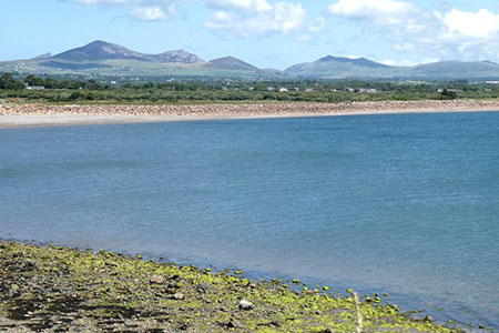
This linear walk between Pwllheli and Abersoch follows the Wales Coast Path through Llanbedrog. Highlights of the route include woodland near Llanbedrog and the superb panorama from Mynydd Tir-y-cwmwd which includes much of the Llyn Peninsula and the mountains of Snowdonia (Eryri). To return to start use bus route 18 between Abersoch and Pwllheli.
For simplicity, the start is Pwllheli railway station (grid ref. SH375350) with the bus station close by. Other parking options are nearby or by the seafront. With your back to the station, turn left and join Embankment Road (also the Wales Coast Path) which leads to the seafront. Turn right along the promenade and keeping to the left of a shelter join the red tarmac path behind the beach. Reaching the end of the promenade, keep ahead on a path between gorse buses. The path soon bends right to reach a tarmac drive. Turn left, soon passing a golf course on your right.
Beyond the golf course you pass a ruined farm and a bungalow to reach a gate. Bear left up to a metal kissing gate to follow the top of the embankment. At the next kissing gate, the path is enclosed with fences. Continue to cross a track (grid ref. SH341328). The onward path leads between fences around the rocky headland of Carreg y Defaid to reach a wooden kissing gate. Continue through a number of fields and gates initially with the fence to your left and then between fences. Bear left and descend to Llanbedrog beach. Continue past the beach huts to a stream where you turn right up a lane (Lon Nant-Iago).
Turn left towards Plas Glyn-yWeddw and continue past the large house on your right. Continue ahead at the mini-roundabout and bear right onto a rising tarmac path (Wales Coast Path fingerpost). Continue ahead onto a gravel path rising through trees. The path becomes paved and climbs quickly with flights of steps. Nearing the top there is an excellent view to the left down to Llanbedrog beach with the finest panorama from the 'Tin Man'. The path becomes rockier crossing moorland as you cross the flank of Mynydd Tir-y-cwmwd. The path loops around the hill for over a kilometre before descending steeply down to a lane and fingerpost (grid ref. SH324307).
Turn left and follow the tarmac lane. Take the left fork and continue down to Abersoch Beach. Continue for about two kilometres across the beach until just before you reach a rocky headland. Turn right on a path through trees which leads up to a road. Turn left into Abersoch which is worth exploring and also a source of refreshments. Return by bus to Pwllheli.
Maps 

| Ordnance Survey Explorer 253 | Sheet Map | 1:25k | BUY |
| Anquet OS Explorer 253 | Digital Map | 1:25k | BUY |
| Ordnance Survey Digital Map Subscription | |||
| Latest Ordnance Survey Discounts | |||
Other walks nearby
| Walk 3382 | Llanbedrog Headland Circular | easy | 2.5 miles |
| Walk 3381 | Carn Fadryn Hillfort | easy | 1.5 miles |
| Walk 1796 | Garn Bach & Carn Fadryn | easy/mod | 5.0 miles |
| Walk 3044 | The Rivals (Yr Eifl) from Llithfaen | moderate | 4.5 miles |
| Walk 3374 | Porth y Nant & Nant Gwrtheryn Circular | easy/mod | 3.5 miles |
| Walk 3376 | Porth Dinllaen from Morfa Nefyn | easy | 4.5 miles |
| Walk 3371 | Mynydd Cilan from Hell's Mouth | moderate | 7.3 miles |
| Walk 3370 | Criccieth & Llanstumdwy Circular | easy | 4.5 miles |
| Walk 3378 | Gyrn Goch, Gyrn Ddu & Bwlch Mawr | mod/hard | 6.5 miles |
| Walk 3375 | Mynydd Penarfynydd from Rhiw | easy | 3.3 miles |
Recommended Books & eBooks
Snowdonia: 30 Low-level and easy walks - South
 Guidebook describing 30 walks in Snowdonia, Wales. Routes are mostly low level and on clear paths and showcase the region's beautiful scenery and rich history and culture. Part of a 2-volume set, this southern volume includes Trawsfynydd, Bala, Dolgellau, Machynlleth, the Harlech Coast and the valleys of the Mawddach and Dyfi.
More information
Snowdonia: 30 Low-level and easy walks - North
 Guidebook describing 30 walks in Snowdonia, Wales. Routes are mostly low level and on clear paths and showcase the region's beautiful scenery and rich history and culture. Part of a 2-volume set, this northern volume includes the Snowdon area, the Ogwen and Conwy Valleys, Betws-y-Coed, Beddgelert, Ffestiniog and the coast.
More information
