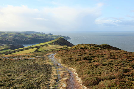
Great Hangman Hill from Combe Martin
Exmoor Walk
Nat Park - Exmoor
County/Area - Devon
Author - Lou Johnson
Length - 4.3 miles / 7 km Ascent - 1250 feet / 379 metres
Time - 3 hours 20 minutes Grade - easy/mod
Walk Route Description

Click image to see photo description.
This North Devon walk starts from Combe Martin and explores a section of scenic coast lying within the boundaries of the Exmoor National Park. The route uses inland tracks and paths to reach the summit of Great Hangman Hill from where there are extensive views along this fine section of coast. The walk then follows the South West Coast Path including a short diversion to the summit of Little Hangman Hill before descending back to the start.
The start is the Kiln pay and display car park on the north side of the A399 at the rear of the beach (grid ref. SS578473). After parking return to the A399 and turn left and follow the pavement on your left. Continue past a row of shops on your left and a side road named Hangman Path also on your left. Continue along the pavement to turn left up a signed public footpath just before a parking pay machine. This path bears to the right and leads to a West Challacombe Lane where you cross the road and follow the signed path on the opposite side of the road (grid ref. SS581471).
Follow the path ahead which soon becomes a track (Rock Lane) which leads to Shute Lane. Again, continue straight ahead uphill for 600 metres ignoring paths to the right and left. Where the lane bends to the right, fork left onto a track (signed as a footpath). This leads over Knap Down to reach a T-junction of tracks (grid ref. SS598471). Turn left and continue past Girt Down Farm on your left. Just beyond the farm follow the enclosed track as it bends to the left. Continue ahead into a field keeping to the right-hand edge. Continue through a gate and follow the clear path ahead to reach a path junction after 250 metres (grid ref. SS604478). Turn left here onto the South West Coast Path climbing steadily onto the summit of Great Hangman Hill, which rises to just over 1000 feet above the sea.
After enjoying the extensive view along the coast, start the descent down the South West Coast Path which is clear and easy to follow. Ahead the conical shape of Little Hangman Hill is the next objective. A short ascent to the summit is worth the extra effort before continuing down the South West Coast Path towards Combe Martin. There are several paths, but it is easier to stay on the coast path which continues along Lester Cliff. As you reach the end of Lester Cliff continue straight ahead where the coast path turns sharp left. This path leads over grass back to the car park used at the start of the walk.
Maps 

| Ordnance Survey Explorer OL9 | Sheet Map | 1:25k | BUY |
| Anquet OS Explorer OL9 | Digital Map | 1:25k | BUY |
| Ordnance Survey Digital Map Subscription | |||
| Latest Ordnance Survey Discounts | |||
Other walks nearby
| Walk 3394 | Holdstone Down & Trentishoe | moderate | 7.0 miles |
| Walk 3390 | Heddon Valley from Woody Bay | moderate | 5.3 miles |
| Walk 1797 | Morthoe, Morte Point & Bull Point circular | easy/mod | 6.0 miles |
| Walk 3391 | Valley of Rocks frrom Lynton | easy/mod | 3.8 miles |
| Walk 1910 | Countisbury and Watersmeet from Lynmouth | easy/mod | 4.5 miles |
| Walk 2028 | Croyde to Baggy Point Circular | easy | 5.5 miles |
| Walk 1727 | Shallowford, Hoar Oak Tree & The Chains | moderate | 11.7 miles |
| Walk 2387 | Pinkery Pond Circular | easy/mod | 5.8 miles |
| Walk 3729 | Foreland Point | moderate | 5.0 miles |
| Walk 3749 | Codden Hill Circular | easy/mod | 4.8 miles |
Recommended Books & eBooks
South West Coast Path Map Booklet - Minehead to St Ives
 Map of the northern section of the 630 mile (1014km) South West Coast Path National Trail. Covers the trail from Minehead to St Ives along the north Devon and Cornish coastline. This convenient and compact booklet of Ordnance Survey 1:25,000 maps shows the route, providing all of the mapping you need to walk the trail in either direction.
More information
The South West Coast Path
 Guidebook to walking the entire South West Coast Path National Trail. The route runs for 630 miles from Minehead to Poole along the north Devon, Cornish, south Devon and Dorset coastline. Divided into 45 stages, this long-distance coastal trek could be completed within 4 weeks, or walked in sections. Guide includes maps and essential information.
More information

