An introduction to the Breamish Valley
Northumberland Walk
Nat Park - Northumberland
County/Area - Northumberland County
Author - Lou Johnson
Length - 2.0 miles / 3.3 km Ascent - 495 feet / 150 metres
Time - 1 hours 30 minutes Grade - easy
Walk Route Description
Click image to see photo description.
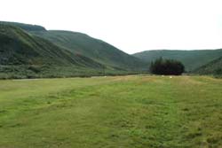
This very short walk is included to encourage you to explore the Northumberland National Park. It is an ideal brief excursion for those heading north or south along the A697 from Newcastle to Coldstream.
To reach the start leave the A697 on the road signed Ingram. Continue past the entrance to the National Park Visitor Centre and continue through the village. After about a mile there is a parking area with toilets on your right (grid ref. NU007163).
After parking cross the road and follow the track and path to the summit of Brough Law. The summit, a site of an ancient fort, is soon reached and provides excellent views in all directions. Of particular note is the view north-west to the Cheviot (the highest mountain in the area) although the valley and its immediate surroundings offer much of visual interest.
All that remains is to retrace your steps to the parking area although a competent walker equipped with an appropriate map will be able to extend the walk to suite their needs.
Maps 

| Ordnance Survey Explorer OL16 | Sheet Map | 1:25k | BUY |
| Anquet OS Explorer OL16 | Digital Map | 1:25k | BUY |
| Ordnance Survey Digital Map Subscription | |||
| Latest Ordnance Survey Discounts | |||
Other walks nearby
| Walk 1766 | Cushat Law and Bloodybush Edge from Hartside | mod/hard | 12.5 miles |
| Walk 1764 | The Cheviot from Langleeford | mod/hard | 8.2 miles |
| Walk 1765 | Comb Fell & Hedgehope Hill from Langleeford | mod/hard | 8.9 miles |
| Walk 1776 | The Cheviot & Auchope Cairn from Langleeford | mod/hard | 10.0 miles |
| Walk 2152 | Hartshope Linn (waterfall) from Langleeford | easy | 4.4 miles |
| Walk 2153 | Housey Crags from Langleeford | easy/mod | 2.0 miles |
| Walk 2282 | Bewick Moor | moderate | 9.1 miles |
| Walk 3085 | The Dodd & Wether Cairn | moderate | 9.5 miles |
| Walk 2299 | The Cheviot | moderate | 9.0 miles |
| Walk 1200 | Windy Gyle | moderate | 7.5 miles |
Recommended Books & eBooks
Walking in Northumberland
 This guidebook contains detailed route descriptions for 36 day walks in Northumberland including the Cheviot Hills. The terrain varies from wild walks and craggy ascents to gentle riverside strolls. Each route ranges from 4 to 16 miles in length and there is the opportunity to link several walks together to create longer treks.
More information
Hadrian's Wall Path
 Hadrians Wall Path guidebook to walk the 84 mile National Trail. Described in both directions, the main description is west to east between Bowness-on-Solway and Wallsend, Newcastle, with extensions to Maryport and South Shields. With extensive historical information related to this World Heritage site and separate 1:25,000 OS map booklet included.
More information
