Haywood Slade & Sherbrook from Seven Springs
Cannock Chase Walk
Region - Cannock Chase
County/Area - Staffordshire - Cannock Chase
Author - Lou Johnson
Length - 4.0 miles / 6.5 km Ascent - 500 feet / 152 metres
Time - 2 hours 30 minutes Grade - easy
Walk Route Description
Click image to visit gallery of 3 images.
This short Cannock Chase walk starts from the Seven Springs parking area (grid ref. SK004205), which is reached from the A513 Stafford to Rugeley main road at Weetman's Bridge where a gravel track leads south towards this popular 'beauty spot'. On busy days parking may be at a premium and parking in lay-by adjacent to Weetman's Bridge may be necessary. Once away from the parking area the crowds are left behind, and you can enjoy a peaceful walk.
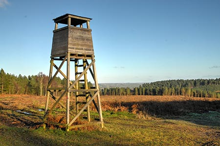
After parking walk to the southern end of the parking area (the opposite end to the access track) and take the footpath on the right passing around a wooden barrier onto a clear path. After a short way the path forks (grid ref. SK003203). Keep straight head here and follow a wide gravel track uphill onto Heywood Warren and a junction of tracks by a wooden fire tower (grid ref. SK998197). Go half right here following a continuation of the track used for first section of the walk.
You are walking in a generally southerly direction on a clear track. There are many side paths and tracks which should be ignored. After just over a kilometre you reach an earth embankment on the right (grid ref. SJ996186). During the First World War this was constructed as a rifle range when the area was used for training troops. It lasted until the early 1960's when it fell out of use. Continue past the old range to the next junction (grid ref. SJ996185). Turn right and walk parallel with the range to the next junction (grid ref. SJ993184). Turn right and walk past the range which is on your right bearing right at the junction adjacent to the end of the range.
You are now heading northwards. Stay ahead at all junctions following a clear gravel track and continue down Haywood Slade. After walking for just over a kilometre from the range the track reaches the floor of the Sherbrook Valley. Continue ahead on the track to reach the stepping stones where picnic tables area available (grid ref. SJ987200). Do not cross the Sher Brook. Turn right onto a clear path with a fence on your immediate left. This leads back through pleasant surroundings, typical of Cannock Chase, to the start after 1.5 kilometres.
Maps 

| Ordnance Survey Explorer 244 | Sheet Map | 1:25k | BUY |
| Anquet OS Explorer 244 | Digital Map | 1:25k | BUY |
| Ordnance Survey Digital Map Subscription | |||
| Latest Ordnance Survey Discounts | |||
Other walks nearby
| Walk 1370 | Sherbrook Valley from Punch Bowl, Milford | easy | 4.0 miles |
| Walk 2023 | Cannock Chase War Trail | moderate | 7.5 miles |
| Walk 1189 | Cannock Chase Circular | easy | 6.5 miles |
| Walk 2911 | Seven Springs, Little Haywood, Shugborough & Milford | easy | 6.5 miles |
| Walk 2111 | Milford, Seven Springs, Little Haywood & Shugborough | easy | 6.0 miles |
| Walk 1802 | Shugborough Park from Milford | easy | 4.5 miles |
| Walk 1324 | Glacial Boulder & Sherbrook | easy | 3.5 miles |
| Walk 1413 | Sherbrook, Stepping Stones & Freda's Memorial | easy | 6.0 miles |
| Walk 1348 | Sherbrook Valley & Katyn Memorial | easy | 4.0 miles |
| Walk 2199 | Brocton & Walton-on-the-Hill Circular | easy | 3.5 miles |
Recommended Books & eBooks
Walking in the Peak District - White Peak East
 Guidebook describing 42 half-day and day walks in the limestone landscapes of Derbyshire's White Peak, part of the Peak District National Park. One of two volumes, this book covers the east of the region, with potential bases including Bakewell, Eyam, Castleton, Birchover, Matlock and Wirksworth.
More information
