Brocton & Walton-on-the-Hill Circular
Staffordshire Walk
County/Area - Staffordshire - Mid Staffordshire
Author - Lou Johnson
Length - 3.5 miles / 5.7 km Ascent - 240 feet / 73 metres
Time - 2 hours 0 minutes Grade - easy
Walk Route Description
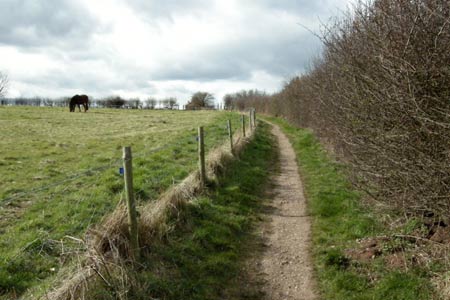
Click image to visit gallery of 6 images.
This walk explores a section of Staffordshire countryside between the eastern outskirts of Stafford and Cannock Chase Area of Outstanding Natural Beauty. The route is over good paths with views to Cannock Chase and the opportunity to explore the villages of Walton-on-the-Hill and Brocton.
Parking is available along the verge on Oldcroft Road (grid ref. SJ9522204) adjacent to the signed bridleway to Brocton. The start is reached by leaving the A34 Stafford to Cannock road just outside of the Stafford town boundary at the junction (ref. SJ950201) signed Walton-on-the-Hill.
After parking take the signed path towards Brocton. This path initially descends between fields to bring you out at a road (grid ref. SJ963194). Turn left here and follow the road. You need to follow the main road and this bear right at the first junction and then veers left beside Brocton village green.
Continue along this road in the direction of Milford. As the road begins to climb the first obvious hill (by the end of the 30 mph zone) go left to locate the footpath (grid ref. SJ972199) to Walton-on-the-Hill. This path is located just before a small estate of fairly modern large houses on the left hand side of the road. Once located, the onward route is clear and you are soon in open country with views ahead to the village of Walton-on-the-Hill with the church steeple an obvious landmark.
The path descends into a broad valley and follows a slightly amended route to that shown on OS maps. However continue ahead always aiming for the church spire. Just before the final climb up to Walton you arrive at Jacob's Ladder (grid ref. SJ963207). Today this is a set of wooden steps with an information board providing historical background to this well-known local feature.
After Jacob's Ladder the path climbs gently to join a roughly surfaced lane. Continue along this to meet a lane. Bear right and walk to the T-junction. Go left and walk up past the church to another T-junction. Opposite is the former blacksmiths workshop. Turn right and continue to next major junction with a give way sign. Turn left into Oldcroft Road and return to the start.
Maps 

| Ordnance Survey Explorer 244 | Sheet Map | 1:25k | BUY |
| Anquet OS Explorer 244 | Digital Map | 1:25k | BUY |
| Ordnance Survey Digital Map Subscription | |||
| Latest Ordnance Survey Discounts | |||
Other walks nearby
| Walk 1394 | Bednall & Acton Trussell from near Stafford | easy | 6.5 miles |
| Walk 1189 | Cannock Chase Circular | easy | 6.5 miles |
| Walk 2911 | Seven Springs, Little Haywood, Shugborough & Milford | easy | 6.5 miles |
| Walk 2111 | Milford, Seven Springs, Little Haywood & Shugborough | easy | 6.0 miles |
| Walk 1802 | Shugborough Park from Milford | easy | 4.5 miles |
| Walk 2443 | Tixall from St Thomas Priory near Stafford | easy | 7.0 miles |
| Walk 2023 | Cannock Chase War Trail | moderate | 7.5 miles |
| Walk 1370 | Sherbrook Valley from Punch Bowl, Milford | easy | 4.0 miles |
| Walk 1324 | Glacial Boulder & Sherbrook | easy | 3.5 miles |
| Walk 1413 | Sherbrook, Stepping Stones & Freda's Memorial | easy | 6.0 miles |
Recommended Books & eBooks
Walking in the Peak District - White Peak East
 Guidebook describing 42 half-day and day walks in the limestone landscapes of Derbyshire's White Peak, part of the Peak District National Park. One of two volumes, this book covers the east of the region, with potential bases including Bakewell, Eyam, Castleton, Birchover, Matlock and Wirksworth.
More information
