Cissbury Ring and Chanctonbury Ring from Steyning
South Downs Walk
Nat Park - South Downs
County/Area - West Sussex
Author - Hugh Maguire
Length - 10.5 miles / 17.1 km Ascent - 1520 feet / 461 metres
Time - 6 hours 50 minutes Grade - moderate
Maps 

| Ordnance Survey Explorer OL10 | Sheet Map | 1:25k | BUY |
| Anquet OS Explorer OL10 | Digital Map | 1:25k | BUY |
| Ordnance Survey Landranger 198 | Sheet Map | 1:50k | BUY |
| Anquet OS Landranger 198 | Digital Map | 1:50k | BUY |
Walk Route Description
Click image to visit gallery of 6 images.
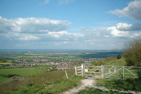
This West Sussex walk in the South Downs National Park explores some interesting country north of Steyning and includes the Iron Age Forts of Cissbury Ring and Chanctonbury Ring. The village of Steyning is approached using the A283 and is a beautiful Sussex village nestling under the South Downs. To park your car at the start of this walk you need to find a cul-de-sac at grid ref TQ170106. After parking, turn left out of the cul-de-sac, follow the road for a bit before taking the steep path south west straight up Steyning Round Hill. About halfway up is a gate and you keep on the path until you reach a bench where you turn left.
At the junction of paths (grid ref. TQ163100), where there is a sort of memorial, go west to No Man's Land and another junction of paths (Grid ref. TQ151097). From here go south down a beautiful valley until you reach a large track where you head west to the car park at the foot of Cissbury Ring (Grid ref TQ140085). From here it is an easy climb onto the ring, a circuit of which will offer a variety of views of the surrounding area.
Descend back to the car park and turn north. Follow a fairly wide track until you reach the South Downs Way (Grid ref TQ145114). From here an out and back walk to Chanctonbury Ring can be completed by turning left. Chanctonbury Ring is a small Iron Age hillfort that was use in various periods of history and is still a notable Sussex landmark. Located on a prominence on the northern edge of the South Downs, it overlooks a large portion of the Weald below with the old ridgeway across the downs passing just to the south.
After visiting Chanctonbury Ring, return east along the South Downs Way until you come to the junction of paths by the memorial (grid ref. TQ163100). Turn north here and make your way back via the bench and the car park to your car.
Other walks nearby
| Walk 1888 | Cissbury Ring, Chanctonbury Ring & Coombes | moderate | 12.5 miles |
| Walk 2109 | Upper Beeding to Washington by the South Downs Way | easy/mod | 7.0 miles |
| Walk 3078 | Cissbury Ring & Chanctonbury Ring from Washington | easy/mod | 8.3 miles |
| Walk 3310 | Washington to Littleton Farm by the South Downs Way | moderate | 13.0 miles |
| Walk 1983 | Edburton Hill from Fulking | easy/mod | 6.1 miles |
| Walk 3488 | Devil's Dyke Circular | easy | 2.5 miles |
| Walk 3487 | Edburton Hill & Devil's Dyke from Saddlescombe | hard | 10.5 miles |
| Walk 1667 | Blackpatch Hill & Harrow Hill from near Storrington | easy/mod | 7.2 miles |
| Walk 3464 | Rackham Hill & Kithurst Hill Circular | easy/mod | 6.7 miles |
| Walk 3213 | Pyecombe, Devil's Dyke & Upper Beeding | easy/mod | 8.0 miles |
Recommended Books & eBooks
Walks in the South Downs National Park
 Guidebook with 40 circular walks throughout the South Downs National Park, exploring the beautiful chalk hills between Eastbourne and Winchester. The walks range from under 5 miles to 11 miles, including Beachy Head and the Seven Sisters, Ditchling Beacon and hundreds of prehistoric sites. Accessible all year, but wild flowers best in spring.
More information
The South Downs Way
 Guidebook to walking the South Downs Way National Trail, a 100 mile (160km) route between Winchester and Eastbourne through the South Downs National Park, described in both directions over 12 stages. Easy walking on ancient and historical tracks, taking in wooded areas, delightful river valleys and pretty villages. With 1:25K OS map booklet.
More information
Messaging & Social Media
Message Walking Britain and follow the latest news.

Mountain Weather
Stay safe on the mountains with detailed weather forecasts - for iOS devices or for Android devices.