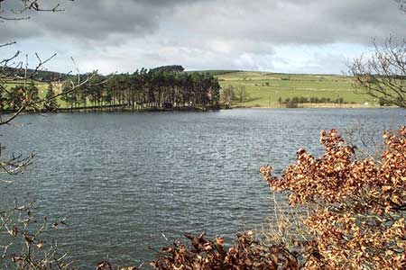
Tunstall Reservoir from Wolsingham
Durham Walk
County/Area - Durham
Author - Lou Johnson
Length - 7.3 miles / 11.9 km Ascent - 800 feet / 242 metres
Time - 4 hours 30 minutes Grade - easy/mod
Maps 

| Ordnance Survey Explorer OL31 | Sheet Map | 1:25k | BUY |
| Anquet OS Explorer OL31 | Digital Map | 1:25k | BUY |
| Ordnance Survey Explorer 302 | Sheet Map | 1:25k | BUY |
| Anquet OS Explorer 302 | Digital Map | 1:25k | BUY |
Walk Route Description
Click image to see photo description.
This walk from the market town of Wolsingham in Weardale (County Durham) explores the area to the north of the town. The route takes you into a beautiful valley surrounded by wild moorland with Tunstall Reservoir, the main objective of the walk, partially surrounded by woodland. The route follows good paths and tracks.
From the town centre take the B6296 north (opposite the Black Bull). After 250 metres turn left (signed Demesne Mill Picnic Area). Continue to the parking area (grid ref. NZ075375) overlooking the Waskerley Beck. Walk through the gate at the northern end of the parking area and follow the path with the beck on your right. Continue beside the beck for 200 metres and follow the path as it turns left. Continue across a field to a date. Turn right, cross footbridge and continue to next gate. Turn left and walk along the field with the hedge on your left and exit onto a road (grid ref. NZ067383).
Cross the road and take the path on the right off the farm access drive. This path then follows the left-hand edge of fields for a kilometre to reach a plantation on your left. Continue ahead past the plantation to reach a solitary tree at a wall junction (grid ref. NZ057394). Cross the small field to a ladder stile and continue along the path beside a wood on your left. Follow the path as it bends left. Continue to a wall and turn right keeping the wall on your immediate left to reach a track. Turn left along the track to reach High Jofless Farm.
Follow the waymarked path through the farm to join the farm's access drive. Follow the drive with the wood on your left. At the end of the wood turn left onto a waymarked path with the wood on your left. Pass through a gate and then walk half-right to a wall stile. Follow the path across the next field to the far right-hand corner. To join a waymarked path that heads right across a field to reach a road (grid ref. NZ063407).
Turn left and pass Tunstall Reservoir dam on your right. You have choice of following the road or the waterside path which is reached through a gate on the right. 600 metres from the dam you reach a picnic area where the waterside path returns to the road. Continue along the road, cross a bridge, and turn right over a stile to regain the waterside path to reach a track just beyond the end of the reservoir (grid ref. NZ068418). Turn right across the bridge and then right again onto the path along the eastern shores of the reservoir.
At the southern end of the reservoir the path leads onto a road. Turn left and follow the road around to Backstone Bank Farm. At the end of the farm buildings turn right over a bridge onto a grassy path and continue south with a wall on your left. The view of the valley on this section is glorious. Continue ahead keeping the fence on your immediate right. Cross Spring Gill and stay at the same level across three fields to reach the corner of Baal Hill Wood (grid ref. NZ072390).
Approaching Baal Hill House Farm, keep to the left of the buildings to reach a track (grid ref. NZ075386). Leave the main track and walk half-left across a field along a grassy track. Keep to the left of several fields passing through kissing gates as you make progress to reach a road. Turn right and then take the first footpath on the left with fingerpost and a short flight of steps. Follow the well-trodden path across two fields to reach the B6296. Turn right, cross the bridge and then right again back to the car park.
Other walks nearby
| Walk 1955 | Sunnyside Edge from Wolsingham | easy/mod | 7.5 miles |
| Walk 2382 | Smiddy Shaw Reservoir Circular | easy/mod | 6.2 miles |
| Walk 3634 | Catterick Moss & Bollihope Carrs | moderate | 5.6 miles |
| Walk 2089 | College Edge & Cuthbert's Currick from Edmundbyers | easy/mod | 8.0 miles |
| Walk 2393 | Weardale Circular from Westgate | easy/mod | 6.4 miles |
| Walk 3315 | Warlaw Pike & Birkside Fell from Blanchland | moderate | 8.0 miles |
| Walk 3722 | Buckshott Fell & Sikehead Mines | easy/mod | 6.5 miles |
| Walk 2815 | Pennypie and Blanchland from Baybridge | easy/mod | 3.8 miles |
| Walk 2157 | Romaldkirk & Cotherstone | easy | 5.0 miles |
| Walk 2170 | Eggleston & Mickleton from Romaldkirk | easy/mod | 5.8 miles |
Recommended Books & eBooks
Walking in County Durham
 Guidebook offering detailed descriptions of 40 day walks, plus 10 traffic-free cycle routes along old railway trackbeds. Together they cover 450 miles and spread all over County Durham to show the region's history and natural wonders. The terrain covered ranges from field paths to open moorlands, from the North Sea to the high Pennines.
More information
Messaging & Social Media
Message Walking Britain and follow the latest news.

Mountain Weather
Stay safe on the mountains with detailed weather forecasts - for iOS devices or for Android devices.