Woodford & Hollygrove Wood from Duckpool
Cornwall Walk
County/Area - Cornwall
Author - Lou Johnson
Length - 5.1 miles / 8.3 km Ascent - 900 feet / 273 metres
Time - 3 hours 30 minutes Grade - easy/mod
Walk Route Description
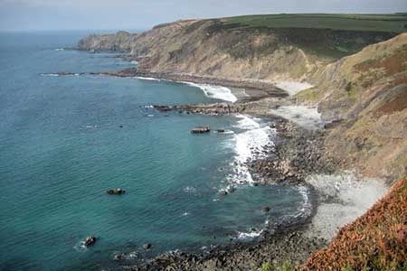
Click image to see photo description.
This North Cornwall walk combines a rugged stretch of coast with rolling farmland and woodland. The route follows the undulating South West Coast path from Duckpool to Stanbury Mouth. Turning inland the walk climbs across fields to the village of Woodford. Turning south the walk descends steeply into a valley to pass through pleasant Hollygrove Wood.
The walk starts from the small car park at Duckpool (grid ref. SS202117) adjacent to public toilets. After parking walk to towards the seas and turn right onto the South West Coast Path. The path climbs over Steeple Point and then undulates for a while before climbing above Harscott High Cliff. A steep descent takes you down to a footbridge at Stanbury Mouth (grid ref. SS201135). Cross the footbridge and turn inland.
The route initially follows a grassy track up a deep valley. After 500 metres the track turns sharp left. Continue ahead on a path (following yellow waymarks) across fields to a lane at Eastway Manor (grid ref. SS212137). Cross the lane ands take the track opposite. Continue along the waymarked path ignoring a footpath on the right as you approach Woodford. Continue ahead onto Woodville Road. Turn right uphill and continue to a T-junction. Turn right along the no-through road to pass Shear's Farm on your right. Follow the lane as it bends left and continue up to a fork with farm buildings ahead. Fork right onto a gravel track.
The track is initially enclosed by hedges but soon leads into a field. The path then keeps to the right-hand hedge and continues to a gate (grid tref. SS217129). Pas through the gate and turn left along a track. The track soon forks. Fork right (yellow waymarks) and descend into the wood. After 200 metres take the path on the right and continue to the bottom of the valley (grid ref. SS216128). Turn left across a stream, cross a stile, and turn right along a track. Continue down the valley for a kilometre to a lane. Bear right along the lane, cross a ford and bear left up to a lane. Bear left to a fork and keep right (signed Duckpool) and return to the start.
Maps 

| Ordnance Survey Explorer 126 | Sheet Map | 1:25k | BUY |
| Anquet OS Explorer 126 | Digital Map | 1:25k | BUY |
| Ordnance Survey Digital Map Subscription | |||
| Latest Ordnance Survey Discounts | |||
Other walks nearby
| Walk 3207 | Knap Head to Mansley Cliff | moderate | 8.0 miles |
| Walk 1788 | Welcombe Mouth and Darracott | moderate | 6.0 miles |
| Walk 3208 | Stoke & Hartland Quay | moderate | 6.4 miles |
| Walk 3755 | Dizzard Point, Millook from Penhalt Cliff | moderate | 6.0 miles |
| Walk 1076 | Dizzard Point & Crackington Haven | moderate | 8.0 miles |
| Walk 1261 | Hartland Point circular | moderate | 10.0 miles |
| Walk 1824 | Hartland Point Circular | easy | 3.0 miles |
| Walk 2730 | St Gennys & Castle Point from Crackington Haven | easy/mod | 3.0 miles |
| Walk 2731 | Cambeak & Crackington Haven | easy/mod | 4.3 miles |
| Walk 1719 | Clovelly & the South West Coast Path | easy/mod | 6.0 miles |
Recommended Books & eBooks
South West Coast Path Map Booklet - Minehead to St Ives
 Map of the northern section of the 630 mile (1014km) South West Coast Path National Trail. Covers the trail from Minehead to St Ives along the north Devon and Cornish coastline. This convenient and compact booklet of Ordnance Survey 1:25,000 maps shows the route, providing all of the mapping you need to walk the trail in either direction.
More information
Walking in Cornwall
 This guidebook includes routes to 40 day walks in Cornwall. From short, easy strolls to longer, wilder routes, there is plenty to appeal to both families and experienced walkers. The walks explore the interior and coasts, including walks through picturesque villages, old tin-mining areas and the Lizard and Land's End Peninsulas.
More information
