Cambeak & Crackington Haven
Cornwall Walk
County/Area - Cornwall
Author - Lou Johnson
Length - 4.3 miles / 7 km Ascent - 1000 feet / 303 metres
Time - 3 hours 10 minutes Grade - easy/mod
Walk Route Description
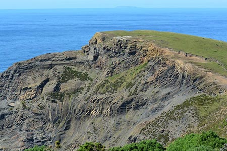
Click image to see photo description.
The Cornish village of Crackington Haven nestles in a dramatic section of coast with high cliffs. This energetic walk heads south from the village exploring the coast and the headland of Cambeak before returning to the start by following inland paths through a wooded valley. Crackington Haven has a pay and display car park (grid ref. SX143968), which can be busy in high season.
After parking walk towards the sea and turn left onto the signed South West Coast Path. This path climbs steeply with your effort soon rewarded by some good views along the coast in either direction. Like most sections of coastal path, the way ahead is undulating with regular descents and ascents. However, you soon reach the headland of Cambeak where the views extend in both directions along this rugged coast with its contorted rock strata.
Continue south along the coast path. You will soon reach a sign post to Trevigue 200m. From here continue along the coast path for another 300 metres to take the next footpath on the left (grid ref SX132949). This leads half left up a field to reach a lane. Cross the road to a stile and followed the waymarked path across a field to a gap in the trees. Cross the footbridge and continue uphill to Pengold. The path around the farm is indicated yellow arrows around the buildings.
Go through the gate and keep a hedge to your right. Go over the stile and continue down through trees to a stream. Go over the stile to reach a path junction where you head left signed to 'Haven'. The path parallels the stream and crosses it on a footbridge. Follow the signs and then go left to parallel the stream which is now on your left. Continue to reach a lane. Turn left along the lane to return to the start.
If you have the time and energy, you can continue to Walk 2730 and explore the coastal scenery to the north of Crackington Haven.
Maps 

| Ordnance Survey Explorer 111 | Sheet Map | 1:25k | BUY |
| Anquet OS Explorer 111 | Digital Map | 1:25k | BUY |
| Ordnance Survey Digital Map Subscription | |||
| Latest Ordnance Survey Discounts | |||
Other walks nearby
| Walk 1076 | Dizzard Point & Crackington Haven | moderate | 8.0 miles |
| Walk 3755 | Dizzard Point, Millook from Penhalt Cliff | moderate | 6.0 miles |
| Walk 1029 | Tintagel to Boscastle | moderate | 9.0 miles |
| Walk 1808 | Brown Willy, exploring Cornwall's highest Tors | easy/mod | 4.0 miles |
| Walk 3279 | Tors of Bodmin Moor | moderate | 10.0 miles |
| Walk 1996 | Woodford & Hollygrove Wood | easy/mod | 5.1 miles |
| Walk 1883 | Advent Church | easy | 5.2 miles |
| Walk 3207 | Knap Head to Mansley Cliff | moderate | 8.0 miles |
| Walk 1788 | Welcombe Mouth and Darracott | moderate | 6.0 miles |
| Walk 3264 | Port Quin & Port Isaac Circular | easy/mod | 5.7 miles |
Recommended Books & eBooks
South West Coast Path Map Booklet - St Ives to Plymouth
 Map of part of the southern section of the 630 mile (1014km) South West Coast Path National Trail. Covers the trail from St Ives to Plymouth along the west Cornwall and Devon coastline. This convenient and compact booklet of Ordnance Survey 1:25,000 maps shows the route, providing all of the mapping you need to walk the trail in either direction.
More information
Walking in Cornwall
 This guidebook includes routes to 40 day walks in Cornwall. From short, easy strolls to longer, wilder routes, there is plenty to appeal to both families and experienced walkers. The walks explore the interior and coasts, including walks through picturesque villages, old tin-mining areas and the Lizard and Land's End Peninsulas.
More information
