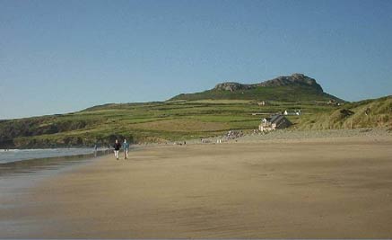
St. David's Head & Carn Llidi
Pembrokeshire Coast Walk
Nat Park - Pembrokeshire Coast
County/Area - Pembrokeshire
Author - Jacinta Ashworth
Length - 4.5 miles / 7.3 km Ascent - 300 feet / 91 metres
Time - 2 hours 30 minutes Grade - easy/mod
Maps 

| Ordnance Survey Explorer OL35 | Sheet Map | 1:25k | BUY |
| Anquet OS Explorer OL35 | Digital Map | 1:25k | BUY |
| Ordnance Survey Landranger 157 | Sheet Map | 1:50k | BUY |
| Anquet OS Landranger 157 | Digital Map | 1:50k | BUY |
Walk Route Description
Click image to visit gallery of 2 images.
An impressively rugged coastal walk with perhaps the finest seaboard hill in Pembrokeshire, Carn Llidi (595 ft ; 181m), for the climax. Starting from the glorious sweep of Whitesands Bay, the walk goes around the rocky and rugged headland, then turns inland over the shoulder and around the base of Carn Llidi, with an option of climbing to the summit for the magnificent view. Although the coastal part of the route is rockier than most, there are no particularly strenuous sections.
Whitesands Bay , a curving, mile long expanse of flat sands, is one of the finest beaches in the country and one of Pembrokeshire's most popular swimming and surfing places. At very low tide the remains of a forest are revealed, consisting of stumps of birch, fir, hazel and oak trees.
The start is the car park at Whitesands Bay (Grid ref. SM734272). Facing the beach, take the signposted coast path to the right of a telephone box. Proceed between fences; after 150yds fork right (left goes to Trwynhwrddyn promontory). This promontory is the site of St. Patrick's Chapel (no ruin survives), built between the 6 th and 10 th centuries on the site where St. Patrick is believed to have originally embarked for Ireland. Here sea voyagers used to pray for a safe journey and offer thanks for their arrival.
Continue heading steadily uphill, following the coast path along the top of rugged cliffs, past a National Trust sign and over a footbridge (left is an optional detour to the sandy beach of Porthmelgan). Continue along to end of St. David's Head, or Penmaen Dewi (Grid ref. SM 724279). Described in a Roman survey of the known world in AD140 as the 'Promontory of the Eight Perils', this low but rugged headland looks west towards the Bishop's and Clerk's Rocks. From this wild and windswept peninsula the all round views are superb: to the left across Whitesands Bay to Ramsey Sound and Ramsey Island, ahead along the lovely bays of Porth Lleuog and Porthmelgan towards the end of the promontory, and to the right to the distinctive profile of Carn Llidi.
At the end of the headland the path turns right to continue in a north easterly direction, and about 50 yds to the right of it is the 5,000 year old burial chamber of Coetan Arthur, with an 8ft capstone and supports; it is difficult to spot amid the rocky terrain but lies immediately below the wall of crags ahead.
Inland to your right is the big hill of Carn Llidi. Continue along the coast path, between rocks and heather. Soon views open up along the North coast of Pembrokeshire. When you have almost passed Carn Llidi, look out for a rectangular walled enclosure on the right, below the left shoulder of Carn Llidi. Head right (Grid ref. SM 735288), leaving the coast path, along a grassy track that heads up to the enclosure and continue passing to the right of it heading uphill. At the top of the shoulder, where the view ahead opens, a wall joins on the left.
Optional summit climb: The sure-footed now have the option of turning right up to the rocky summit of Carn Llidi, although the path is not defined near the top and care is needed From the summit trig point (Grid ref. SM 738280 - 595ft, 181m) the views are magnificent, taking in a great sweep of the Pembrokeshire coast and south west Wales and on a clear day extending even to the Wicklow hills in Ireland. (The lower northern slopes of this miniature mountain have discernible traces of enclosures made by Iron Age farmers). If you want to continue along the ridge, make your way slightly along the right hand side of the ridge until reaching the concrete and brick foundation of an old wartime radar hut, where you turn right on a concrete path, down steps, and soon between iron posts and along a track to rejoin the main route (Grid ref. SM 737277).
Main route: Those wishing to omit the summit, should descend gently from the shoulder along a well defined path, keeping the wall on your left. The path curves to the right around the base of the hill. The views to the left are across flat country to St. David's cathedral and the coast of St. Bride's Bay beyond. The path descends to a stile; do not climb it but turn right for a few yards and then bear left to continue below Carn Llidi, still keeping the wall on your left. On reaching a junction with a hard track - Grid ref. SM 737277(this where summit route rejoins).
Turn left and continue along the track, climb a stile beside a metal gate and head down to a farm. Keep forward as signposted in the centre of the farm buildings (ignoring left fork). Continue down a curving hedge lined track, later tarmacked, to reach a road (GR 737273). Turn right for the short distance along this road (the B4583), back to the car park.
Other walks nearby
| Walk 1997 | St. David's & Coast Path Circular | moderate | 9.7 miles |
| Walk 1210 | Porth Clais & St Justinian's | easy/mod | 5.5 miles |
| Walk 3476 | Porthgain & Blue Lagoon from Abereiddy | easy/mod | 6.5 miles |
| Walk 2056 | Pointz Castle from Solva | easy/mod | 5.5 miles |
| Walk 3477 | Porthgain, Abereiddi Bay & Blue Lagoon | easy | 3.7 miles |
| Walk 1434 | Abercastle & Trefin Circular | moderate | 7.5 miles |
| Walk 2485 | Broad Haven & Druidston Circular | easy/mod | 4.9 miles |
| Walk 3473 | Marloes Peninsular Circular | easy/mod | 7.0 miles |
| Walk 3362 | Marloes Sands Circular | easy | 4.5 miles |
| Walk 3367 | Nab Head & Musselwick Sands from Marloes | easy/mod | 6.2 miles |
Recommended Books & eBooks
The Wales Coast Path
 A single guidebook to walking the whole Wales Coast Path - 1400km (870 miles) the length of Wales from Chester to Chepstow, including Anglesey, described in 57 stages. The route passes through the Snowdonia and Pembrokeshire National Parks and many AONBs and can be linked with the Offa's Dyke Path for a complete circuit of Wales.
More information
Messaging & Social Media
Message Walking Britain and follow the latest news.

Mountain Weather
Stay safe on the mountains with detailed weather forecasts - for iOS devices or for Android devices.