River Ant & How Hill from Ludham
The Broads Walk
Nat Park - The Broads
County/Area - Norfolk
Author - Lou Johnson
Length - 6.7 miles / 10.9 km Ascent - 120 feet / 36 metres
Time - 3 hours 30 minutes Grade - easy
Walk Route Description
Click image to see photo description.
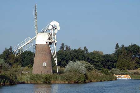
This Norfolk Broads walk includes many of the features that make this area so interesting including a fine example of a drainage water windmill. The route is generally easy to follow although there is some road walking so extra care needs to be taken with traffic. The start is the car park adjacent to the moorings on the south side of Ludham village (grid ref. TG391180).
After parking walk north to the main Yarmouth Road (A1062). Turn left and reaching the centre of the village turn left again down the southern end of High Street. This road soon becomes Staithe Road. After just under 600 metres take the driveway on your right (grid ref. TG388177). The tarmac driveway soon becomes a track and continues along the edge of a field to reach a track junction (grid ref. TG384180). Turn left here and continue past Ludham Hall to reach Hall Road (grid ref. TG381174). Turn right along Hall Lane and walk to the main Norwich Road (A1062). Turn left and continue to Ludham Bridge.
Do not cross the river but take the signed footpath on the right (grid ref. TG372170). This path leads along the River Ant. Stay beside the river for approximately 1.6 miles passing through the How Hill Fen Nature Reserve to arrive at a junction of paths just after the paths bear right away from the river bank (grid ref. TG368184). Turn left here and continue north following a clear path. You pass Turf Fen Drainage Mill on your left which is complete with a full set of sails. The path returns to the river bank and reached the Visitor Information Centre (grid ref. TG370190). Turn right immediately after and walk to a road (How Hill Road).
Turn right along How Hill Road and continue for 600 metres to reach a signed footpath on your right. This leads across a pasture to reach another lane (grid ref TG372185). Turn left along the lane and proceed to a T-junction at Whitegates (grid ref. TG378184). Cross thro ad and take the track slightly to your right which goes between houses. Entering a large field, the path goes half right to reach the Norwich Road (grid ref. TG382182). Turn left along the road. Ignore the first road on your right (Broad Reaches) and then turn right down Lover's Lane (grid ref. TG384182).
Continue along this lane which soon becomes a track to re-join your outward route. Reaching Staithe Road, turn left and continue to the centre of the village. Turn right along the Yarmouth road and take the first right back to the start.
Maps 

| Ordnance Survey Explorer OL40 | Sheet Map | 1:25k | BUY |
| Anquet OS Explorer OL40 | Digital Map | 1:25k | BUY |
| Ordnance Survey Digital Map Subscription | |||
| Latest Ordnance Survey Discounts | |||
Other walks nearby
| Walk 3694 | River Thurne & Hickling Broad from Potter Heigham | easy/mod | 6.4 miles |
| Walk 2128 | Stokesby & Muck Fleet from Fleggburgh | easy | 7.1 miles |
| Walk 2320 | Muck Fleet & River Bure | easy/mod | 8.7 miles |
| Walk 2239 | River Bure and Tunstall Dike from Acle | easy | 6.1 miles |
| Walk 2240 | The River Bure & Upton from Acle | easy | 5.0 miles |
| Walk 1855 | Horsey Circular | easy | 5.1 miles |
| Walk 1992 | Horsey Gap from Horsey | easy | 3.7 miles |
| Walk 3608 | Martham Ferry & River Thurne from West Somerton | easy | 4.0 miles |
| Walk 3609 | Winterton Ness from West Somerton | easy | 5.4 miles |
| Walk 2297 | Honing & East Ruston Circular | easy/mod | 6.4 miles |
