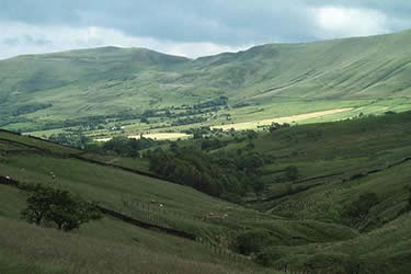
Rushup Edge & Edale from Mam Nick
Peak District Walk
Nat Park - Peak District - Great Ridge Castleton
County/Area - Derbyshire
Author - Mike Bexley
Length - 7.0 miles / 11.4 km Ascent - 1900 feet / 576 metres
Time - 5 hours 20 minutes Grade - moderate
Maps 

| Ordnance Survey Explorer OL1 | Sheet Map | 1:25k | BUY |
| Anquet OS Explorer OL1 | Digital Map | 1:25k | BUY |
| Ordnance Survey Landranger 110 | Sheet Map | 1:50k | BUY |
| Anquet OS Landranger 110 | Digital Map | 1:50k | BUY |
Walk Route Description
Click image to visit gallery of 3 images.
This Peak District walk starts from the Mam Nick car park near Castleton but can also be started from Edale Car Park or Edale railway station with references being made in the description of these alternative starting points. The walk could be graded as easy but for the long climb up from Edale to Mam Nick at the end of the day. Overall the route gives good views from Rushup Edge before dropping down to the picturesque dale above Edale and includes a section of the Pennine Way.
Start by climbing the steps from the back of Mam Nick car park (grid ref. SK123832) to reach the road. Do not climb up to Mam Tor but cross the road on the left to follow the path up to Rushup Edge, heading west. Keep to the high path along this edge, stopping to take in the view of the dale from Lord's Seat, a little bit of high ground on the right just after one of the stiles.
Return to the main upper path dropping down to a finger post sign (grid ref. 099829). Turn right here. This path descends to join a track called Chapel Gate with its broken tarred surface. Stay on this track to the bottom gate where you turn left to follow a wall on your right to the first stile (grid ref. 101840). Note a steep path comes down from the top of Chapel Track to this same point.
Now head north passing a small building on the left then down into the trees and over a stream following the sign to 'Dalehead', which consists of a couple of buildings. Part of one of these has been converted into a very small walkers shelter. Pass between the buildings over the stile and footbridge then left at the fence with it's conservation sign. Follow this fence round to the right. You are now walking over the railway tunnel serving the Manchester to Sheffield Line. On you right is a large spoil heap and a brick smoke chimney converted to a diesel vent.
Keep straight on behind a farm to reach a gate with white arrows directing you through the yard to the right of the building and out to the field ahead. Continue straight on, crossing a field with 'no footpath' signs on all the gates left and right. The path leads you to the corner of a barn. Do NOT cross over the fence here but walk up the field with the fence on your right to where some old gates and timber has been stacked, which you should cross over as best you can. Turn right down towards the farm and the notice regarding your rights of way to cross over the wall on the left using the steps. Then follow the footpath through some woods over a stream to the hamlet of Upper Booth with its friendly signs (grid ref 103853).
Cross over the road into the farm ahead turning right to follow the Pennine Way to Edale. This is the alternative start to the Pennine Way from Edale, with the finish some 270 miles away at Kirk Yetholm on the Scottish Borders. The path is pleasant walking through the meadows and on reaching Edale village turn right. Follow the road out of the village to pass the Information Centre on your left, the Railway Station on your right and a large car park with toilets on your left. All of these can be used as an alternative start for this route.
When you reach the T junction just past the last car park you should turn right and almost immediately left up the lane over the River Noe to pass Hardenclough Farm. Climbing steadily, stay on this lane to the end, which is marked by gates to a house - Greenlands. Climb over the stile on the left to follow the well worn path to reach the road on the northern side of Mam Nick. Head up the road and down the steps to the start.
Other walks nearby
| Walk 1688 | Old Dam & Sparrowpit from Mam Nick | moderate | 9.0 miles |
| Walk 1159 | Grindsbrook & Edale Head | moderate | 7.5 miles |
| Walk 1264 | Rushup Edge & Crowden Tower | moderate | 10.0 miles |
| Walk 1295 | Ringing Roger & Edale Cross | moderate | 10.0 miles |
| Walk 2595 | Castleton Great Ridge from Edale | moderate | 8.5 miles |
| Walk 2615 | The Kinder Edges | mod/hard | 18.0 miles |
| Walk 3350 | Kinder Scout Summit | moderate | 8.5 miles |
| Walk 1113 | Ringing Roger & Grindslow Knoll | moderate | 5.5 miles |
| Walk 1300 | Hope Cross & Ringing Roger | moderate | 8.0 miles |
| Walk 2378 | Rushup Edge & Mam Tor | moderate | 10.0 miles |
Recommended Books & eBooks
Dark Peak Walks
 Guidebook to 40 walks in the Dark Peak area of the Peak District National Park. 35 circular routes for most abilities, from 8km to 19km, around Edale, Marsden, Fairholmes, Baslow and Castleton, including Kinder Scout and Mam Tor, and 5 longer (25km to 45km) routes highlighting the best of the Gritstone Edges, High Moorland and Deep Valleys.
More information
Walking in the Peak District - White Peak East
 Guidebook describing 42 half-day and day walks in the limestone landscapes of Derbyshire's White Peak, part of the Peak District National Park. One of two volumes, this book covers the east of the region, with potential bases including Bakewell, Eyam, Castleton, Birchover, Matlock and Wirksworth.
More information
Messaging & Social Media
Message Walking Britain and follow the latest news.

Mountain Weather
Stay safe on the mountains with detailed weather forecasts - for iOS devices or for Android devices.