Bempton Cliffs from Flamborough
Yorkshire Wolds Walk
Region - Yorkshire Wolds
County/Area - East Yorkshire - Yorkshire Wolds
Author - Lou Johnson
Length - 6.7 miles / 10.9 km Ascent - 600 feet / 182 metres
Time - 4 hours 0 minutes Grade - easy/mod
Walk Route Description
Click image to see photo description.
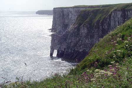
The coast around Flamborough Head is renowned for its superb cliffs, the highest of which are about 200 feet high. This walk is an 'out and back' route starting from the village of Flamborough where plenty of on street parking is available on Chapel Street (grid ref TA227706). There are also public toilets nearby.
After parking walk north on Chapel Street, which soon becomes Woodcock Road. After reaching a junction with a cul-de-sac (Craikewells) on your left look out for the signed footpath also on your left almost on this junction (grid ref. TA226708). Follow this track with houses to your left. The route does a left and right dog-leg before heading north with the hedge-line on your immediate right. The path passes a caravan park on your right and continues across fields to reach North Cliff (grid ref. TA224725).
Turn left along the cliffs immediately enjoying excellent views along this dramatic section of coast. In season the cliffs are full of nesting sea-birds including gulls, puffins and kittiwakes amongst others. The walking is easy and the path easy to follow. Like all sections of coast, many of the features have names and an OS Explorer map for the walk will help identify these more easily. After about two miles of cliff-top walking you will reach Bempton Cliffs where, a short way back from the coast, you will find an RSPB visitor centre, toilets and a picnic area.
The return route follows the outward route so you can put away the walk directions, relax and enjoy the view.
Maps 

| Ordnance Survey Explorer 301 | Sheet Map | 1:25k | BUY |
| Anquet OS Explorer 301 | Digital Map | 1:25k | BUY |
| Ordnance Survey Digital Map Subscription | |||
| Latest Ordnance Survey Discounts | |||
Other walks nearby
| Walk 2764 | Bempton Cliffs Circular | easy/mod | 5.8 miles |
| Walk 2264 | Bridlington & Flamborough Head | easy/mod | 6.8 miles |
| Walk 3428 | Boynton from Rudston Circular | easy | 6.5 miles |
| Walk 1433 | Martin & Metheringham circular | easy | 6.3 miles |
| Walk 1630 | Filey, Camp Dale & Hunmanby | moderate | 10.5 miles |
| Walk 3247 | Stockingdale and Muston from Hunmanby | easy/mod | 7.8 miles |
| Walk 2482 | Fordon and Dales Circular | easy/mod | 5.2 miles |
| Walk 1631 | Scarborough to Filey | moderate | 10.2 miles |
| Walk 3740 | Cowlam & Cottam Circular | easy/mod | 8.0 miles |
| Walk 1575 | Tophill Reservoir | easy | 3.0 miles |
