Cowlam & Cottam Circular
Yorkshire Wolds Walk
Region - Yorkshire Wolds
County/Area - East Yorkshire
Author - Lou Johnson
Length - 8.0 miles / 13 km Ascent - 800 feet / 242 metres
Time - 4 hours 50 minutes Grade - easy/mod
Walk Route Description
Click image to see photo description.
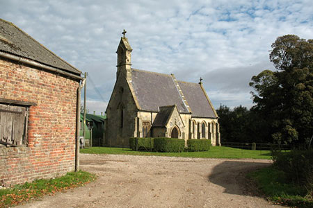
This walk in the Yorkshire Wolds explores typical scenery of the area with deep dry valleys cut into an upland Chalk plateau. The area has many deserted Medieval villages, and this route passes through two excellent examples. The two churches that served the villages are also passed, with Cowlam's 10th century church restored by the Victorians whilst Holy Trinity Church at Cottam has fallen into disrepair.
The walk starts from Cowlam where parking is available on a grass verge (grid ref. SE965655). Please park with consideration and avoid blocking access to fields and local properties. After parking cross the road and join the drive to Church Farm with fingerpost on the right-hand side of the drive. Continue ahead. At the first junction you can turn right to visit St. Mary's Church, or you can leave this option until you return from the walk. Continue ahead towards a gate where you fork right. In two hundred metres fork right again, pass through a gate, and descend into Cowlam Well Dale.
Continue down the dale, Phillip's Slack (another dale) joins from the left. Go through a gate and continue to the junction Cottam Well Dale (grid ref. SE978646). Pass through a further gate and swing right along the bottom of the dale keeping the hedge on your right. Continue down the dale to meet a lane (grid ref. SE972634). Turn left along the lane and continue for just under 800 metres to reach a fingerpost on the left (opposite a clear track on the right). Pass between the wooden bollards and continue on the path with a short climb to where the path widens to a track.
Follow this former Roman Road over the head of Lambert Dale (on your right) and continue uphill to join a concrete section which is part of the former WW2 RAF base, which saw very few aircraft movements. Continue ahead to reach a track junction on the brow of the hill (grid ref. SE997639). Turn left, pass barns on a remaining section of runway, and continue to where the track bends to the right (grid ref. SE997648). Turn left here and walk towards trees. Turn right and follow the edge of the field (trees to your left) and continue to the end of the trees where you turn left. Continue to a farm driveway where you cross to a small wooden gate.
Trend slightly right down to a second gate from where you have an excellent view of the site of Cottam's deserted medieval village. Continue slightly right passing below the decaying remains of Holy Trinity Church which should be on your right. Go through a kissing gate in a fence and then follow the path at the edge of fields to pass through the yard at Cottam Grange. Keep ahead along the drive for 600 metres. Turn left onto a track (grid ref. SE984662) and walk downhill. (If you reach the end of the drive retrace your steps back to this track.)
Where this track turns left, keep ahead with hedge on your left to a gate in the corner of the field. Once through the gate the path drops steeply into Phillip's Slack. Cross a tile in dale bottom and turn left down the dale for about a kilometre to reach Cowlam Well Dale used earlier in the walk. Turn through the gate a retrace your route up the dale and back to the start.
Maps 

| Ordnance Survey Explorer 300 | Sheet Map | 1:25k | BUY |
| Anquet OS Explorer 300 | Digital Map | 1:25k | BUY |
| Ordnance Survey Digital Map Subscription | |||
| Latest Ordnance Survey Discounts | |||
Other walks nearby
| Walk 3515 | Deepdale and the deserted village of Wharram St. Percy | easy | 5.0 miles |
| Walk 3434 | North Grimston, Birdsall & Wharram Percy | moderate | 12.1 miles |
| Walk 1738 | The deserted village of Wharram St Percy | easy | 2.7 miles |
| Walk 1990 | Settrington from North Grimston | easy/mod | 7.3 miles |
| Walk 2482 | Fordon and Dales Circular | easy/mod | 5.2 miles |
| Walk 2703 | Thixendale & Kirby Underdale | easy/mod | 8.5 miles |
| Walk 3428 | Boynton from Rudston Circular | easy | 6.5 miles |
| Walk 3349 | Pasture Dale, Frendal Dale and Horsedale from Huggate | easy/mod | 9.1 miles |
| Walk 1779 | Horse Dale, Holm Dale, Tun Dale and Frendal Dale from Huggate | easy/mod | 9.0 miles |
| Walk 2655 | Wayram To Fridaythorpe Circular | easy/mod | 7.5 miles |
