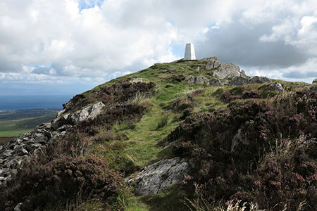
Carn Fadryn Hillfort from Garnfadryn
Llyn Peninsula Walk
Region - Llyn Peninsula
County/Area - Gwynedd - Llyn Peninsula
Author - Lou Johnson
Length - 1.5 miles / 2.4 km Ascent - 600 feet / 182 metres
Time - 1 hours 20 minutes Grade - easy
Walk Route Description
Click image to see photo description.
This short but energetic walk climbs from the village of Garnfadryn to the Iron Age hillfort of Carn Fadryn which lies in the centre of the Llŷn Peninsula northwest of Llanbedrog. Rising to 371 metres above sea level (1218 feet) the hill provides wide views across the surprisingly hilly peninsula. An evening walk to watch the sunset is particularly worthwhile but do allow time to descend the often-rocky path before darkness.
The start is the roadside parking area just west of the old chapel in Garnfadryn (grid ref. SH278345). After parking walk back past the chapel and turn left up a rising enclosed track with the slopes of Carn Fadryn rising ahead. At the end of the track pass through the gate and immediately turn right along the clear uphill path with the wall on your right. After 350 metres the path turns left away from the wall, steepens, and follows a winding path to the summit. The remains of the hill fort can be explored before taking in the panoramic view. To return, follow the route used in ascent.
Maps 

| Ordnance Survey Explorer 253 | Sheet Map | 1:25k | BUY |
| Anquet OS Explorer 253 | Digital Map | 1:25k | BUY |
| Ordnance Survey Digital Map Subscription | |||
| Latest Ordnance Survey Discounts | |||
Other walks nearby
| Walk 3382 | Llanbedrog Headland Circular | easy | 2.5 miles |
| Walk 3376 | Porth Dinllaen from Morfa Nefyn | easy | 4.5 miles |
| Walk 3371 | Mynydd Cilan from Hell's Mouth | moderate | 7.3 miles |
| Walk 1762 | Pwllheli, Llanbedrog & Abersoch | easy/mod | 9.0 miles |
| Walk 3375 | Mynydd Penarfynydd from Rhiw | easy | 3.3 miles |
| Walk 3044 | The Rivals (Yr Eifl) from Llithfaen | moderate | 4.5 miles |
| Walk 3374 | Porth y Nant & Nant Gwrtheryn Circular | easy/mod | 3.5 miles |
| Walk 3339 | Mynydd Anelog & the Whistling Sands | easy | 4.5 miles |
| Walk 3372 | Mynydd Mawr & Porth Meudwy Circular | moderate | 7.0 miles |
| Walk 3377 | Pen y Cil & Porth Meudwy from Mynydd Mawr | moderate | 5.7 miles |
Recommended Books & eBooks
Snowdonia: 30 Low-level and easy walks - South
 Guidebook describing 30 walks in Snowdonia, Wales. Routes are mostly low level and on clear paths and showcase the region's beautiful scenery and rich history and culture. Part of a 2-volume set, this southern volume includes Trawsfynydd, Bala, Dolgellau, Machynlleth, the Harlech Coast and the valleys of the Mawddach and Dyfi.
More information
The Wales Coast Path
 A single guidebook to walking the whole Wales Coast Path - 1400km (870 miles) the length of Wales from Chester to Chepstow, including Anglesey, described in 57 stages. The route passes through the Snowdonia and Pembrokeshire National Parks and many AONBs and can be linked with the Offa's Dyke Path for a complete circuit of Wales.
More information
