Crugyn Ci, Esgair Perfedd & Penygarreg - Elan Valley
Cambrian Mountains Walk
Region - Cambrian Mountains
County/Area - Powys - Cambrian Mountains
Author - Lou Johnson
Length - 7.5 miles / 12.2 km Ascent - 1400 feet / 424 metres
Time - 5 hours 10 minutes Grade - moderate
Walk Route Description
Click image to visit gallery of 12 images.
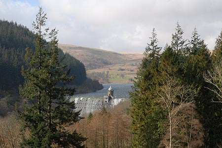
The hills and valleys to the west of the pleasant town of Rhayader offer some excellent walking. Rising to just over 2000 feet, the rounded hills contrast with the valleys where a series of three reservoirs are the result of dams completed in 1904, and, in an adjacent valley, a further reservoir finished in 1952. Providing water for Birmingham the reservoirs perhaps add to the scenic interest and provide an area of recreation managed by Welsh Water and referred to as the Elan Valley.
This walk starts in the small car park (Grid ref. SN914672) at the head of Garreg-ddu Reservoir. This can be reached by following the road into the valley past the excellent visitor centre and continuing straight ahead at the junction where the road goes left to the Claerwen Dam. After parking exit the car park onto the road and turn left over the river bridge. Follow the road as it turns sharp right and look out for an unmarked path climbing through the woods on your left. Take this path, soon crossing a track, and continue uphill to a rough lane (Grid ref. SN917673). Turn left along the higher track that provides access to Penygarreg Farm. The path has been diverted near the farm so follow the new route to reach a junction of bridleways (Grid ref. SN911676). Turn right here and follow the bridleway as it climbs gently through fields to reach open country.
The bridleway is hard to follow in its early stages as it crosses the flank of Esgair Penygarreg in a north-westerly direction but becomes clearer as you climb higher. It is better to leave the main path and walk across grass to the summit of Crugyn Ci (533m.) with its trig column. The view from here is good especially east towards Rhayader and beyond and provides a good excuse for a short break. Continue by regaining the path and following this at descends towards the mountain road from Rhayader to Cwmystwyth. Do not ford the stream instead remain on the west bank and walk north across rough and sometimes wet ground to reach the bridleway crossing the slopes of Esgair Perfedd. (Note - if the water level in the stream is low then it is easier to walk up the road.)
Reaching the bridleway (grid ref. SN928699) walk westwards past the Roman Camp of which there is little evidence on the ground. There might be some confusion about which path to take as there are a number of parallel routes. The best advice is to stay on the most obvious path ensuring that you carry on climbing across the flank of Esgair Perfedd. The path swings towards the north and reaches a junction of routes (grid ref. SN911698 approx). Turn left here. (It is worth noting the OS Explorer map is not very good at showing paths on this section of the route.) The onward path becomes easier to follow from this point and soon you will start to descend to the shores of Craig Goch Reservoir.
You soon arrive at the dam (Grid ref. SN894686). Walk through the small parking area, past the information board and continue through the gate to join a broad path. This path was once the track-bed of the railway built to aid construction of the dams. The going is good with excellent views across Penygarreg Reservoir with its tree clad island. Reaching the dam leave the main path and turn right and descend steeply down a narrower path to the footbridge over the river. Cross the bridge and turn left. In a few minutes you will be back at the start having enjoyed a great day in the quiet hills of this relatively undiscovered part of Wales that might have been part of the ill-fated proposal for a Cambrian Mountains National Park.
Maps 

| Ordnance Survey Explorer 200 | Sheet Map | 1:25k | BUY |
| Anquet OS Explorer 200 | Digital Map | 1:25k | BUY |
| Ordnance Survey Digital Map Subscription | |||
| Latest Ordnance Survey Discounts | |||
Other walks nearby
| Walk 3674 | Claerwen Valley & Dam from Dolymynach Reservoir | moderate | 7.4 miles |
| Walk 2498 | Gorllwyn circuit, Elan Valley | easy/mod | 6.8 miles |
| Walk 2472 | Abbeycwmhir Circular | easy/mod | 7.2 miles |
| Walk 2736 | Teifi Pools from near Strata Florida | easy/mod | 6.2 miles |
| Walk 1365 | Strata Florida to Tregaron | moderate | 9.5 miles |
| Walk 3086 | Pen y Garn from near Devil's Bridge | easy/mod | 6.8 miles |
| Walk 1898 | Severn Valley from Llanidloes | moderate | 11.3 miles |
| Walk 1363 | The Elephant Walk from Tregaron | easy/mod | 5.5 miles |
| Walk 1102 | Plynlimon & Nant-y-Moch Reservoir | hard | 11.0 miles |
| Walk 1304 | Plynlimon | moderate | 5.0 miles |
Recommended Books & eBooks
The Cambrian Way
 Guidebook to the Cambrian Way, a challenging three-week mountain trek through Wales from Cardiff to Conwy. The 470km un-waymarked route is presented from south to north. Often sticking to long, beautiful ridgelines, it crosses wild and rugged terrain and visits many of Wales's highest mountains, including Snowdon.
More information
