Teifi Pools from near Strata Florida
Cambrian Mountains Walk
Region - Cambrian Mountains
County/Area - Powys - Cambrian Mountains
Author - Lou Johnson
Length - 6.2 miles / 10.1 km Ascent - 1100 feet / 333 metres
Time - 4 hours 10 minutes Grade - easy/mod
Walk Route Description
Click image to see photo description.
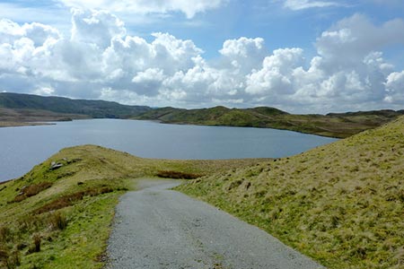
This walk in the Cambrian Mountains crosses wild upland country of Mid-Wales to explore a series of lakes known as the Teifi Pools, which lie to the east of Strata Florida. The route passes close by to Llyn Bach, Llyn Egnant and Llyn Teifi and if you have time other smaller lakes can be explored lying a short distance off the recommended walk. This is a walk where a 1:25000 OS map will prove useful as there is one section that requires careful navigation after leaving the shores of Llyn Teifi.
The start is the small parking area (grid ref. SN769655) just before Tyncwm Farm at the end of the of a minor road leading almost due west from Strata Florida. From the lane take the signed bridleway on the north side of the lane signed to 'Teifi Pools'. Follow the path across a bridge and then bear right across a field to reach a track (grid ref. SN771656). Turn left and follow the track over a stream (Nant Egnant). The path climbs steadily to the col at the head of Cwm Egnant. Shortly after the path starts to descend, turn left onto a path which heads north via a gate to reach the dam wall of Llyn Egnant (grid ref. SN790666).
Continue north along a tarmac service road along the western side of Llyn Egnant. This leads to a road (grid ref. SN794680). Turn left and after about 800 metres, turn left along a track (grid ref. SN786681) signed to 'Llyn Teifi'. Stay on this track until you reach a gate by the dam wall (grid ref. SN780674). Careful map reading is now required. Take the path to the right of the gate. The path is feint in places and bears to the right of an outcrop. The path soon turns to the left to reach a stile and a stream (the infant River Teifi) at grid ref. SN778673).
Walk down the valley with the stream to your right. Reaching a grassy track (grid ref. SN777670), turn right down the valley to reach Frongoch Farm (grid ref. SN765667). Turn right and then left through the farmyard and follow the farm access track south to Troed-y-rhiw (grid ref. SN762661). Just after the buildings, take the gate on the left and follow a grassy path which soon bears left around the hillside and continues to reach a road (grid ref. SN766656). Bear left along this road and back to the start.
Maps 

| Ordnance Survey Explorer 187 | Sheet Map | 1:25k | BUY |
| Anquet OS Explorer 187 | Digital Map | 1:25k | BUY |
| Ordnance Survey Explorer 213 | Sheet Map | 1:25k | BUY |
| Anquet OS Explorer 213 | Digital Map | 1:25k | BUY |
| Ordnance Survey Digital Map Subscription | |||
| Latest Ordnance Survey Discounts | |||
Other walks nearby
| Walk 1365 | Strata Florida to Tregaron | moderate | 9.5 miles |
| Walk 1363 | The Elephant Walk from Tregaron | easy/mod | 5.5 miles |
| Walk 1362 | Tregaron & Cors Caron circular | easy | 4.0 miles |
| Walk 3086 | Pen y Garn from near Devil's Bridge | easy/mod | 6.8 miles |
| Walk 1361 | Tregaron & Twm Town circular | easy | 3.5 miles |
| Walk 1364 | Tregaron & Llandewi Brefi circular | easy/mod | 4.5 miles |
| Walk 1367 | Cwm Berwyn from Tregaron | moderate | 11.0 miles |
| Walk 3674 | Claerwen Valley & Dam from Dolymynach Reservoir | moderate | 7.4 miles |
| Walk 2498 | Gorllwyn circuit, Elan Valley | easy/mod | 6.8 miles |
| Walk 1366 | Pentre Bach circular | easy/mod | 9.5 miles |
Recommended Books & eBooks
The Cambrian Way
 Guidebook to the Cambrian Way, a challenging three-week mountain trek through Wales from Cardiff to Conwy. The 470km un-waymarked route is presented from south to north. Often sticking to long, beautiful ridgelines, it crosses wild and rugged terrain and visits many of Wales's highest mountains, including Snowdon.
More information
