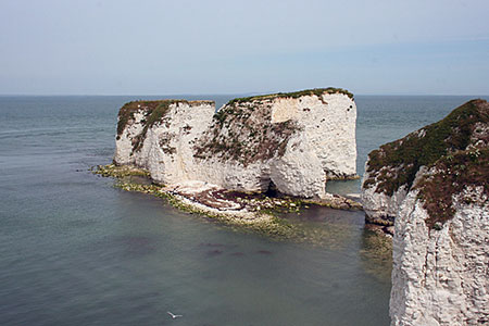
Agglestone & Old Harry Rocks from Studland
Jurassic Coast Walk
Region - Jurassic Coast
County/Area - Dorset
Author - Lou Johnson
Length - 6.4 miles / 10.4 km Ascent - 800 feet / 242 metres
Time - 4 hours 0 minutes Grade - easy/mod
Maps 

| Ordnance Survey Explorer OL15 | Sheet Map | 1:25k | BUY |
| Anquet OS Explorer OL15 | Digital Map | 1:25k | BUY |
Walk Route Description
Click image to see photo description.
This walk from Studland explores the area west of the village with the route including the Agglestone and a section of Dorset's Jurassic Coast. The walk follows well-trodden paths and provides an excellent introduction to the area.
The start is the South Beach car park at Studland (grid ref. SZ037825). After parking exit the car park and turn left. Almost immediately turn left onto a path signed to the church. Continue through the gate and churchyard. Keep the church on your right and continue ahead to reach School Lane. Turn right and continue to a crossroads. Go straight across into Heath Green Road. After 200 metres turn right onto a signed bridleway to Godlingston Heath.
Ignore side paths and keep to the main path, which narrows to reach a path junction where you turn right. Continue to a track and turn left. Continue onto Godlingston Heath. Cross a footbridge and turn left towards Agglestone. At the next fork, bear left and continue into open country. You can soon the Agglestone ahead and this is the next objective. Bear left at the next fork and head for the large sandstone rock.
Pass the rock and keep ahead, cross a path junction, and continue through two gates to meet a wider track. Go right here and shortly after bear right at a fork. Cross the golf course to reach Studland Road (grid ref. SZ017819). Cross the road and bear left to cross a tile on the right. Cross another fairway and head for the trees where a marker post indicates the path. Continue through the trees and drop left down to a stile. Bear right across bracken and grass to reach a stile and a road (grid ref. SZ018815).
Turn left along the road for 300 metres. Just after a small parking area on the left, cross the road onto a signed bridleway (sign in the trees on the left). The track climbs onto Ballard Down before bearing left to reach an obelisk. Continue ahead past the obelisk enjoying views to Swanage and Poole and as you make progress to the Isle of Wight. Continue ahead along the broad ridge to reach the OS trig point. Just after bear right to a gate and continue to join the South West Coast Path.
Follow the coast path (sea on your right) and continue around Ballard Point following a clear path north-east down to Handfast Point where you will see the Pinnacles and Old Harry Rocks. The path swings to the left, passes through trees and soon joins a tarmac track. Continue ahead to reach Watery Lane. Turn right past the toilets on your right and past the Bankes Arms back to the car park which is on your left.
Other walks nearby
| Walk 1613 | Studland & Old Harry Rocks | easy/mod | 8.5 miles |
| Walk 2579 | Purbeck Coast from Swanage | moderate | 10.0 miles |
| Walk 3286 | Dancing Ledge & Durlston Head from Langton Matravers | easy/mod | 7.0 miles |
| Walk 2925 | St Aldhelm's Head near Worth Matravers | easy | 4.1 miles |
| Walk 2145 | Houns-tout Cliff from Kingston | easy | 3.5 miles |
| Walk 1331 | Kimmeridge & Tyneham | easy/mod | 6.8 miles |
| Walk 1534 | Swyre Head & Tyneham Cap from Kimmeridge | moderate | 11.8 miles |
| Walk 1995 | Houns-tout & Swyre Head from Kimmeridge | moderate | 8.7 miles |
| Walk 2568 | Egmont Point & Kimmeridge Bay from Tyneham | moderate | 14.0 miles |
| Walk 1533 | Gad Cliff, Povington Hill & Tyneham | easy/mod | 4.5 miles |
Recommended Books & eBooks
South West Coast Path Map Booklet - Minehead to St Ives
 Map of the northern section of the 630 mile (1014km) South West Coast Path National Trail. Covers the trail from Minehead to St Ives along the north Devon and Cornish coastline. This convenient and compact booklet of Ordnance Survey 1:25,000 maps shows the route, providing all of the mapping you need to walk the trail in either direction.
More information
Walking the Jurassic Coast
 This guidebook includes 30 walks on the Jurassic Coast of Devon and Dorset. Covering the coast between Exmouth and Bournemouth, these delightful routes range from 3 to 16 miles (5 to 24km), exploring and explaining the spectacular geology of this World Heritage area with clear, easily understood descriptions, cross-sections and timelines.
More information
Messaging & Social Media
Message Walking Britain and follow the latest news.

Mountain Weather
Stay safe on the mountains with detailed weather forecasts - for iOS devices or for Android devices.