Wild Boar Fell from Pendragon Castle
Cumbria Walk
County/Area - Cumbria - Eden Valley Mallerstang
Author - Lou Johnson
Length - 8.3 miles / 13.5 km Ascent - 1800 feet / 545 metres
Time - 6 hours 0 minutes Grade - moderate
Walk Route Description
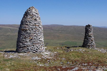
Click image to see photo description.
The valley of Mallerstang, south of Kirkby Stephen, is one of my favourite places for walking. This Cumbria walk starts from near Pendragon Castle and includes an ascent of Wild Boar Fell which features a great view down to Sand Tarn, some impressive cairns and most of all wonderful views in all directions. A visit to the ruins of Pendragon Casle can be completed either at the start of end of the walk.
Parking is available in a layby on the B6259 or on the grass verge (grid ref. NY782018) on Tommy Road just before crossing the River Eden. After parking walk along the lane. Cross the river over Castle Bridge. Follow the lane uphill, over a cattle grid and continue on the lane. The lane curves left and then right. Leave the lane at a fingerpost (grid ref. NY776029) to follow a track that soon crosses the railway. You soon reach a gate in a drystone wall. Do not go through the gate. Follow the vague path that follows the wall (on your left).
Stay with the wall where it bends left and continue along the wall. Where the wall bends sharp left continue ahead to ascend the Middle Fell with its cairn. Ahead can be seen Wild Boar Fell. The path continues in a southerly direction descending to an old wall. Keep the wall on your right to reach a junction with the Pennine Bridleway (grid ref. NY766000). Go straight across the bridleway and head up the steep path. This is rough in places but by following the ridge you soon reach the cairn on the Nab (grid ref. NY764992).
From here head in a south-westerly direction for 700 metres to reach the trig point on Wild Boar Fell. A brief diversion to the west will provide a view down to Sand Tarn and across to the Howgill Fells. From the trig point bear south-east to reach the edge of the crags. Turn left along the edge passing a number of impressive cairns. After exploring the area, head north to the Nab and retrace your route back down to the Pennine Bridleway.
Turn right and follow the clear descending track under the railway and on to Hazelgill Farm (grid ref. NY780998). Just before reaching the farm turn left onto a signed footpath. This path parallels the railway on your left. Reaching Deep Gill, go left of the barn and head north to Sycamore Tree Farm. Join their access track down to some barns. Turn left onto the waymarked Pennine Journey path. The path bears left in front of Shoregill and then goes right (signed). Stay on the path ahead across several fields to reach Tommy Road by Castle Bridge. Turn right to return to the start.
Maps 

| Ordnance Survey Explorer OL19 | Sheet Map | 1:25k | BUY |
| Anquet OS Explorer OL19 | Digital Map | 1:25k | BUY |
| Ordnance Survey Digital Map Subscription | |||
| Latest Ordnance Survey Discounts | |||
Other walks nearby
| Walk 1383 | Pendragon Castle | easy | 2.3 miles |
| Walk 1382 | Mallerstang circular | easy/mod | 7.0 miles |
| Walk 1160 | Wild Boar Fell & Swarth Fell | moderate | 7.0 miles |
| Walk 1389 | Fell End Clouds | easy | 3.0 miles |
| Walk 2756 | Wild Boar Fell (western approach) | moderate | 7.0 miles |
| Walk 1341 | Nine Standards Rigg | moderate | 6.0 miles |
| Walk 1384 | Mallerstang Edge | moderate | 8.8 miles |
| Walk 1386 | Hartley Birkett & Nine Standards Rigg | easy/mod | 4.5 miles |
| Walk 1388 | Kirkby Stephen & Hartley Circular | easy/mod | 5.0 miles |
| Walk 2538 | Nateby & Waitby Common from Kirkby Stephen | easy/mod | 6.2 miles |
Recommended Books & eBooks
Walking the Lake District Fells - Langdale
 Part of the Walking the Lake District Fells series, this guidebook covers a wide range of routes to 25 Lakeland summits that can be climbed from the Great Langdale valley, Ambleside and Grasmere, with highlights including Scafell Pike, Bowfell, the Langdale Pikes and Helm Crag (the Lion and the Lamb). Includes suggestions for longer ridge routes.
More information
The Cumbria Way
 A guidebook to the 73 mile Cumbria Way, an easy long-distance walk though the heart of the Lake District National Park, from Ulverston in the south to Carlisle in the north, with good transport links to either end. The route is largely low-level but this guide offers alternative mountain days to climb some of the famous fells en route.
More information
