Wansfell Pike & Wansfell from Ambleside
Lake District Walk
Nat Park - Lake District - Lake District Eastern Fells
County/Area - Cumbria
Author - Lou Johnson
Length - 7.5 miles / 12.2 km Ascent - 1800 feet / 545 metres
Time - 5 hours 30 minutes Grade - easy/mod
Walk Route Description
Click image to visit gallery of 6 images.
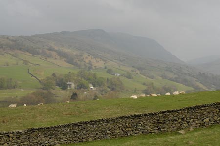
Wansfell overlooks the town of Ambleside and for many years its ascent has proved popular with walkers. The first time I walked this fell the approach path was in a sorry state, very muddy and slippery and eroding fast. Since then significant improvements to the path have been made using rock and the former erosion has all but disappeared. Today Wansfell makes an excellent Lake District circular walk which provides some fine views of Lakeland scenery.
The walk starts in Ambleside (grid ref. NY375045) where parking can be a headache at busy times of the year. The walk starts near the Salutation Hotel in the centre and you have a choice of initial routes. You can either follow Stockghyll Lane uphill or alternatively follow the footpath that runs alongside the ghyll towards Stockghyll Force waterfall exiting onto the lane where the footpath ends. Whichever way you start you end up on Stockghyll Lane which sees very little traffic especially as you climb away from the houses. At grid ref. NY385045 take the signed footpath on your right that leads across fields towards Wansfell. The path is good and progress fast with improving views towards the Langdales and Fairfield in particular.
As the summit nears, the path passes through a rocky patch and soon leads to the highest point (482m.) at this end of the fell from where the views are mainly to the west. To reach the highest elevation on Wansfell ignore the main path dropping down to Troutbeck and head northeast alongside the ridge wall to the highest point (487m.) which is marked by a cairn. Despite the gain in height the view is less interesting although you can claim to have visited the real summit - a feat achieved by only a few of the walkers who sent out to ascend Wansfell.
To continue follow the developing path southeast. This path roughly follows a wall but then takes a shortcut to shadow another wall heading roughly SSW. After a short wall the path has developed enough and becomes easy to follow. The path leads into a walled lane - Nanny Lane (grid ref. NY403045), which is followed all the way down to a lane in Troutbeck. Turn right along the lane and walk through the village as far as the Post Office, the only source of refreshments on the walk but with limited opening times.
Just past the Post Office, the lane forks. Take the right hand lane (Robin Lane) which immediately starts to climb. The lane soon becomes a track and you swing in a large loop around the fellside to reach a junction of tracks (grid ref NY397023). Bear half left here following the signs for Ambleside dropping down to cross a stream before climbing once more to join the access road to High Skelghyll Farm.
Continue past the farm. The track soon enters delightful Skelghyll Wood. Continue following the main track ignoring tracks to the left as these drop down in to the valley too soon and leave you with an unpleasant walk along the main A591. The main track leaves the wood and you can see Ambleside ahead.
Maps 

| Ordnance Survey Explorer OL7 | Sheet Map | 1:25k | BUY |
| Anquet OS Explorer OL7 | Digital Map | 1:25k | BUY |
| Ordnance Survey Digital Map Subscription | |||
| Latest Ordnance Survey Discounts | |||
Other walks nearby
| Walk 2026 | Loughrigg from Pelter Bridge near Rydal | easy/mod | 4.0 miles |
| Walk 3034 | Red Screes & Other Fells from Ambleside | mod/hard | 10.0 miles |
| Walk 3697 | Loughrigg Fell from Skelwith Bridge | easy/mod | 4.5 miles |
| Walk 1823 | Fairfield Horseshoe & Loughrigg from High Close | mod/hard | 14.0 miles |
| Walk 1472 | Alcock Tarn & Rydal Water | easy/mod | 7.0 miles |
| Walk 1565 | Rydal Water & Grasmere circular | easy/mod | 6.0 miles |
| Walk 1682 | Rydal Water & Grasmere | easy/mod | 5.5 miles |
| Walk 2715 | Skelwith Bridge & Loughrigg | easy/mod | 5.5 miles |
| Walk 1684 | Lingmoor Fell & Langdale | easy/mod | 7.0 miles |
| Walk 1141 | Elterwater circular | easy/mod | 4.0 miles |
Recommended Books & eBooks
Walking the Lake District Fells - Patterdale
 Part of the Walking the Lake District Fells series, this guidebook covers a wide range of routes to 35 Lakeland summits that can be climbed from Ambleside, Grasmere and Patterdale and the Thirlmere and Ullswater valleys, with highlights including Helvellyn and Fairfield. Suggestions for longer ridge routes are also included.
More information
Lake District: Low Level and Lake Walks
 This guidebook describes 30 of the best low-level walks in the Lake District. From delightful wooded glades and sparkling tarns, to waterfalls and glacier-carved valleys towered over by craggy mountains. The walks described aim to seek out the best walking that the lower areas of the Lake District have to offer.
More information
