Ben Vrackie & Meall an Daimh from Pitlochry
Perth and Kinross Walk
County/Area - Perth and Kinross
Author - Lou Johnson
Length - 8.0 miles / 13 km Ascent - 2800 feet / 848 metres
Time - 6 hours 50 minutes Grade - mod/hard
Walk Route Description
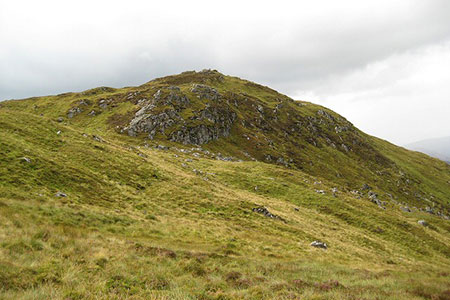
Click image to see photo description.
Starting from the outskirts of Pitlochry at Moulin this walk follows the 'tourist path' to the summit of Ben Vrackie (841 m.). The onward route descends to the broad ridge heading east to Meall an Daimh. From this minor summit a descent over pathless hillside leads to the Bealach Path. The remaining route follows a clear path to re-join the 'tourist path' for a leisurely walk back to the start.
The upper car park (grid ref. NN994598) signed from the Moulin Hotel on the northern outskirts of Pitlochry is the starting point of this walk. In fine weather you may have to use the lower car park. The 'tourist' route which is signed from the car park and at intermediate path junctions along the way. Initially the route passes through pleasant woodland beside the Moulin Burn.
Leaving the woodland behind, the path reaches open hillside. Please take note of the reminders listed on the notice about being properly equipped for this walk especially with regard to weather and equipment. The path climbs steadily across heather moors. You soon reach the junction with the Bealach Path (grid ref. NN943614), which is used for the return. Keep right here and continue over a bealach between the minor summits of Creag Bhreac on your right and Stac an Fheidh on your left.
After losing some height, the path starts to climb again passing Loch a' Choire on your left. Cross the dam and start a steeper section on a good path. Height is gained quickly as you head up the southern flank of Ben Vrackie. Reaching the point where the path turns left, and the hardest section is over with only a short distance to the summit. The summit has an OS trig column and a topograph which details the landmarks visible from the summit. The views are extensive including Rannoch Moor and the Glencoe area.
Before leaving the summit, it is worth familiarising yourself with the ridge running north-west to Meall an Daimh. Leaving the crowds behind, initially descend north over pathless ground veering north-west to join the broad ridge. In places there is a feint path but if in doubt keep to the highest point of the ridge. Before reaching Meall an Daimh's summit, you cross a minor top which leads to the final climb to the tup. The retrospective view back to Ben Vrackie offers a different perspective of this hill.
From Meall an Diamh descend southwest over pathless ground. Walk parallel to the stone wall to reach a track (grid ref. NT932638). Turn left and follow the clear path downhill. Reaching a junction with the Bealach Path (grid ref. NT933629), bear left and head uphill to the Bealach na Searmoin. Continue down to reach the 'tourist path' and turn right. Retrace your steps across the moor and through woodland back to the start.
Maps 

| Ordnance Survey Explorer OL49 | Sheet Map | 1:25k | BUY |
| Anquet OS Explorer OL49 | Digital Map | 1:25k | BUY |
| Ordnance Survey Digital Map Subscription | |||
| Latest Ordnance Survey Discounts | |||
Other walks nearby
| Walk 3288 | Ben Vrackie from Moulin (Pitlochry) | moderate | 5.0 miles |
| Walk 3354 | Glen Banvie and Blair Castle from the Falls of Bruar | moderate | 11.3 miles |
| Walk 2356 | The Cairnwell ridge from Glenshee Ski Centre | mod/hard | 9.3 miles |
| Walk 1046 | Schiehallion via main path | moderate | 6.4 miles |
| Walk 1119 | Ben Macdui & Carn a' Mhaim | hard | 19.0 miles |
| Walk 1864 | Glen Quoich & Glen Lui (near Braemar) | moderate | 10.0 miles |
| Walk 3108 | Creag Choinnich circular | easy/mod | 4.0 miles |
| Walk 2706 | Morrone (Morven) | moderate | 7.4 miles |
| Walk 1968 | Loch Turret to Comrie | easy/mod | 8.0 miles |
| Walk 3747 | Ben Chonzie from Loch Turret | mod/hard | 10.0 miles |
