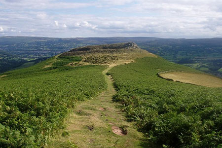
Table Mountain from Crickhowell
Brecon Beacons/Bannau Brycheiniog Walk
Nat Park - Brecon Beacons - Brecon Beacons East
County/Area - Powys
Author - Lou Johnson
Length - 5.0 miles / 8.1 km Ascent - 1200 feet / 364 metres
Time - 3 hours 40 minutes Grade - easy/mod
Walk Route Description
Click image to see photo description.
This Powys circular walk in the Brecon Beacons National Park starts from Crickhowell (Crughywel) and follows the Beacons Way to the summit of Table Mountain which is the site of the Iron Age hill fort of Crug Hywel. Rising to 451 metres above sea level, Table Mountain offers an excellent view down to Crickhowell.
The start is main car park in Beaufort Street, Crickhowell (grid ref. SO219184). Exit the car park onto the A40 (Beaufort Street) and turn right soon passing the Tourist Information Centre which is a useful source of information. Stay on the A40 to pass the Bear Hotel and a Shell filling station. Turn right at the next junction up Llanbedr Road. Follow this road uphill passing a grassy are on the right. At the end of the grass turn left Oakfield Drive (grid ref. SO220188).
As you walk along Oakfield Drive you get a good view up to Table Mountain on your right. Follow Fairfield Drive and follow it round to the left (do not go up Cwmbeth Close by mistake). Just before no. 56, turn right up an alley. Cross two roads and continue up to reach some gates. Take the stile signed "Beacons Way". Stay on the Beacons way for about 2.5 kilometres steadily climbing up the pretty valley of Cwm Cumbeth. The climb is steady but never steep and you soon reach a sheepfold on the edge of open country.
Turn right along the wall staying on the Beacons Way for the final steady climb for a kilometre to reach the summit area of Table Mountain (grid ref. SO225208). After the climb you can now relax and enjoy the view and maybe explore the remaining features of the Iron Age hillfort. Say goodbye to the Beacons Way which now heads north. From the summit area continue to the second cairn and then bear left through a ruined stone gateway. Head downhill to turn right onto a grassy path which curves around the lower slopes of the hill.
After 500 metres, turn left (grid ref. SO224203) guided by yellow arrows. The descending path crosses several fields for about 750 metres to reach a gate across the path (grid ref. 225196). Do not go through the gate but turn right through a metal gate and follow the edge of a field to Wern Farm (grid ref. SO223196). Reaching the farm drive, turn left and head downhill to reach Great Oak Road. Turn right and after 240 metres fork right down Llanbedr Road and retrace your steps to the A40 and the car park used at the start of the walk.
Maps 

| Ordnance Survey Explorer OL13 | Sheet Map | 1:25k | BUY |
| Anquet OS Explorer OL13 | Digital Map | 1:25k | BUY |
| Ordnance Survey Digital Map Subscription | |||
| Latest Ordnance Survey Discounts | |||
Other walks nearby
| Walk 3134 | The Llangatwg Escarpment from near Crickhowell | moderate | 6.5 miles |
| Walk 1271 | Sugar Loaf circular | moderate | 6.0 miles |
| Walk 1664 | The Sugar Loaf | easy | 3.5 miles |
| Walk 1415 | Iron Mountain Trail - 'Llwybr Mynydd Haearn' - Part 1 | easy/mod | 7.5 miles |
| Walk 1512 | Iron Mountain Trail - 'Llwybr Mynydd Haearn' - Part 2 | easy/mod | 5.0 miles |
| Walk 3435 | Keeper's Pond & Blorenge | easy/mod | 7.5 miles |
| Walk 2670 | Ysgyryd Fawr (The Skirrid) near Abergavenny | easy/mod | 3.5 miles |
| Walk 1237 | Cwmyoy & Hatterrall Hill from Llanthony Priory | moderate | 10.0 miles |
| Walk 3203 | Vale of Ewyas from Llanthony Abbey | moderate | 10.7 miles |
| Walk 3342 | The Hatterall Ridge from Llanthony Priory | very hard | 10.0 miles |
Recommended Books & eBooks
The Cambrian Way
 Guidebook to the Cambrian Way, a challenging three-week mountain trek through Wales from Cardiff to Conwy. The 470km un-waymarked route is presented from south to north. Often sticking to long, beautiful ridgelines, it crosses wild and rugged terrain and visits many of Wales's highest mountains, including Snowdon.
More information
Walking on the Brecon Beacons
 45 circular day walks are described in this guidebook to the Brecon Beacons National Park. From west to east, Mynydd Du, Fforest Fawr, the Brecon Beacons and the Black Mountains these mountain and valley routes offer many options, highlighting the natural features. The walks described explore dramatic waterfalls, wooded gorges and upland valleys.
More information
