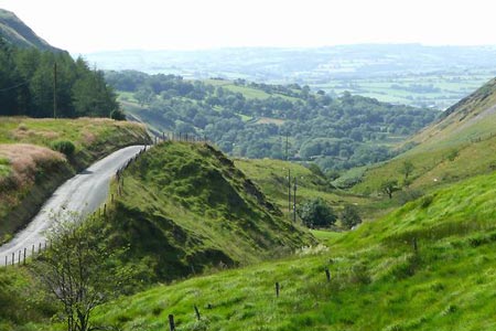
Cwm Berwyn from Tregaron
Cambrian Mountains Walk
Region - Cambrian Mountains
County/Area - Ceredigion
Author - Dafydd Wyn Morgan
Length - 11.0 miles / 17.9 km Ascent - 1400 feet / 424 metres
Time - 6 hours 50 minutes Grade - moderate
Walk Route Description
Click image to see photo description.
This walk crosses mostly rougher terrain but is a complete mix from rough pathless upland, through bridleways across fields to sections of tarmac/concrete track. There is road walking at the start/end of the route. Please note that the section passing through the Forestry Commission Wales Cwm Berwyn Plantation may be closed to forest operations. All warning signs must be obeyed for your own safety. Dates where access is prohibited can be found on the Countryside Council for Wales website.
1 - From the Talbot Hotel, turn right and walk up past the turning to the new pay and display town car park. Continue out of town until you reach a white bungalow on the right called Llygad-y-rhiw. Take the next left after this (dead-end-road) and cross a bridge over a small stream.
2 - Continue following this road until you cross another stone bridge over a much larger stream. Shortly after this, turn left into the driveway of Brynhownant. After roughly 100m, bend right and go gently uphill through the farmyard. Emerge on a short grassy track with several exits - continue straight ahead through a small wooden gate into the field ahead, following the fence line uphill bear left to join a wide vehicle track exiting from the field on the right.
3 - Continue through a metal gate (ignoring the one you pass on your right) and uphill past some gorse bushes (keeping these closely to your right). Pass through a wooden gate across the holloway (sunken track) to your left and continue following as close as possible to the line of gorse bushes (now on your left). In the far corner of the field there is a small gap in the gorse bushes, leading to a wooden gate near the field corner. Open this, and soon rejoin the holloway, now mercifully clear of gorse bushes. Continue along this (now running along a broad grassy ridge divided into fields), and through a gateway and a metal gate. A final rusty gate marks open country ahead.
4 - Follow vehicle tracks and past a rusty field gate to your right, over boggy ground to reach a further gate in a boggy corner. Go through this to stay in access land (it swaps to the right-hand side of the fence here), and continue ahead following the line of a greasy, stony "stream" until you are roughly level with the farm ruins of Bryn-coch on the left. Fork right over open ground towards a clear green path leading diagonally uphill until you are roughly level with a few tress surrounding a ruined barn to your right. Veer right towards there, initially on pathless ground, crossing a peat leat before a wire fence. Shortly after this, a vague sheep track emerges leading out of a access land and just right of the farm ruins.
5 - Follow narrow walled track beyond the farm ruins, then head for a lone tree in the far right corner of the field. Pass through a ruined gateway beside this, and continue ahead with a ruined wall/further ruin on your right. Keep going in roughly the same direction, as the fence bears off downhill, now on a much wider, clearer green track which heads downhill to the left of a ramshackle dry stone wall. As the track bears left, continue downhill to Pantshiri Cottage.
6 - Turn left to follow a grassy vehicle track (the line of an ancient roadway) running just above another fence/old dry stone wall. Keep following this track as it descends gently around the hillside and beside a small river. Eventually the path appears to head uphill around a field. Don't follow this, but instead climb over stile to the right of a padlocked gate to stay parallel to the river. Cross a tiny side-stream and when you are nearly opposite the two buildings on the far side of the river, follow the faint path as it heads for a gap in the trees ahead, to cross another tiny side stream.
7 - Shortly after this you will see a small wooden gate leading to open hillside. Go through this, keeping the dry stone wall close to your right, until it ends at the field corner to your right. Now follow the valley floor heading for major stone wall.
8 - You now need to climb the hill to a point where the gradient eases (roughly 100m above an intentionally made gap in the dry stone wall) before crossing the wall. Go through the gap in the dry stone wall roughly 15m above a couple of fencepost in the wall.
9 - Now follow the vague line of an old dry stone wall, bearing left and uphill towards a ruin, crossing an awkward valley by a couple of large boulders. From just below the ruin, head for an obvious (from below!) track-line leading to a hurdle in the fence. Negotiate this and continue to the left, cutting through a gap in an embankment at the corner of the fence line.
10 - Descend diagonally downhill to the top of a stony path (stream) heading directly towards a gateway (low point in a the garden fence) diagonally below. Cross this, following stream to cross a wooden bridge. Head left (waymarked) up some stone steps, bending right to a small wooden gate.
11 - Head uphill on the road and continue steeply uphill to reach the Forestry Commission turn for Cwm Berwyn plantation. Take the forestry road (permissive path) right, and continue along the main forestry track past the viewpoint. Continue along the main forestry track for about 2km, following the occasional white permissive path signs.
12 - Fork right at a junction on a bend left, onto a more minor forestry track, which bends left at a further fork very soon after. Follow this track to its end, the bear right onto a rougher path (way marked permissive path) which rapidly trades a rough surface for rough boggy grass. Follow this to the edge of the forestry and go through a wooden gate onto open moorland.
13 - Follow an initially stony path to a white marker post, then follow the direction of the arrow up over rough ground, bearing right to deviate to the trip point of Garn Fawr. Head left (south-west) along the broad ridgeline for 100m to reach a white permissive path post. Now look for a pair of short-lived parallel ruts in the tussocky ground roughly 200m ahead, and head towards these, and the summit of the grassy mound ahead. From here head towards the right hand end of a band of pine forestry below you, and through a gate roughly 50m right of this.
14 - Follow a wide boggy track downhill. Shortly after a house (right) and vehicle track (left) is a newly signed bridleway on the left. Take this, crossing the stream and through a wooden gate. Follow the now (briefly) stony path, bending left just before a metal gate. Turn right onto a tarmac road past Gwndwn Melyn to reach a dirt track heading towards Glangors. Follow this to reach a metal gate, then bear left over a tiny brook and immediately right between two fences. Continue straight ahead on this bridleway, passing through two metal gates to eventually reach a tarmac track. Cross this track and through a rusty gate on the far side, aiming ahead to an old concrete track.
15 - Turn right along this, through gate eventually looking for a stile on your left. Cross this, and head diagonally right across a grassy field. Cross a stile, and then a stream near a pile of boulders. Follow the contours to the right, to cross a further stile and then across a sloping field, heading diagonally right. Cross a stile, then turn left and descend over a further stile into a final field. Descend half-right into a dip, and then ascend gently to reach a new tarmac driveway by a cattle grid.
16 - Cross the stile and turn left along this driveway, the right onto the road by the fire station below. Continue along this road back into Tregaron.
Maps 

| Ordnance Survey Explorer 187 | Sheet Map | 1:25k | BUY |
| Anquet OS Explorer 187 | Digital Map | 1:25k | BUY |
| Ordnance Survey Explorer 199 | Sheet Map | 1:25k | BUY |
| Anquet OS Explorer 199 | Digital Map | 1:25k | BUY |
| Ordnance Survey Digital Map Subscription | |||
| Latest Ordnance Survey Discounts | |||
Other walks nearby
| Walk 1362 | Tregaron & Cors Caron circular | easy | 4.0 miles |
| Walk 1363 | The Elephant Walk from Tregaron | easy/mod | 5.5 miles |
| Walk 1366 | Pentre Bach circular | easy/mod | 9.5 miles |
| Walk 1365 | Strata Florida to Tregaron | moderate | 9.5 miles |
| Walk 2736 | Teifi Pools from near Strata Florida | easy/mod | 6.2 miles |
| Walk 3086 | Pen y Garn from near Devil's Bridge | easy/mod | 6.8 miles |
| Walk 3674 | Claerwen Valley & Dam from Dolymynach Reservoir | moderate | 7.4 miles |
| Walk 2498 | Gorllwyn circuit, Elan Valley | easy/mod | 6.8 miles |
| Walk 1767 | Allt Wen & Wales Coast Path from Trefechan | easy/mod | 6.0 miles |
| Walk 3297 | Crugyn Ci, Esgair Perfedd & Penygarreg - Elan Valley | moderate | 7.5 miles |
Recommended Books & eBooks
The Wales Coast Path
 A single guidebook to walking the whole Wales Coast Path - 1400km (870 miles) the length of Wales from Chester to Chepstow, including Anglesey, described in 57 stages. The route passes through the Snowdonia and Pembrokeshire National Parks and many AONBs and can be linked with the Offa's Dyke Path for a complete circuit of Wales.
More information
