Tregaron & Cors Caron circular
Cambrian Mountains Walk
Region - Cambrian Mountains
County/Area - Ceredigion
Author - Dafydd Wyn Morgan
Length - 4.0 miles / 6.5 km Ascent - 100 feet / 30 metres
Time - 2 hours 10 minutes Grade - easy
Walk Route Description
Click image to see photo description.
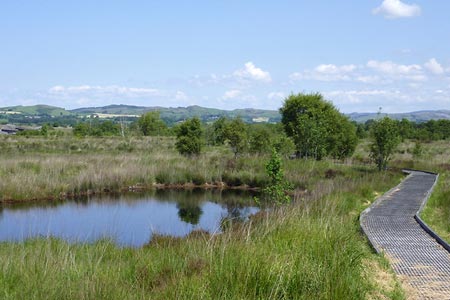
This Cors Caron walk explores the wetlands on the Afon Teifi that lie a few miles north of Tregaron. It is worth noting that the initial boardwalk leads to very boggy ground at the start of the Riverside Walk. The path may flood during wet weather. Red-topped marker posts guide the way over the wetland. Note that for a period during the summer, the Riverside Walk is closed to permit grazing management. It is also closed on several Saturdays during the winter. Signs are erected giving details of these necessary restrictions. More information can be obtained by telephoning the Reserve Manager on 01974 298480 during office hours.
1 - From the Car Park (Grid ref. SN692625), turn left along the old railway, until you reach a set of three sculpted wooden arches on the right. Turn right and pass through these arches on to the boardwalk. Follow the boardwalk until you pass a succession of ponds on your left. Continue along the boardwalk until you arrive at a short flight of steps on your right and a sign giving details of the Riverside Walk (dogs are not permitted beyond this Point).
2 - From this point, visitors who would care to make use of the informative observatory should continue along the boardwalk to a junction on the right, and follow this to the observatory building. Return to the steps to continue the Riverside Walk.
3 - Descend the steps and follow the short section of boardwalk to a gate. Pass through the gate and continue along the boggy path that crosses the wet rushy meadow. As the ground rises slightly, and just before a gate, turn left and follow the red-topped posts that will guide you between the wetland to the left and the farmland to the right.
4 - The grassy and sometimes boggy trail continues through a gate, and follows the farmland edge to a point, marked with a post, where the trail turns sharply to the left to follow a raised bank towards the river. Turn right to cross the small wooden bridge. The trail now continues to the next red-topped post where it adjoins the river bank.
5 - Cross three double planks with handrail, one marked 4, then a stile. Now head deeper into the fen alongside the river on a grassy bank. The river now twists and turns, at one point forming a swan's neck - as always keep an eye out for red-topped guideposts. Eventually cross two more bridges, the second of which crosses a larger side stream from the right. Turn sharp left after this to continue following the riverbank, and two more river meanders later, reach the end of the riverside section. This is indicated by a red-topped post with an arrow directing a turn to the right.
6 - Bear right over a section of boardwalk and a bridge, and then it's an easy boardwalk all the way to the old railway track. Turn right and follow this back to the car.
Maps 

| Ordnance Survey Explorer 187 | Sheet Map | 1:25k | BUY |
| Anquet OS Explorer 187 | Digital Map | 1:25k | BUY |
| Ordnance Survey Explorer 199 | Sheet Map | 1:25k | BUY |
| Anquet OS Explorer 199 | Digital Map | 1:25k | BUY |
| Ordnance Survey Digital Map Subscription | |||
| Latest Ordnance Survey Discounts | |||
Other walks nearby
| Walk 1361 | Tregaron & Twm Town circular | easy | 3.5 miles |
| Walk 1364 | Tregaron & Llandewi Brefi circular | easy/mod | 4.5 miles |
| Walk 1367 | Cwm Berwyn from Tregaron | moderate | 11.0 miles |
| Walk 1363 | The Elephant Walk from Tregaron | easy/mod | 5.5 miles |
| Walk 1365 | Strata Florida to Tregaron | moderate | 9.5 miles |
| Walk 1366 | Pentre Bach circular | easy/mod | 9.5 miles |
| Walk 2736 | Teifi Pools from near Strata Florida | easy/mod | 6.2 miles |
| Walk 3086 | Pen y Garn from near Devil's Bridge | easy/mod | 6.8 miles |
| Walk 3674 | Claerwen Valley & Dam from Dolymynach Reservoir | moderate | 7.4 miles |
| Walk 2498 | Gorllwyn circuit, Elan Valley | easy/mod | 6.8 miles |
Recommended Books & eBooks
The Wales Coast Path
 A single guidebook to walking the whole Wales Coast Path - 1400km (870 miles) the length of Wales from Chester to Chepstow, including Anglesey, described in 57 stages. The route passes through the Snowdonia and Pembrokeshire National Parks and many AONBs and can be linked with the Offa's Dyke Path for a complete circuit of Wales.
More information
