 Walking Britain
The River Arun & South Stoke from Amberley
South Downs Walk
Nat Park - South Downs
County/Area - West Sussex
Author - Lou Johnson
Length - 4.6 miles / 7.5 km Ascent - 250 feet / 76 metres
Time - 2 hours 20 minutes Grade - easy
Walk Route Description
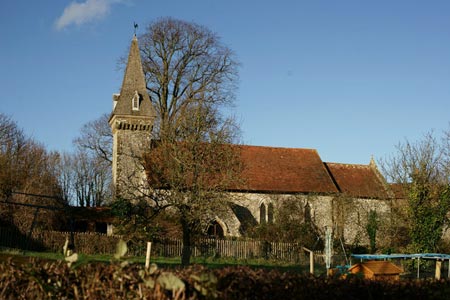
Click image to see photo description.
This short walk explores a section of the River Arun and visits the attractive church at South Stoke.
Exit Amberley station and walk down to the main road. Turn left to Houghton Bridge over the River Arun. Half way across the bridge take the footpath on the left. This leads you alongside the River Arun on the east bank of the river. Reaching a footbridge (grid ref TQ021113) cross the dyke and stile, and turn left away from the river. The path leads to Stoke Road (grid ref. TQ024109). Turn right along the road into the village of North Stoke. Reaching a T-junction turn left to take a path on the right within a few yards.
This path crosses a small suspension bridge continuing to reach the River Arun and a road bridge close to South Stoke (grid ref. TQ026101). Walk up past St Leonard's church to take the bridleway on the right just after South Stoke Farm. This bridleway then follows the west bank of the River all the way back to Houghton. At grid ref. TQ014103 the Monarch's way comes in from the left. Leave the riverside path and climb into Houghton. Reaching the main road through the village turn right and then almost immediately along a lane. Follow this north to reach the South Downs Way which crosses this lane at grid ref. TQ016118. Turn right onto the SDW, cross the footbridge over the River Arun and then follow the north bank back to Amberley station.
Maps 
| Ordnance Survey Explorer OL10 | Sheet Map | 1:25k | BUY |
| Get Ordnance Survey Digital Map Subscription | |||
| Latest Ordnance Survey Discounts | |||
Other walks nearby
| Walk 1917 | Rackham Hill from Amberley | easy/mod | 6.5 miles |
| Walk 1615 | Amberley & East Dean Circular | mod/hard | 21.0 miles |
| Walk 1466 | Amberley and Arundel Circular | moderate | 13.0 miles |
| Walk 1628 | Bignor Hill and The Denture from Amberley | moderate | 8.7 miles |
| Walk 3305 | Amberley Mount & Wepham Down from Burpham | easy/mod | 8.0 miles |
Start Point Details
Ordnance Survey Grid Ref TQ026117
Latitude 50.895677 Longitude -0.54247868
Postcode BN18 9LR
what3words start shell.flickers.result
Walk description may contain detailed information on the start point for this walk.
Further Information
South Downs Walking
The South Downs is Britain's newest National Park and stretches from Winchester to Beachy Head. Steeped in history there are ancient hill-forts, barrows, a Roman road and deserted medieval villages. The area has a rich diversity of natural habitats including flower-studded chalk grassland, ancient woodland, flood meadow, lowland heath and the particularly rare chalk heathland. This varied environment provides an excellent basis for those who enjoy outdoor pursuits, such as walking, cycling and horse riding.
Walking GuideAccommodation
Find Accommodation nearby by using the regional accommodation lists
Go to regional accommodation lists
Self Catering & Cottage Holidays
Properties throughout the UK & Europe
Messaging & Social Media
Message Walking Britain and follow the latest news.


Mountain Weather
Stay safe on the mountains with detailed weather forecasts - for iOS devices.